Library Catalog
Latest Documents and Publications listed. Use search terms in the box below to find what you need
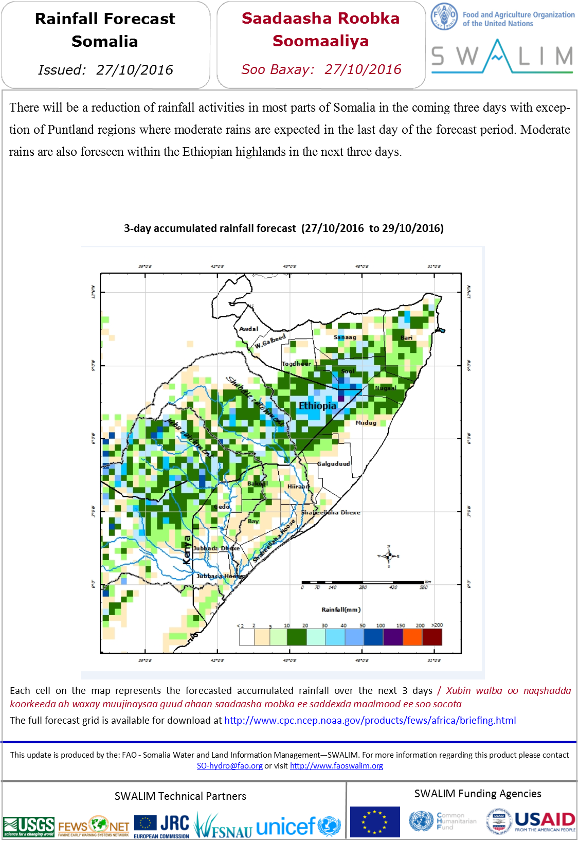
Saadaasha Roob da’a Soomaaliya 27-10-2016
Saddexda maalmood ee soo socota waxaa qaybo badan oo ka tirsan Soomaaliya ka jiri doona arrin roob yaraan marka laga reebo gobollada Puntland halkaas oo laga rajeynaayo roobab dhexdhexaad ah maalmaha dambe ee muddada la saadaaliyey. Waxaa kale oo saddexda maalmood ee soo fool leh laga saadaalinayaa xagga buuraleyda sare ee Itoobiya roobab dhexdhexaad ah.
Publication Type:
Rainfall Forecast
Publication Date:
Author:
Corporate Author:
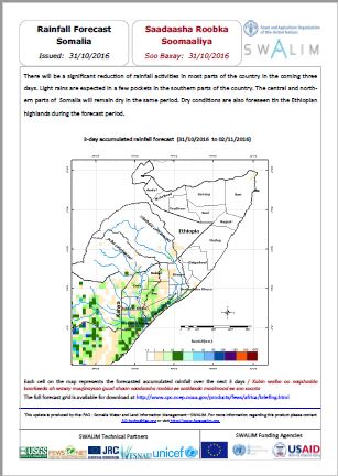
Somalia Rainfall Forecast 31-10-2016
There will be a significant reduction of rainfall activities in most parts of the country in the coming three days.
Light rains are expected in a few pockets in the southern parts of the country. The central and northern parts of Somalia will remain dry in the same period.
Dry conditions are also foreseen tin the Ethiopian
highlands during the forecast period.
Publication Type:
Rainfall Forecast
Publication Date:
Author:
Corporate Author:
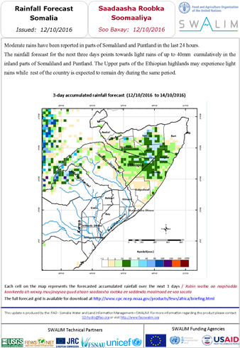
Somalia Rainfall Forecast 12-10-2016
Moderate rains have been reported in parts of Somaliland and Puntland in the last 24 hours.
The rainfall forecast for the next three days points towards light rains of up to 40mm cumulatively in the inland parts of Somaliland and Puntland. The Upper parts of the Ethiopian highlands may experience light rains while rest of the country is expected to remain dry during the same period.
Publication Type:
Rainfall Forecast
Publication Date:
Author:
Corporate Author:
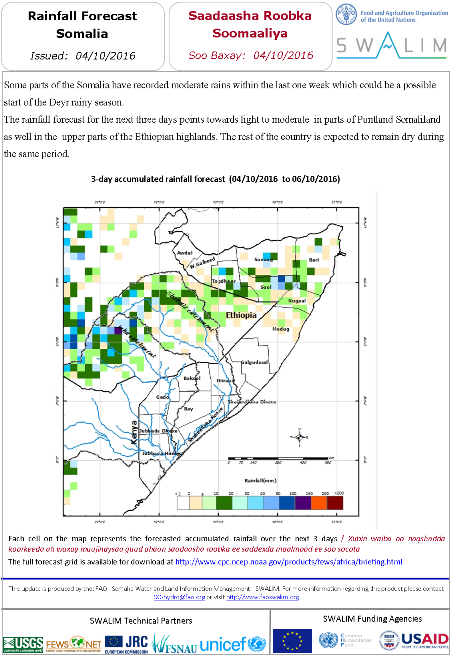
Somalia Rainfall Forecast 04-10-2016
Some parts of the Somalia have recorded moderate rains within the last one week which could be a possible start of the Deyr rainy season.
The rainfall forecast for the next three days points towards light to moderate in parts of Puntland Somaliland as well in the upper parts of the Ethiopian highlands. The rest of the country is expected to remain dry during the same period.
Publication Type:
Rainfall Forecast
Publication Date:
Author:
Corporate Author:
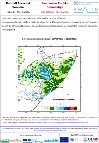
Somalia Rainfall Forecast 19-10-2016
Light to moderate rains have continued to be received in parts of Somalia.
In the coming three days light to moderate rains of up to 40mm are expected in the central parts of the country and the Ethiopian Highlands. The northern and southern regions are expected to remain dry during the forecast period
Publication Type:
Rainfall Forecast
Publication Date:
Author:
Corporate Author:
Saadasha roob da’a Soomaaliya
Qaybo ka mid ah Soomaaliya waxaa la diiwaaniyey roobab dhexdhexaad ah intii lagu jirey halkii toddobaad ee danbe taas oo noqon karta suurogal bilowgii xilliga roobka Deyrta.
Saadaasha roob da’a ku saabsan saddexda maalin ee soo xigta waxay tilmaamayaan khafiif ilaa dhexdhexad gudaha Puntland iyo Somaliland sidoo kale gudaha qaybaha kore ee dhulka-sare ee Itoobiya. Inta soo hartay dalka waxaa la filayaa in ay ahaato engegan inta lagu guda jiro muddada la midka ah.
Publication Type:
Rainfall Forecast
Publication Date:
Author:
Corporate Author:
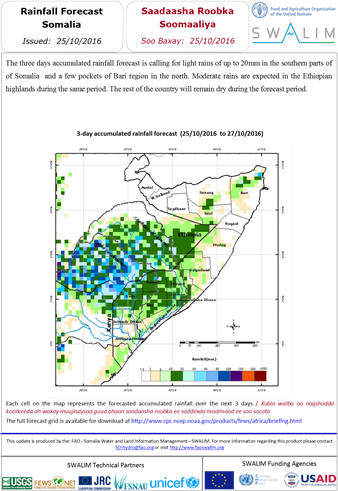
Somalia Rainfall Forecast 25-10-2016
The three days accumulated rainfall forecast is calling for light rains of up to 20mm in the southern parts of of Somalia and a few pockets of Bari region in the north.
Moderate rains are expected in the Ethiopian highlands during the same period. The rest of the country will remain dry during the forecast period.
Publication Type:
Rainfall Forecast
Publication Date:
Author:
Corporate Author:
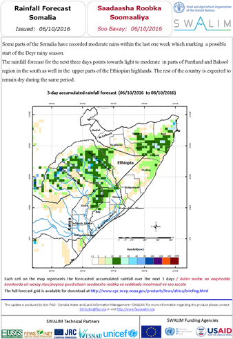
Somalia Rainfall Forecast 06-10-2016
Some parts of the Somalia have recorded moderate rains within the last one week which marking a possible start of the Deyr rainy season.
The rainfall forecast for the next three days points towards light to moderate in parts of Puntland and Bakool region in the south as well in the upper parts of the Ethiopian highlands. The rest of the country is expected to remain dry during the same period.
Publication Type:
Rainfall Forecast
Publication Date:
Author:
Corporate Author:
Saadaasha Roob da’a Soomaaliya 31-10-2016
Waxaa saddexda maalmood ee soo socota gudaha qaybaha dalka inta badan ka jiri doona hoos u dhac xoogan oo ah arrimaha roob da’a. Roobab fudud ayaa laga rajeynayaa gudaha dhowr goobood oo ka tirsan qaybaha koonfureed ee dalka. Qaybaha bartamaha iyo waqooyiga Soomaaliya waxay ahaan doonaa qalayl isla muddada iyada aha. Xaalado qalalan ayaa waxaa sidoo kale laga saadaalinayaa gudaha buuraleyda sare ee Itoobiya inta lagu guda jiro muddada la saadaaliyey.
Publication Type:
Rainfall Forecast
Publication Date:
Author:
Corporate Author:
Somalia Rainfall Forecast 27-10-2016
There will be a reduction of rainfall activities in most parts of Somalia in the coming three days with exception of Puntland regions where moderate rains are expected in the last day of the forecast period. Moderate rains are also foreseen within the Ethiopian highlands in the next three days.
Publication Type:
Rainfall Forecast
Publication Date:
Author:
Corporate Author:
Pages
 RSS feed [compliant with the Agris AP] |
  Agris AP XML