Library Catalog
Latest Documents and Publications listed. Use search terms in the box below to find what you need

Somalia Water Sources Information Management System(SWIMS)
The purpose of the Somalia Water Information Management System (SWIMS) is to provide a mechanism for constructing and maintaining an inventory of Water Sources in Somalia to
Publication Type:
Other
Publication Date:
Author:
John Cody
Corporate Author:
Somalia Water and Land Information Management, Nairobi (Kenya)
Hydrogeological report on 8 borehoes in Central and Southern Somalia
The hydro-geological survey and drilling 8 boreholes aims to improve the availability of water in areas identified as high priority and those having acute shortage of water supply. These include areas of settlement of vulnerable groups such as returnees, IDPs and pastoral population in drought stricken regions of Somalia
Publication Type:
Other
Publication Date:
Author:
Corporate Author:
Awale Drilling Company and Engineering Contractors
Publication Type:
Other
Publication Date:
Author:
Corporate Author:
Geomatec Engineering and Management
Publication Type:
Other
Publication Date:
Author:
Bonnemayer J, Somalia Water and Land Information Management, Nairobi (Kenya)
Corporate Author:
Mapping Global Cities: GIS methods in Urban analysis
Mapping Global Cities: GIS Methods in Urban Analysis shows how the analysis of relevant data with GIS can provide powerful new perspective in addressing urban research and policy questions, and it enhances our understanding and efforts in solving urban planning problems. Author Aye Pamuk draws upon her extensive fieldwork in developing countries, as well as more than ten years of work as a university professor, and extends those in new ways by using the power of spatial analysis with GIS. Part I of the book shows how analysts use GIS to explore global metropolitan regions, and provides an overview of spatial data used in GIS analysis. Part II shows how urban planners and policy makers use GIS, emphasizing the issue of local government and social service delivery. Part III shows how researchers use GIS to analyze spatial patterns in metropolitan areas, including locating immigrant clusters with census data and comparing immigrant clustering patterns across metropolitan areas. The bookandrsquos accompanying CD contains data and printable, step-by-step GIS exercise including a self-directed project, that enable students and users to make maps and explore themes covered in the chapters.
Publication Type:
Other
Publication Date:
Author:
Pamuk A., San Francisco
Corporate Author:
Country environmental profile for Somalia, August 2006
This CEP provides environmental, Social and economic information to the EC Somalia office to Guide the identification of specific recomendations on enviromental objectives and benchmarks for the EC cooperation activities in ita 2008-2013 indicative programed for Somalia
Publication Type:
Other
Publication Date:
Author:
Corporate Author:
The World Conservation Union
FAO SWALIM water sources - ACF survey - Bay
Water sources map for Bay region of Somalia. Map produced using data from ACF survey on Somalia Water sources. To request this map quote the reference: WAT-WATER-17012006-NA3815-A1-001
Publication Type:
Other
Publication Date:
Author:
Corporate Author:
Somalia Water and Land Information Management, Nairobi (Kenya)
Ground water resources investigations
(Extract from summary) This report summarizes the result of the hydrogeological and geophysical studies carried out to assess groundwater potential of the Puntland State of Somali for Mam and Bros drilling company/UNDP project.
Publication Type:
Other
Publication Date:
Author:
Corporate Author:
United Nations Development Program, Mam and Bros drilling Company Ltd, Geolink Associates
Flora of Somalia, Volume 3 with cummulative index to volume 1-4
The aim of the project is to cover all vascular plants known to occur in Somalia, and establish a foundation for all future plant related work in the country. This volume is the last to appaer in a series of four and covers 33 families with a total of more than 1000 species, of which 137 have been described as new within the project. Twenty eight further new species, described in the last few years, which are additional to the previuos published volumes 1, 2 and 4, are included in the appendix, along with a number of species that represent new records for the country. Indexes vernacular and scientific names conclude the volume, and a cummulative index to all four volumes is also provided.
Publication Type:
Other
Publication Date:
Author:
Thulin M. (Editor)
Corporate Author:
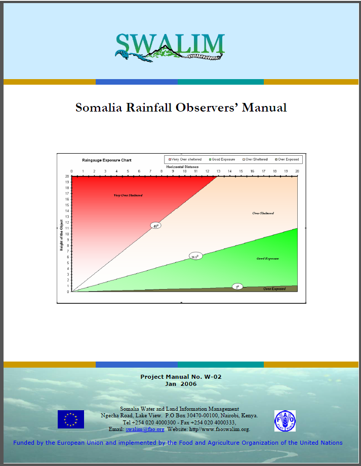
W-02 somalia rainfall observers' manual
SWALIM is re-establishing the national manual rain-gauge network as part of its water and land information systems. The national data set formed will be used to support climate mapping, flood early warning and other hydrological studies. The data set will also be freely accessible to any interested parties. SWALIM will maintain the observations of each station in a dedicated database which will be handed over to an emerging Somali authority at the appropriate time.
Publication Type:
Technical report
Publication Date:
Author:
Muchiri P.W.
Corporate Author:
SWALIM, Somalia Water and Land Information Management, Nairobi (Kenya)
Pages
 RSS feed [compliant with the Agris AP] |
  Agris AP XML