Swalim News and Events
Somalia Ground Water Monitoring Webinar
FAO SWALIM in collaboration with the Federal Government of Somalia’s Ministry of Energy and Water Resources will be hosting a webinar to discuss the ongoing Groundwater monitoring in Somalia. This critical information will be instrumental in planning for the forecast LaNina and related humanitarian interventions.FAO-SWALIM Work in Puntland
Since 2006 Somalia Water and Land Information Management (SWALIM) has been operating in Puntland. Informative data has been collected on land, water and climate. The information is organized in themes: Water resources (Climate, floods, water resources and water reports); Land resources (Land degradation, Land suitability, soils and land reports). This information is generated with the support of a strong Information management, GIS and remote sensing units in collaboration with Puntland government partner institutions. SWALIM information management team has organized the data to facilitate quick retrieval through a variety of online and offline platforms. Download publication (pdf, 3.5 MB)
The Puntland water and land resources – Information Management Center
The Information Management Center (IMC) will be a special agency under the Puntland State of Somalia whose main function shall be to collect, process and analyze water and land resources information in coordination with the relevant government institutions, in support of policy development for sustainable and integrated water and land resources management, and to provide water and land related data and information to the end users. Download pdf(2.5 MB)
Journal Publications
Locally Defined Seasonal Rainfall Characteristics within the Horn of Africa Drylands from Rain Gauge ObservationsIn focus
Intensifying Somalia drought likely to be as severe as previous prolonged dry periods, FAO warns
New data compiled by the Food and Agriculture Organization (FAO) shows that the 2025-26 drought is intensifying rapidly and is likely to be as severe and widespread as previous major droughts of 2022, 2017 and 2011. The analysis is based on data compiled by FAO’s Somali Water and Land Information Management System (SWALIM) system, who have recently updated their Combined Drought Index (CDI).
SWALIM conducted an early warning (diginin) systems training to ministry of Agriculture development in Somaliland
Across climate-vulnerable regions, timely data alone is not enough to prevent crises. The real challenge lies in ensuring that early warning information is clearly understood, trusted, and used to guide decisions. Many professionals receive climate and hazard data but lack the confidence or skills to translate it into action.
From Early Warning to Early Action: Empowering National and State Institutions to Strengthen Flood Resilience in Somalia
Across Somalia, recurrent flooding continues to undermine food security, displace families, and erode development gains, particularly in riverine and low-lying areas. While floods are a recurring hazard, their impacts are increasingly predictable. Building resilience therefore depends not only on forecasting floods, but on strengthening national systems that enable early, anticipatory action to protect lives, livelihoods, and essential services before damage occurs.
SWALIM Issues the Somalia Groundwater Monitoring Bulletin
Groundwater remains Somalia’s most critical and dependable water source, sustaining urban and rural populations, pastoral livelihoods, and productive sectors especially as surface water availability continues to decline during the ongoing drought.SWALIM Publications
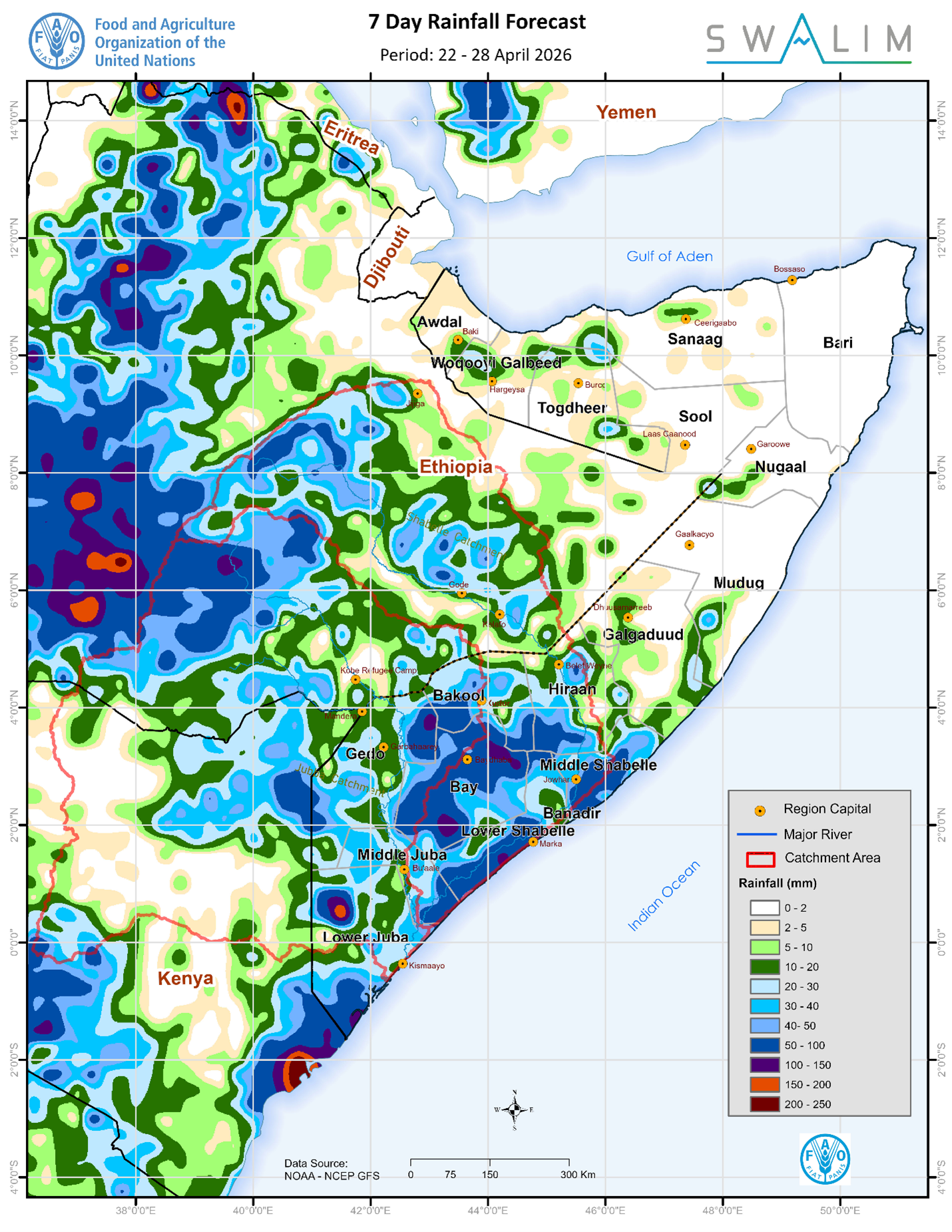
Somalia Rainfall Forecast – Issued 23 April 2026
Rainfall remains uneven, concentrated in southern districts (Lower Juba, Bay, and Gedo regions) and northern regions remain mostly dry during the coming week., very heavy rainfall is highly localized in Lower Juba with flash flooding risk in prone areas, high temperatures persist across central andPublication Download
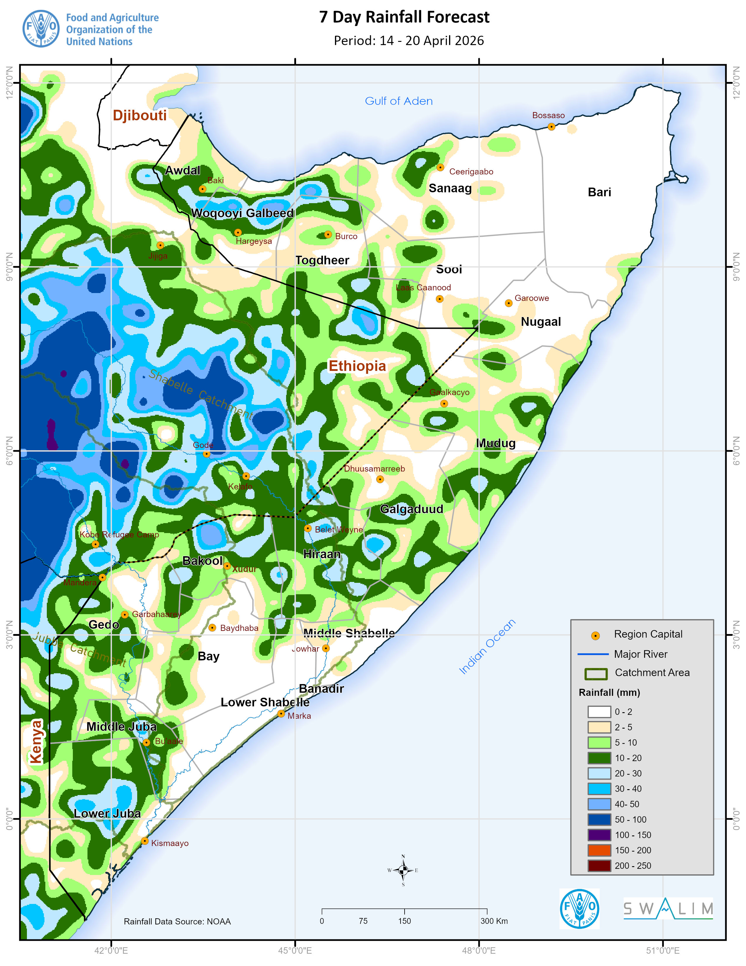
Somalia Rainfall Forecast – Issued 14 April 2026
Light to moderate rain is expected over parts of northern Somalia (Awdal, Woqooyi Galbeed, Sanaag, Togdheer) and localized areas in the south (Gedo, Lower and Middle Juba), while dry conditions dominate central and southern regions High temperatures (35–40°C) will persist across much of central andPublication Download
Somalia Rainfall Forecast – Issued 8 April 2026
According to NOAA-NCEP GFS, light rainfall is expected over most parts of Awdal, Woqooyi Galbeed, Sanaag, Togdheer, Lower Juba, Middle Juba, and Gedo regions.Publication Download
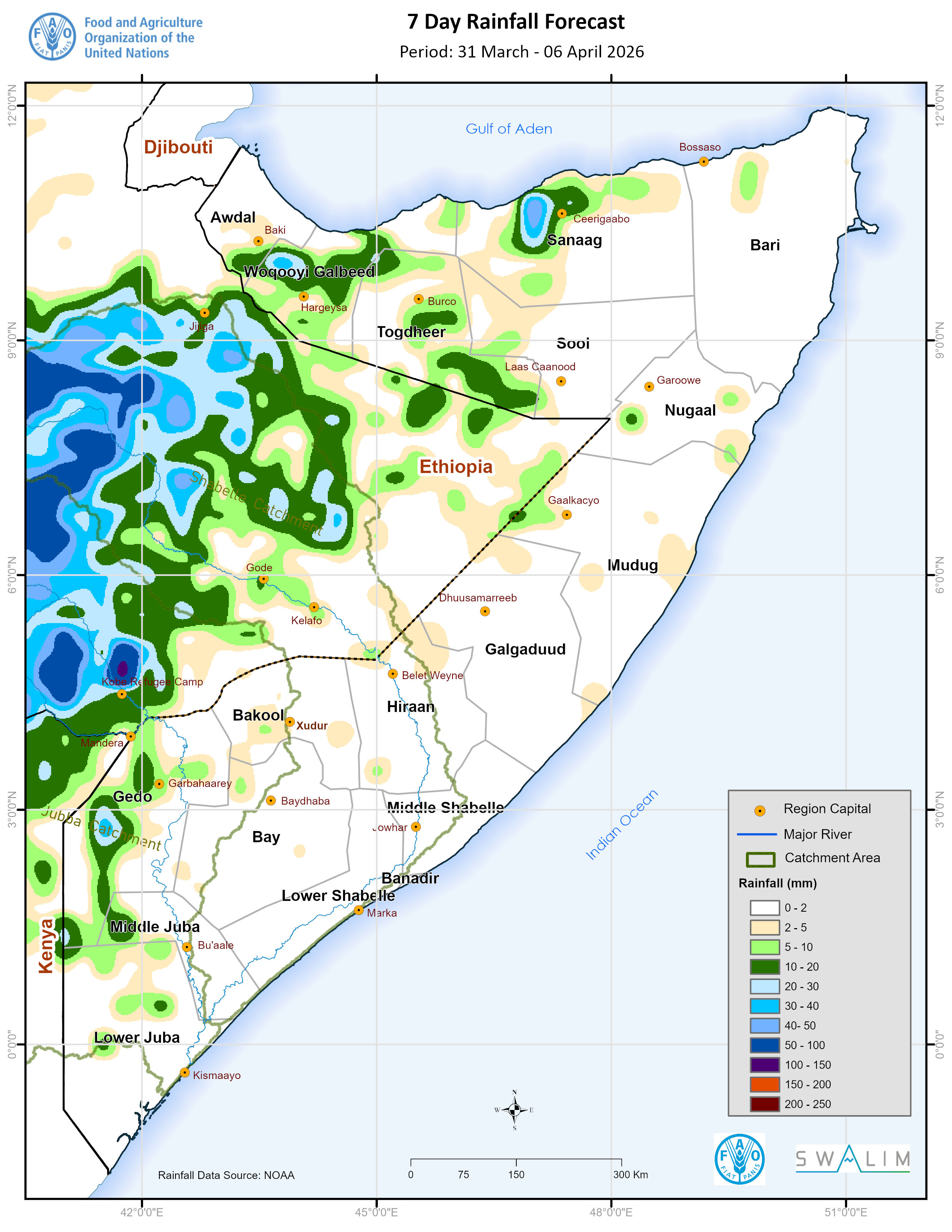
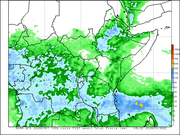
Somalia Rainfall Forecast – Issued 31 March 2026
Light rainfall is expected over parts of Gedo, Awdal, Waqooyi Galbeed, and northern Sanaag. The April outlook favors above-normal rainfall over much of southern and central Somalia. Very high temperatures (35–40°C) are expected across much of central and southern Somalia.Publication Download
Donors
SWALIM is a multi-donor project managed by FAO and currently funded by The European Union, The World Bank, FCDO, AICS, SDC, Canada, Sweden and GCF

![]()

![]()
![]()

![]()
![]() ;
;