Library Catalog
Latest Documents and Publications listed. Use search terms in the box below to find what you need
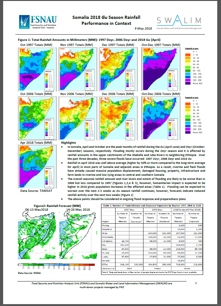
Somalia Gu Rainfall Performance Update May 2018
Rainfall in April 2018 was well above average (higher by 50% or more compared to the long-term average for April) in most parts of Somalia and adjacent areas in Ethiopia. As a result, riverine and flash floods have already caused massive population displacement, damaged housing, property, infrastructure and farm lands in riverine and low-lying areas in central and southern Somalia
The overall seasonal rainfall amount and river levels and extent of flooding are likely to be worse than in 2006 but less compared to 1997; however, humanitarian impact is expected to be higher in 2018 given population increases in the affected areas. Flooding can be expected to worsen over the next 2-3 weeks as Gu season rainfall continues; however, forecasts indicate reduced rainfall activity over the next two weeks.
Publication Type:
Rainfall Performance
Publication Date:
Author:
Corporate Author:

Validation of the CHIRPS satellite rainfall estimates over eastern Africa
Long and temporally consistent rainfall time series are essential in climate analyses and applications. Rainfall data from station observations are inadequate over many parts of the world due to sparse or non‐existent observation networks, or limited reporting of gauge observations. As a result, satellite rainfall estimates have been used as an alternative or as a supplement to station observations. However, many satellite‐based rainfall products with long time series suffer from coarse spatial and temporal resolutions and inhomogeneities caused by variations in satellite inputs. There are some satellite rainfall products with reasonably consistent time series, but they are often limited to specific geographic areas. The Climate Hazards Group Infrared Precipitation (CHIRP) and CHIRP combined with station observations (CHIRPS) are recently produced satellite‐based rainfall products with relatively high spatial and temporal resolutions and quasi‐global coverage. In this study, CHIRP and CHIRPS were evaluated over East Africa at daily, dekadal (10‐day) and monthly time‐scales. The evaluation was done by comparing the satellite products with rain‐gauge data from about 1,200 stations. The CHIRP and CHIRPS products were also compared with two similar operational satellite rainfall products: the African Rainfall Climatology version 2 (ARC2) and the Tropical Applications of Meteorology using Satellite data (TAMSAT). The results show that both CHIRP and CHIRPS products are significantly better than ARC2 with higher skill and low or no bias. These products were also found to be slightly better than the latest version of the TAMSAT product at dekadal and monthly time‐scales, while TAMSAT performed better at the daily time‐scale. The performance of the different satellite products exhibits high spatial variability with weak performances over coastal and mountainous regions.
Publication Type:
Journal Article
Publication Date:
Author:
Chris Funk, Tufa Dinku, Gadain H.M.
Corporate Author:
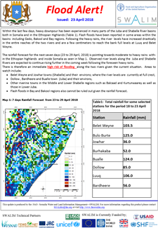
Somalia Flood Alert! - Issued: 23 April 2018
Within the last few days, heavy downpour has been experienced in many parts of the Juba and Shabelle River basins both in Somalia and in the Ethiopian Highlands. Flash floods have been reported in some areas within the basins including Gedo, Bakool and Bay regions. Following the heavy rains, the river levels have increased drastically in the entire reaches of the two rivers and are a few centimeters to reach the bank full levels at Luuq and Belet Weyne.
The rainfall forecast for the next seven days (23 to 29 April, 2018) is pointing towards moderate to heavy rains within the Ethiopian highlands and inside Somalia. Observed river levels along the Juba and Shabelle Rivers are expected to continue rising further in the coming week following the foreseen heavy rains.
There is therefore an immediate high risk of flooding along the two rivers given the current situation. Areas to watch include;
Belet Weyne and Jowhar towns (Shabelle) and their environs; where the river levels are currently at full crest,
Dollow , Bardheere and Bualle town (Juba) and their environs,
Other riverine towns in the Middle and Lower Shabelle regions such as Balcaad and Kurtunwaarey as well as those in Lower Juba.
Flash floods in Bay and Bakool regions also cannot be ruled out given the rainfall forecast.
Publication Type:
Flood Alert
Publication Date:
Author:
Corporate Author:
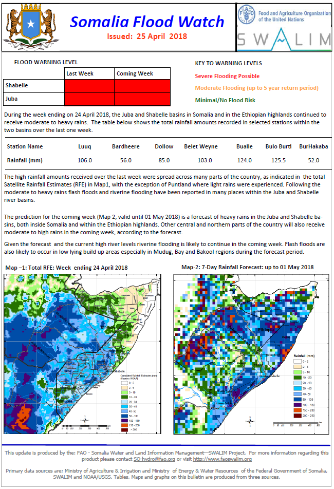
Somalia Flood Watch Bulletin - Issued 25 April 2018
During the week ending on 24 April 2018, the Juba and Shabelle basins in Somalia and in the Ethiopian highlands continued to receive moderate to heavy rains.
The high rainfall amounts received over the last week were spread across many parts of the country, as indicated in the total Satellite Rainfall Estimates (RFE) in Map1, with the exception of Puntland where light rains were experienced. Following the moderate to heavy rains flash floods and riverine flooding have been reported in many places within the Juba and Shabelle river basins.
The prediction for the coming week (Map 2, valid until 01 May 2018) is a forecast of heavy rains in the Juba and Shabelle basins, both inside Somalia and within the Ethiopian highlands. Other central and northern parts of the country will also receive moderate to high rains in the coming week, according to the forecast.
Given the forecast and the current high river levels riverine flooding is likely to continue in the coming week. Flash floods are also likely to occur in low lying build up areas especially in Mudug, Bay and Bakool regions during the forecast period.
Publication Type:
Flood watch bulletin
Publication Date:
Author:
Corporate Author:

Somalia Rainfall Forecast - Issued 04 may 2018
Enhanced rains are foreseen in the coming week in many parts of the country with Bay and Bakool regions in the south expected to record the highest amounts of rainfall. The Ethiopian highlands will also continue to receive good rains during the period in forecast.
The foreseen moderate to heavy rains are likely to exacerbate ground conditions, and trigger additional floods. Built up and low Lying areas of Bay and Bakool will experience flash floods while river flooding along the Juba and Shabelle Rivers will continue.
Publication Type:
Rainfall Forecast
Publication Date:
Author:
Corporate Author:

Somalia Rainfall Forecast 16-04-2018
Moderate to heavy rains have been received in many parts of the country over the last two days. Flash floods have been reported in many places including Bakool, Hiraan and Middle Shabelle regions.
The rainfall forecast for the coming week is pointing towards moderate to heavy rains. Low lying areas and built up areas may experience flash floods during the week.
River levels along the Juba and Shabelle are expected to continue rising. There is a high risk of flooding in Middle and Lower Shabelle regions following the dramatic river level increase in he last 48 hours. No flooding risk is foreseen along the Juba River during the period under review.
Publication Type:
Rainfall Forecast
Publication Date:
Author:
Corporate Author:

Somalia Flood Watch Bulletin - Issued: 18 April 2018
During the week ending on 17 April 2018, the Juba and Shabelle basins in Somalia and in the Ethiopian highlands continued to receive moderate to heavy rains. Following the heavy rains, flash floods were reported in many places within the two basins leading to displacements, inundation of croplands and destruction of property. The table below shows the total rainfall amounts recorded in selected stations within the two basins over the last one week.
Map 1 shows the total Satellite Rainfall Estimates (RFE) of last week which shows moderate to heavy rains within the basins. Middle and Lower Juba regions received the highest amounts of rainfall of more than 100mm in total over the week. Map 2 shows the rainfall forecast for coming week valid until 24 April 2018 and is calling for more rains in the basins.
Following the good rains river levels along the Juba and Shabelle rivers continued to rise reaching the high flood risk levels in the upper and mid sections of the two rivers.
Given the rainfall forecast and the high river levels, there is a high risk of flooding in the middle and lower reaches of the Juba and Shabelle rivers with some sections having experienced overbank river flow due to weak river embankments and open river breakages.
Flash floods in built up and low lying areas within the basins cannot be ruled out during the period under review
Publication Type:
Flood watch bulletin
Publication Date:
Author:
Corporate Author:
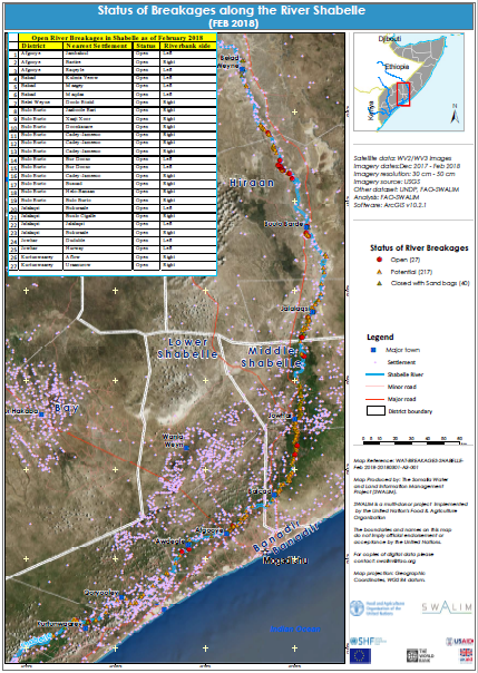
Status of River Breakages Along Shabelle Rivers as at Feb 2018
The Gu 2018 (April to June) rainfall forecast points towards near-normal to below-normal rains within the Juba and Shabelle River basin. However, flooding along the two rivers is likely to occur, especially in areas with open river banks/weak river embankments.
FAO SWALIM (Somalia Water and Land Information Management) has updated the status of the river breakages along the Shabelle River and is in the process of updating the Juba by mapping them using available Very High Resolution (VHR) satellite imagery and a Digital Elevation Model (DEM); supported by “ground truthing” field observations where feasible. All the observations reported refers to the latest suitable VHR satellite image available, which is indicated in the online database.
Four types of breakages have been identified, namely; open, potential, closed with sandbags and closed. The open breakages are those that are still open as observed on the latest VHR image available, therefore field verification is needed before planning any repair. The potential breakages represent points that have weak river embankments. The closed with sandbags points are defined here as those that been temporarily closed with sandbags making them still vulnerable for further breakages. The closed points are those that were previously open but have since been closed using heavy machinery or other methods, which prevents further flooding in the short term.
The attached map show the open, potential and closed with sandbags points along the Shabelle River. In summary, 27 open points were identified long the river. Several other points, which are either potential or temporarily closed with sandbags, have been identified.
The methodology is biased towards Remote Sensing (RS) interpretation with only limited “ground truthing” due to access constraints. Open breakages might have been omitted in some cases where satellite images may not have been very clear (e.g. heavy cloud cover) or were not available.
Maps of the status of river breakages, with detailed information, have been produced at large scale and can be obtained from SWALIM offices. This information is also available on the SWALIM Flood Risk and Response Management Information System portal.
Publication Type:
Technical report
Publication Date:
Author:
Corporate Author:
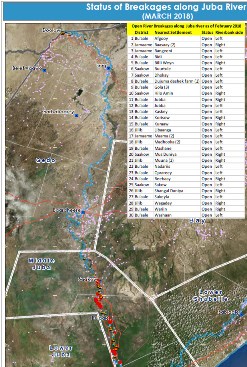
Status of River Breakages Along Juba River as at March 2018
As part of flood preparedness and contingency planning, the FAO Somalia Water and Land Information Management project (SWALIM) has finalized mapping of river breakages along the Juba River using Very High Resolution (VHR) satellite images. The middle and lower parts of the river are most vulnerable to flooding. Three types of breakages have been identified namely; open (37), potential (191) and closed with sand bags (21).
The open breakages are those that were still open during the period of investigation. The potential breakages represent points that have very weak river embankment or have experienced several breakages in the recent past. The closed with sand bags breakages are those that were previously open but efforts have been made to close them although they are still at risk. The open river breakages pose an immediate danger and high risk of flooding.
Publication Type:
Map
Publication Date:
Author:
Corporate Author:

Somalia Rainfall Forecast 13-03-2018
While the Gu season is yet to start in Somalia, light to moderate rains were reported in parts of Somaliland since the last week of February and first week of March. The upper parts of the Ethiopian highlands also recorded moderate rains during the last two weeks which led to slight increase of river levels along the Juba and Shabelle Rivers inside Somalia.
Light rains are foreseen in a few pockets of Bay and Bakool regions as well as western parts of Somaliland and the Ethiopian highlands in the coming three days (Map 1). The rains are then expected to intensify in space and quantity towards the end of the week (Map 2). Given the rainfall forecast, the river levels are expected to rise with no risk of flooding.
Users are advised that this is a forecast and at times there may be discrepancies between forecast and actual amounts of rainfall received.
Publication Type:
Rainfall Forecast
Publication Date:
Author:
Corporate Author:
Pages
 RSS feed [compliant with the Agris AP] |
  Agris AP XML