Library Catalog
Latest Documents and Publications listed. Use search terms in the box below to find what you need
Somalia Flood Update - Issued 22 October 2019
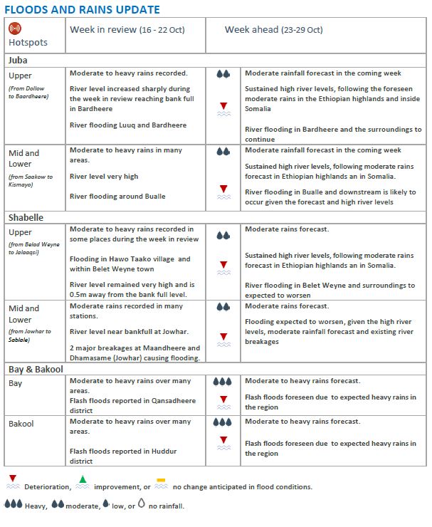
Rainfall activities persisted in the second and third weeks of October inside Somalia and within the eastern Ethiopian highlands. The rains have replenished water sources leading to a reduction of water stress and boosted both pasture growth and crop cultivation. There has been an improvement in livestock body conditions and milk production as well. On the downside, the heavy rains have led to increased river levels along the Juba and Shabelle rivers inside Somalia surpassing the high-risk thresholds for flooding in areas of Belet Weyne and Jowhar along the Shabelle and Bardheere along the Juba. The high river levels have consequently led to overflows, causing floods in low-lying areas along the two rivers.
The worst affected areas along the Shabelle River include Belet Weyne in Hiraan and parts of Middle Shabelle where there has been destruction of property and inundation of farmlands. As of 22 October, the river level at Belet Weyne is at 7.8m which is about half a meter short of the full bank level. Over bank spillages from minor tributaries passing through Belet Weyne town have caused flooding leading to displacements of a significant number of households. The local authority and partners have started to evacuate vulnerable communities to higher grounds within Belet Weyne.
There has also been river flooding in the Ethiopian highlands about 20 Km north of Belet Weyne, and this flood wave is expected to reach Somalia over the next one to two days if rainfall continues, further exacerbating the flood risk inside Somalia. Observed river levels have remained high at Jowhar and Mahadey Weyne districts where large swathes of croplands have been damaged by floods. Existing river breakages (39 points identified and reported by SWALIM in September 2019) could lead to increased flooding if not urgently mitigated.
Dollow, Luuq, Bardheere and Buale districts in Gedo and Middle Juba Regions were also affected by river flooding along the Juba. Field reports indicate that four people lost their lives in Bardheere, and the floods have displaced an estimated 750 households; further, 250 livestock drowned, and the waters damaged about 1,200 farms.
In Bay and Bakool regions, flash floods destroyed cropland (sorghum, maize and cowpeas) that were at the seedling stage. Low lying areas of Gedo were also affected by flash floods over the last one week.
The rainfall forecast for the coming week shows a reduction of rainfall activities especially within the Ethiopian highlands. However, heavy rains are expected in Gedo, Bay and Bakool regions which may lead to flash floods in low-lying areas in these regions. The increasing trend of river levels is expected to continue in the coming week with flooding expected along the Shabelle and Juba rivers.
Publication Type:
Flood Alert
Publication Date:
Author:
Corporate Author:
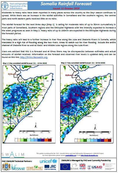
Somalia Rainfall Forecast: Issued 11-10-2019
Moderate to heavy rains have been reported in many places across the country as the Deyr season continues to spread. While there was an increase in the rainfall activities in Somaliland and the southern regions, the central parts and north eastern parts received little on no rains.
The rainfall forecast for the next three days is calling for moderate rains of up to 50mm cumulatively in most parts of Somaliland, Southern regions and the Ethiopian highlands with the intensity expected to increase as the week progresses. Heavy rains of up to 200mm are expected in the Ethiopian highlands during the forecast period.
The heavy rains will lead to a further increase in river flow along the Juba and Shabelle Rivers in Somalia, which translates in a high risk of flooding along the two rivers. Areas to watch out for river flooding include the entire channel of Shabelle River as well as Gedo and Middle Juba regions along the Juba River.
Publication Type:
Rainfall Forecast
Publication Date:
Author:
Corporate Author:
Somalia Flood Update - Issued 25 October 2019
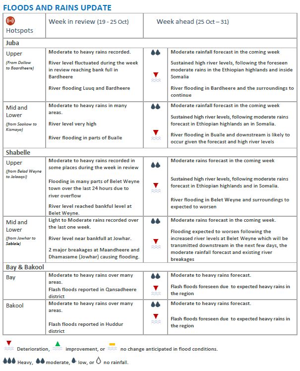
The Deyr (October-December) rains, which started early in many parts of Somalia, continued in the fourth week of October. Moderate to heavy rains were recorded across the country, apart from parts of Bari and Nugal Regions where the rains were light and in some areas no rains at all. The Ethiopian highlands, where the Juba and Shabelle Rivers originate, equally received moderate to heavy rains over the last couple of weeks. River levels along the entire reaches of Juba and Shabelle have been high over the last few weeks, owing to the heavy rainfall both in Ethiopia and Somalia.
Shabelle River: The river level at Belet Weyne reached bankfull level (8.3m) over the last 24 hours. This has led to overbank spillage into Belet Weyne town, and consequently inundating many settlements. The overbank flow is continuing with flood waters expanding fast across the town. Currently the worst affected sections of Belet Weyne town are Kooshin and Xaawo Taako. Destruction of property by floods has also been reported in other parts of Hiraan Region. The local authority and partners have started to evacuate vulnerable communities to higher grounds in the most affected areas.
In Middle Shabelle, floods damaging large areas under cropland have been reported in Jowhar and Mahaday Weyne following high river levels and open river breakages. In Jowhar, the river level reached the threshold for high flood risk since late August, and has since been fluctuating within this level to date. Today’s river level a Jowhar is 5.30m, and the level is expected to rise in the coming few days when the current flood wave in Belet Weyne is transmitted downstream. Existence of river breakages (39 points identified and reported by SWALIM in September 2019) is likely to escalate the flooding situation unless urgent mitigation measures are taken.
Juba River: Along Juba River the levels drastically increased over the last two weeks, surpassing the threshold for moderate flood risk at the upper reaches of the river. Bardheere town is worst affected, with parts of the town inundated. Flooding was also reported in Dollow, Luuq and Buale districts in Gedo and Middle Juba Regions. Currently the levels are high along the entire reach, and any slight increase is likely to cause further flooding.
In Bay and Bakool regions: Heavy rains resulted in flash floods destroying cropland (sorghum, maize and cowpeas). Huddur and Qansadheere districts were the most affected. Low lying areas of Gedo experienced flash floods as well over the last one week.
The rainfall forecast for the coming week (October 25-31, Map 2) shows a reduction of rainfall activities in Somalia, especially in the northern parts of the country where light or no rains are expected. In the central and southern parts of the country as well as the eastern Ethiopian highlands moderate rains are expected within the same period. As a result, the current high river levels, and ongoing riverine flooding, along the Juba and Shabelle rivers are expected to continue in the coming week. Flash floods may also be experienced in low-lying areas where moderate rains are expected.
Publication Type:
Flood Alert
Publication Date:
Author:
Corporate Author:
Somalia Rainfall Forecast: Issued 14-10-2019
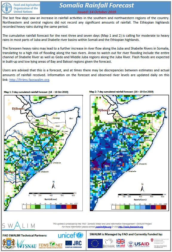
The last few days saw an increase in rainfall activities in the southern and northwestern regions of the country. Northeastern and central regions did not record any significant amounts of rainfall. The Ethiopian highlands recorded heavy rains during the same period.
The cumulative rainfall forecast for the next three and seven days is calling for moderate to heavy rains in most parts of Juba and Shabelle river basins within Somali and the Ethiopian highlands.
The foreseen heavy rains may lead to a further increase in river flow along the Juba and Shabelle Rivers in Somalia, translating to a high risk of flooding along the two rivers. Areas to watch out for river flooding include the entire channel of Shabelle River as well as Gedo and Middle Juba regions along the Juba River. Flash floods are expected in built-up and low lying areas of Bay and Bakool regions given the forecast.
Users are advised that this is a forecast, and at times there may be discrepancies between estimates and actual amounts of rainfall received. Information on the forecast and observed river levels are updated daily on this link: http://frrims.faoswalim.org.
Publication Type:
Rainfall Forecast
Publication Date:
Author:
Corporate Author:
Tropical Storm Alert - Issued 29 October 2019
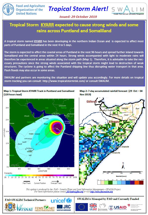
Tropical Storm KYARR expected to cause strong winds and some rains across Puntland and Somaliland
A tropical storm named KYARR has been developing in the northern Indian Ocean and is expected to affect most parts of Puntland and Somaliland in the next 4 to 5 days.
The storm is expected to affect the coastal areas of Puntland in the next 96 hours and spread further inland towards Somaliland and the central areas within 24 hours. Strong winds accompanied with light to moderate rains will therefore be experienced in areas situated along the storm path. Therefore, it is advisable to take the necessary precautions since the strong winds associated with the tropical storm might lead to destruction of weak structures. The cyclone is going to affect the Puntland shipping line thus disrupting water transport in that area. Flash floods may also occur in some areas.
Publication Type:
Flood Alert
Publication Date:
Author:
Corporate Author:
Somalia Rainfall Forecast: Issued 16-10-2019
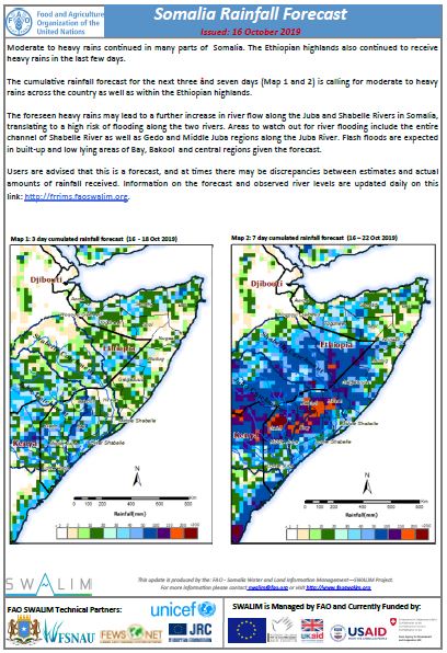
Moderate to heavy rains continued in many parts of Somalia. The Ethiopian highlands also continued to receive heavy rains in the last few days.
The cumulative rainfall forecast for the next three and seven days is calling for moderate to heavy rains across the country as well as within the Ethiopian highlands.
The foreseen heavy rains may lead to a further increase in river flow along the Juba and Shabelle Rivers in Somalia, translating to a high risk of flooding along the two rivers. Areas to watch out for river flooding include the entire channel of Shabelle River as well as Gedo and Middle Juba regions along the Juba River. Flash floods are expected in built-up and low lying areas of Bay, Bakool and central regions given the forecast.
Publication Type:
Publication Date:
Author:
Corporate Author:
Flood Update for Middle and Lower Shabelle - Issued 05-09-2019
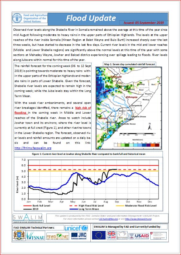
Observed river levels along the Shabelle River in Somalia remained above the average at this time of the year since mid August following moderate to heavy rains in the upper parts of Ethiopian Highlands. The levels at the upper reaches of the river inside Somalia (Hiraan Region at Belet Weyne and Bulo Burti) increased sharply over the last three weeks, but have started to decrease in the last few days. Current river levels in the mid and lower reaches (Middle and Lower Shabelle regions) are significantly above the normal levels at this time of the year with some sections at Mahadey Weyne, Jowhar and Balcad districs experiencing over spillage leading to floods. River levels along Juba are within normal for this time of the year.
Publication Type:
Flood Alert
Publication Date:
Author:
Corporate Author:

Somalia Rainfall Forecast: Issued 27-09-2019
The Deyr 2019 rainy season (September-December) has kicked off in some parts of the country. Parts of the north eastern regions started to receive rains in mid-September. The last 24 hours also saw moderate rains in parts of the Gedo region in the south. The rains are expected to continue spreading in time and space during the coming weeks with the season scheduled to end in November and early December.
The cumulative rainfall forecast for the next three days indicates light to moderate rains in scattered areas of the country, especially within Sool and Sanaag regions. The rains will then spread further as the week progresses with more intensity in the northern areas. The upper parts of the Ethiopian highlands will also receive good rains towards the end of the week. Most parts of the south and central areas will remain dry in the coming week.
Given the rainfall forecast and the existing high river levels along the Shabelle, there is a moderate risk of flooding in the middle reaches of the river. Areas to watch out for floods include Mahadey Weyne, Jowhar, and Balcad districts riverine areas where there exist several open river banks and weak river embankments.
Publication Type:
Rainfall Forecast
Publication Date:
Author:
Corporate Author:

Somalia Rainfall Forecast: Issued 30-09-2019
The cumulative rainfall forecast for the coming week indicates moderate rains in the northern areas and parts of South and central regions bordering Ethiopia. The upper parts of the Ethiopian highlands will also receive good rains during the week.
Given the rainfall forecast and the existing high river levels along the Shabelle, there remains a moderate risk of flooding in the middle reaches of the river. Areas to watch out for floods include Mahadey Weyne, Jowhar, and Balcad districts riverine areas where there exist several open river banks and weak river embankments.
River levels along the Juba are expected to rise at the week with no risk of flooding.
Publication Type:
Rainfall Forecast
Publication Date:
Author:
Corporate Author:

Somalia Rainfall Outlook for Deyr 2019
The Deyr rains are usually shorter and less in quantity than the Gu rains. However, they are beneficial in supporting agricultural activities and boosting water availability for different uses. Generally the season starts in late September and ends in November/December. Nevertheless, this varies from place to place across the country with the northern parts usually receiving the rains much earlier than the southern parts.
According to the recently issued consensus climate outlook for the Greater Horn of Africa (GHACOF53), the 2019 Deyr rainy season in Somalia is expected to be wetter than normal in most areas with warmer than usual temperatures across the whole country. The rainfall forecast indicates 45% to 55% probability of above average rains in the south, central and most parts of the northern regions. This also includes the Ethiopian highlands which contribute significantly to both Juba and Shabelle river flow inside Somalia. Some areas in the north western parts including Awdal, Woqooyi Galbeed and parts of Togdheer regions are expected to have normal to below normal rains as seen in Map 1. The regional forecast further indicates a possibility of a drier than normal month of September and a delayed start of the season in Somalia with dry spells of more than 10 days after the start of the season.
The expected good rains will boost crop production and replenish pasture and water sources in most parts of the country thus reducing water stress significantly. This will bring relief to many parts of the country that had recorded below average rains during the 2019 Gu (April—June) and 2018 Deyr (October-December) rain seasons. Communities, government and intervening agencies are advised to take advantage of the expected good rains to harvest rain-water for the future using simple technologies. On the downside, riverine flooding along the Juba and Shabelle rivers is likely to occur especially in the middle and lower reaches of the two rivers. Existing open river banks and weak embankments can worsen the situation. Flash floods are likely to occur in low lying and built up areas.
The expected below normal rains in the north western regions will lead to further depletion of pasture and water resources with high likelihood of mild to moderate drought conditions. Replenishing of the surface water points may be minimal and therefore communities should use the available resources sparingly. These areas are currently experiencing abnormally dry conditions following the poor performance of the last two rainy seasons. Conflict over the scarce resources cannot be ruled out.
This is a consensus forecast designed for a regional audience that addresses the rainfall totals summed over the three‐month period from October to December 2019. Local and month-to-month variations might occur as the season progresses. Sporadic rainfall events leading to flash floods are likely to occur even in areas with increased likelihood of near to below normal rainfall. Also, dry spells might occur in areas where enhanced rainfall is foreseen.
FAO, through SWALIM and its technical partners, will keep updating this forecast for shorter lead time periods and share updating information throughout the rainfall season.
Publication Type:
Rainfall Outlook
Publication Date:
Author:
Corporate Author:
Pages
 RSS feed [compliant with the Agris AP] |
  Agris AP XML