Library Catalog
Latest Documents and Publications listed. Use search terms in the box below to find what you need
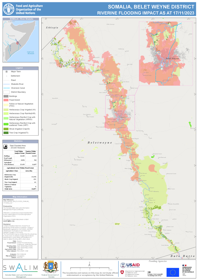
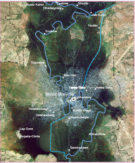
Beletweyne Riverine Flood Impact Map - Issued 17 November 2023
Between the 12th and 15th of November 2023, approximately 24,318 buildings, 562 km of roads and 14,697 Hectares of farms in Belet Weyne were flooded, as depicted on the map. The flood extents were identified through a comprehensive analysis, incorporating data from a modified Global Flood Model (GFM) based on Sentinel-1 image of November 14, 2023, visual interpretation of UNOSAT Beletweyne city extent data of November 12, 2023, and Sentinel-2 image of November 15, 2023.
This inundation had a notable impact on the region, affecting 54% of buildings, 6% of the main road distance, and 41% of agricultural cropland. The data derived from this analysis offers a detailed overview of the extent and consequences of the flooding, facilitating a more informed understanding of the situation for effective response and mitigation efforts.
Publication Type:
Map
Publication Date:
Author:
Corporate Author:
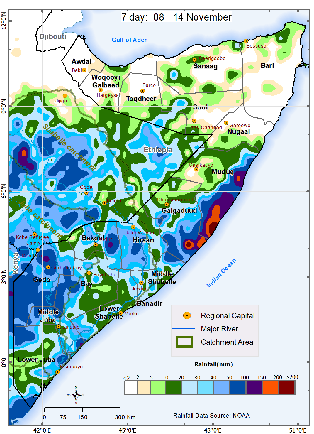
Somalia Rainfall Forecast – Issued 08 November 2023
In the next one-week, heavy rainfall is expected over the coastal parts of Galmudug; moderate to heavy rainfall is likely over Gedo, parts of Bakool, Hiran, Lower Juba, and Middle Juba regions, and dry conditions with chances of isolated light rainfall in anticipated over Somaliland and Puntland (Map 1). The three -days forecast (Map 1) shows that much of the forecast rains over Mudug region are likely to be received between 8th and 10th November 2023. The spatio-temperal variation of the forecast rainfall (Map 1) is described below:
• Heavy rainfall of between 100 mm and 150 mm is expected over several areas in the coastal parts of Galmudug state and in isolated areas in Jilib district in Middle Juba region, Garbaharey and Belet Xaawo districts in Gedo region, and Hudur and Tayeeglow districts in Bakool. The rains over the coastal parts of Galmudug are likely to be intense (more than 150 mm) with the localized storms over Ceel Dheer and Xarardheere districts cumulating to over 200 mm.
• Moderate rainfall of between 50 mm and 100 mm is forecast over several areas in Gedo region, Ceel Dheer and Ceel Buur districts in Galgadudd region, Xarardheere, Hobyo and Jaribaan districts in Mudug region, Bulo Burte district in Hiraan region, and Hudur and Tayeeglow districts in Bakool region. Towards the south, rainfall of similar amount is expected over several areas in Qansax Dheere and Dinsoor districts in Bay region, Jilib and Saakow districts in Middle Juba region, Jamaame district, southern parts of Badhaadhe district, western parts of Afmadow district in Lower Juba region.
• Light to rainfall of below 50 mm is expected over several areas in Lower Shabelle and Middle Shabelle regions, Kismaayo district and central and eastern parts of Afmadow districts in Lower Juba region, central parts of Middle Juba region including Bualle district. Similar rains are also likely over Bur Hakaba abd Baydhaba districts in Bay region, Rab Dhuure, Waajid and Ceel Barde districts in Bakool region, BeletWeyne and Jalalaqsi districts in Hiraan region. In the central parts of country, the areas that are expected to receive rains if similar intensities include: Cabudwaaq, Dhuusamareeb and Cadaado districts in Galgaduud region and Galdogob district in Mudug region.
• Dry conditions are expected over expansive areas in Somaliland and Puntland, except Gaalkacyo district in Mudug region where isolated light rainfall is expected.
Publication Type:
Rainfall Forecast
Publication Date:
Author:
Corporate Author:
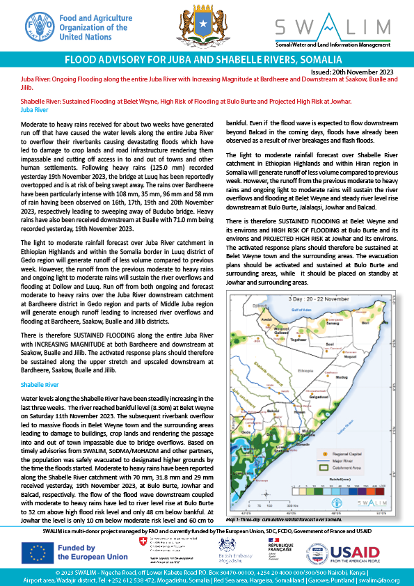
Somalia Flood Advisory for Juba and Shabelle Rivers - Issued 20 November 2023
Juba River
Moderate to heavy rains received for about two weeks have generated run off that have caused the water levels along the entire Juba River to overflow their riverbanks causing devastating floods which have led to damage to crop lands and road infrastructure rendering them impassable and cutting off access in to and out of towns and other human settlements. Following heavy rains (125.0 mm) recorded yesterday 19th November 2023, the bridge at Luuq has been reportedly overtopped and is at risk of being swept away. The rains over Bardheere have been particularly intense with 108 mm, 35 mm, 96 mm and 58 mm of rain having been observed on 16th, 17th, 19th and 20th November 2023, respectively leading to sweeping away of Budubo bridge. Heavy rains have also been received downstream at Bualle with 71.0 mm being recorded yesterday, 19th November 2023.
The light to moderate rainfall forecast over Juba River catchment in Ethiopian Highlands and within the Somalia border in Luuq district of Gedo region will generate runoff of less volume compared to previous week. However, the runoff from the previous moderate to heavy rains and ongoing light to moderate rains will sustain the river overflows and flooding at Dollow and Luuq. Run off from both ongoing and forecast moderate to heavy rains over the Juba River downstream catchment at Bardheere district in Gedo region and parts of Middle Juba region will generate enough runoff leading to increased river overflows and flooding at Bardheere, Saakow, Bualle and Jilib districts.
There is therefore SUSTAINED FLOODING along the entire Juba River with INCREASING MAGNITUDE at both Bardheere and downstream at Saakow, Bualle and Jilib. The activated response plans should therefore be sustained along the upper stretch and upscaled downstream at Bardheere, Saakow, Bualle and Jilib.
Shabelle River
Water levels along the Shabelle River have been steadily increasing in the last three weeks. The river reached bankful level (8.30m) at Belet Weyne on Saturday 11th November 2023. The subsequent riverbank overflow led to massive floods in Belet Weyne town and the surrounding areas leading to damage to buildings, crop lands and rendering the passage into and out of town impassable due to bridge overflows. Based on timely advisories from SWALIM, SoDMA/MoHADM and other partners, the population was safely evacuated to designated higher grounds by the time the floods started. Moderate to heavy rains have been reported along the Shabelle River catchment with 70 mm, 31.8 mm and 29 mm received yesterday, 19th November 2023, at Bulo Burte, Jowhar and Balcad, respectively. The flow of the flood wave downstream coupled with moderate to heavy rains have led to river level rise at Bulo Burte to 32 cm above high flood risk level and only 48 cm below bankful. At Jowhar the level is only 10 cm below moderate risk level and 60 cm to bankful. Even if the flood wave is expected to flow downstream beyond Balcad in the coming days, floods have already been observed as a result of river breakages and flash floods.
The light to moderate rainfall forecast over Shabelle River catchment in Ethiopian Highlands and within Hiran region in Somalia will generate runoff of less volume compared to previous week. However, the runoff from the previous moderate to heavy rains and ongoing light to moderate rains will sustain the river overflows and flooding at Belet Weyne and steady river level rise downstream at Bulo Burte, Jalalaqsi, Jowhar and Balcad.
There is therefore SUSTAINED FLOODING at Belet Weyne and its environs and HIGH RISK OF FLOODING at Bulo Burte and its environs and PROJECTED HIGH RISK at Jowhar and its environs. The activated response plans should therefore be sustained at Belet Weyne town and the surrounding areas. The evacuation plans should be activated and sustained at Bulo Burte and surrounding areas, while it should be placed on standby at Jowhar and surrounding areas.
Publication Type:
Publication Date:
Author:
Corporate Author:
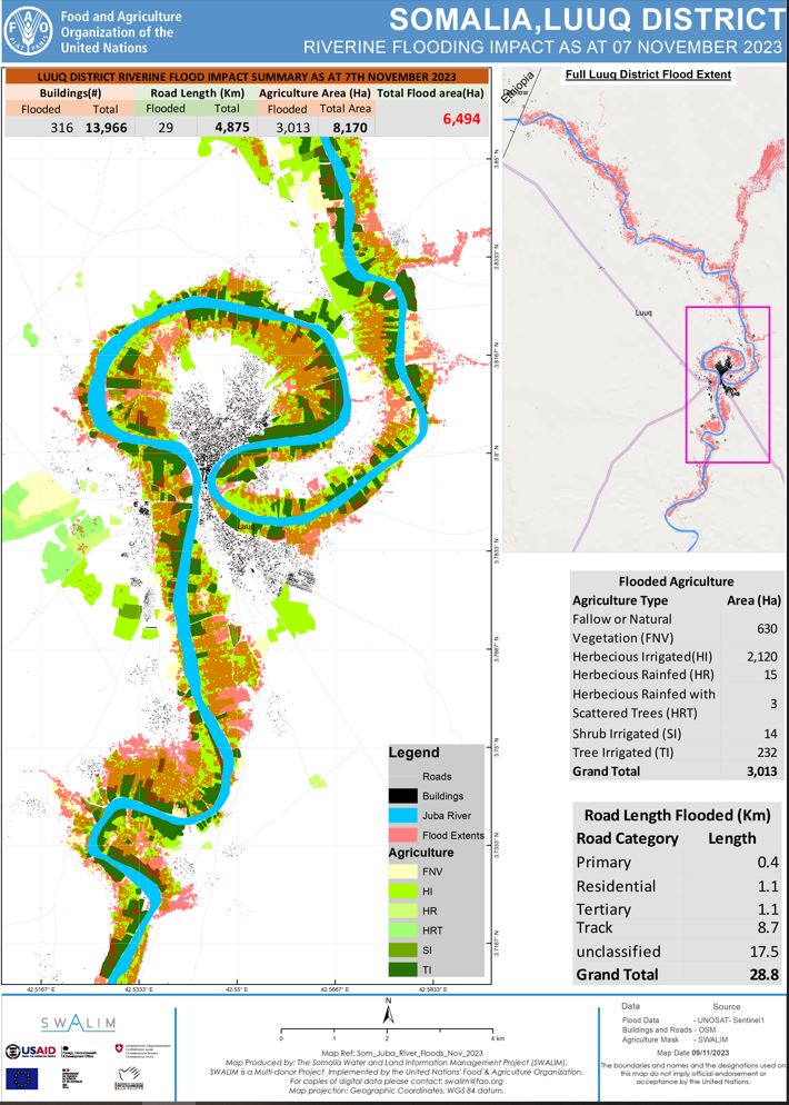
Luuq District Flood Impact Analysis Map - 09 November 2023
Utilizing the flood extent analysis conducted by UNOSAT on November 7th, 2023, it is evident that the onset of El Niño in the Horn of Africa has caused the flooding of 6,494 hectares of land in Luuq District. As per OSM data, this has resulted in the submersion of 316 buildings and 29 kilometers of roads. Additionally, 3,013 hectares of agricultural land, as per SWALIM agrimask, were submerged. This data emphasizes the immediate and significant repercussions of the ongoing El Niño event on the region.
Publication Type:
Map
Publication Date:
Author:
Corporate Author:
Beletweyne Riverine Flood Impact Map - Issued 21 November 2023
By 20th of November 2023, approximately 43,455 buildings; 968 Km of road and 28,418 Hectares of farms in Belet Weyne were flooded, as depicted on the map. The flood extents were identified through a comprehensive analysis, incorporating data from a modified Global Flood Model (GFM) based on Sentinel-1 image of November 20, 2023, visual interpretation of UNOSAT Beletweyne city extent data of November 16, 2023, and Sentinel-2 image of November 20, 2023. This inundation had a notable impact on the region. The data derived from this analysis offers a detailed overview of the extent and consequences of the flooding, facilitating a more informed understanding of the situation for effective response and mitigation efforts.
Publication Type:
Map
Publication Date:
Author:
Corporate Author:
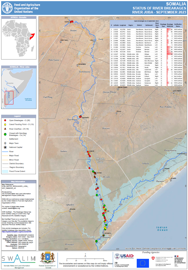
Status of River Breakages Along Juba and Shabelle Rivers - Issued October 2023
The Food and Agriculture Organization’s Somalia Water and Land Information Management (FAO SWALIM) Project, has finalized the analysis and mapping of the river breakages along the Juba and Shabelle rivers using very high resolution satellite imagery. Breakages identified in the map have been classified into four different categories; Open, Overflow, Canal Flooding Point and Closed with sandbags. A legend/Key for further explanation of the different types of breakages is provided.
A total of 170 Open points, 46 Canal flooding points, 152 Overflow points and 29 points closed with sandbags have been identified along the Shabelle River while 26 Open points, 10 Canal flooding points, 16 Overflow points and 14 points closed with sandbags have been identified along the Juba River which require immediate attention. Several other points, which are either potential or temporarily closed with sandbags, have also been identified.
The forecast ElNino season is likely to result to enhanced rainfall in Somalia and Ethiopian Highlands with high potential of flooding over the Juba and Shabelle rivers especially where open and potential points have been identified.
There is therefore an immediate need to close the open points and reinforce areas where there are weak river embankments. Intervening agencies are advised to take advantage of the current dry period until the rains start and carry out temporary or long term measures to close the river breakages. This will see a reduction of riverine flooding in case of heavy rains and consequently a massive reduction in economic losses to the country.
Publication Type:
Map
Publication Date:
Author:
Corporate Author:
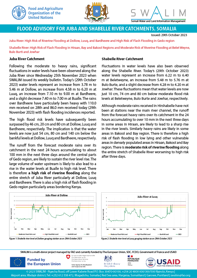
Somalia Flood Advisory for Juba and Shabelle Rivers - Issued 29 October 2023
Juba River: High Risk of Riverine Flooding at Dollow, Luuq, and Bardheere and High Risk of Flash Flooding in Gedo region
Shabelle River: High Risk of Flash Flooding in Hiraan, Bay and Bakool Regions and Moderate Risk of Riverine Flooding at Belet Weyne, Bulo Burti and Jowhar
Juba River Catchment: Following the moderate to heavy rains, significant fluctuations in water levels have been observed along the Juba River since Wednesday 25th November 2023 when SWALIM issued its weekly bulletin. Today’s (29th October 2023) water levels represent an increase from 3.78 m to 5.46 m at Dollow, an increase from 4.58 m to 6.20 m at Luuq, an increase from 7.10 m to 9.00 m at Bardheere, and a slight decrease 7.40 m to 7.00 m at Bualle. The rains over Bardheere have particularly been heavy with 110.0 mm received on 28th and 86.0 mm received today (29th November 2023) with flash flooding incidences reported.
The high flood risk levels have subsequently been surpassed by 46 cm, 20 cm and 80 cm at Dollow, Luuq and Bardheere, respectively. The implication is that the water levels are now just 54 cm, 80 cm and 140 cm below the bankful levels at Dollow, Luuq and Bardheere, respectively.
The runoff from the forecast moderate rains over its catchment in the next 24 hours accumulating to about 100 mm in the next three days around the central parts of Gedo region, are likely to sustain the river level rise. The large volume of water upstream is likely to also lead to a rise in the water levels at Bualle to high risk level. There is therefore a high risk of riverine flooding along the entire stretch of Juba River particularly at Dollow, Luuq and Bardheere. There is also a high risk of flash flooding in Gedo region particularly areas bordering Kenya.
Shabelle River Catchment:Fluctuations in water levels have also been observed along the Shabelle River. Today’s (29th October 2023) water levels represent an increase from 6.22 m to 6.40 m at Beletweyne, an increase from 5.48 m to 5.76 m at Bulo Burte, and a slight decrease from 4.28 m to 4.20 m at Jowhar. These fluctuations mean that water levels are now just 10 cm, 74 cm and 80 cm below moderate flood risk levels at Beletweyne, Bulo Burte and Jowhar, respectively.
Although moderate rains received in Hirshabelle have not been at stations near the main river channel, the runoff from the forecast heavy rains over its catchment in the 24 hours accumulating to over 10 mm in the next three days in some areas in Hiraan, are likely to lead to a sharp rise in the river levels. Similarly heavy rains are likely in some areas in Bakool and Bay region. There is therefore a high risk of flash flooding in low lying and other vulnerable areas in densely populated areas in Hiraan, Bakool and Bay region. There is moderate risk of riverine flooding along the entire stretch of Shabelle River worsening to high risk after three days.
Publication Type:
Flood Alert
Publication Date:
Author:
Corporate Author:
Somalia Rainfall Forecast – Issued 18 October 2023
Moderate to heavy rains expected over central and southwestern areas of the country during the coming week. The rains over Gedo and Bakool are likely to be observed in the first part of the forecasting period. The spatiotemporal distribution of the forecast rains is as below.
Heavy rainfall of above 100 mm is expected over Bakool, central parts of Gedo, southern parts of Hiraan and isolated areas in northern Galgaduud, localized areas in Galkayo in Mudug and southern parts of Sool. The rainfall over Ceel waaq in Gedo, Tayeeglow in Bakool, western parts of Bulo Burti in Hiraan and western parts of Ceel dheer in Galgaduud is likely to exceed 150 mm.
Moderate rainfall of between 50 and 100 mm is expected in Ceel Waaq and Garbahaarey districts in Gedo region, Baydhaba ditricts in Bay, Xudun, Ceel Barde, Tayeeglow districts in Bakool region, western parts of Bulo Burti district, northern parts of BeletWeyne district and western parts Jalalaqsi district in Hiraan. In the central parts of the country, rains of similar amounts are expected over Dhuusamareeb district and southern parts of Cadaado districts in Galgaduud region, Galkayo district, western part of Jariiban district and several isolated areas in Mudug region. Towards the north, comparatively moderate rainfall is also expected over Burtinle district in Nuugal region, southern parts of Qardho district in Bari region, central parts of Taleex districts in Sool region, southern parts of Las Anod, Buuhoodle district in Togheer, Ceel Afweyn town and it’s border areas with Erigavo in Sanaag region.
Light rainfall of below 50 mm is anticipated over the rest of the country with the exception of noncoastal areas of Awdal region, Hargeisa and Gebiley districts in Woqooyi Galbeed region, western parts of Bari region particularly over Bosasso district.
Publication Type:
Rainfall Forecast
Publication Date:
Author:
Corporate Author:
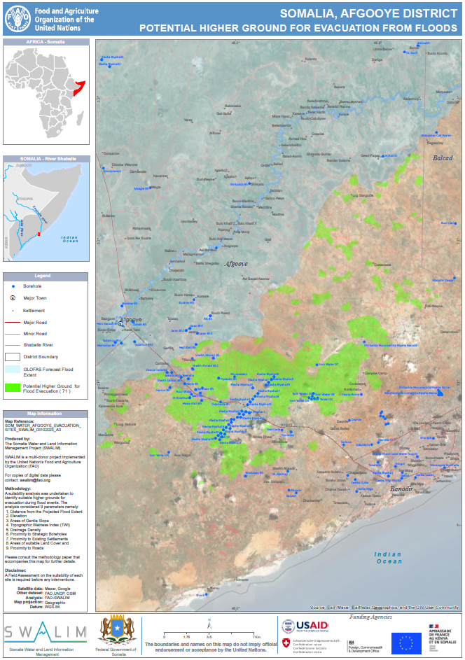
Higher Ground for Flood Evacuation in Afgooye District
Somalia grapples with the looming impacts of an impending El Niño, exacerbating the ongoing climate change challenges. Recurrent riverine and flash floods, particularly in urban centers are of significant concern. Urgent action is needed to prepare for and mitigate the forthcoming El Niño floods, aiming to safeguard lives and mitigate economic losses. Key to this strategy is proactive flood management, involving timely evacuations to higher ground. Identifying suitable elevated areas serves a dual purpose, ensuring safety and facilitating aid delivery. In this regard a rigorous GIS & RS methodology by SWALIM considered nine crucial factors, such as historical flood extent, elevation, slope, topographic wetness index, drainage density, strategic boreholes, settlements, land cover, and roads, to isolate higher grounds suitable for evacuation. The resulting maps show safe areas for evacuation in case of flooding, while exercising discretion considering factors like proximity to schools, healthcare facilities, pest prevalence and any other unforeseen factors
Publication Type:
Map
Publication Date:
Author:
Corporate Author:
Somalia Flood Advisory for Juba and Shabelle Rivers - Issued 20 October 2023
Moderate Risk of Flooding Along Juba River Particularly at Luuq and Bardheere
Heavy rains received over Luuq (80.5 mm), and moderate rains (26.2 mm) observed over Dollow
on 20th October 2023, coupled with moderate rains across the Ethiopian border have resulted to a sharp rise in river level at Luuq from 3.84 m on 18th to 5.6 m and at Dollow from 4.26 m on 19th to 4.78 m today. Added to previous light rains (14.1 mm) observed on 19th October at Luuq, moderate flood risk levels have been surpassed by 0.22 m and 0.1 m at Dollow and and Luuq, respectively. These localized rains also led to flashfloods affecting IDP camp at Luuq.
Moderate rains received over Beletweyne (38.5 mm) on 20th October 2023, and possibly more intense rains over the surrounding areas, coupled with moderate rains across the Ethiopian border have led to a noticeable rise in river level at Beletweyne from 4.95 m on 19th to 5.15 m today (20th October 2023).
The rainfall forecast for the next three days indicates moderate to heavy rain (50 – 150 mm) within the Somali-Ethiopia border particularly over upper parts of Gedo region, central parts of Bakool region and many parts of Hiraan region.
Although only light rains (4 mm) have been observed at Bardheere today (20th October), the forecast moderate rains in the 24 hours and coming days over upper parts of Gedo region, is likely to lead to further rise in the river levels with moderate risk of flooding along the entire Juba River stretch with the flood wave expected at Bardhere within 2 days. This is therefore an alert to trigger both riverine and flash floods anticipatory actions and to caution communities living along the Juba riverine areas particularly Luuq and Bardheere districts to be vigilant and heed to anticipatory measures as the river levels keep rising.
Although the risk of flooding along Shabelle River remains low today, the forecast moderate to heavy rains over Hiraan will lead to increase in river levels. If the heavy rains over Hiraan materialize, it may result in incidences of flash floods today and whose resultant run off and flood wave is expected to flow downstream towards Bulo Burte Burte and Jalalaqsi in the coming days. Additionally, the large volumes of water that was sighted at Limey district in Ethiopia which forms part of the upper catchment of Shabelle river, is likely to lead to a rise in water level at Beletweyne in two to three weeks.
Publication Type:
Flood Alert
Publication Date:
Author:
Corporate Author:
Pages
 RSS feed [compliant with the Agris AP] |
  Agris AP XML