Library Catalog
Latest Documents and Publications listed. Use search terms in the box below to find what you need
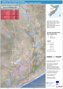
Xaaladda Jajabka-Gebiyada Webi Juba iyo Shabeelle – Sabteembar2016
Saadaasha roob-da’a Deryta 2016 (Oktoobar ilaa Nofeembar) waxay tilmaamaysa mid ah xaalad roobab caadi-u dhaw iyo caadi- ka hooseeya gudaha dooxooyinkaWebi Juba iyo Shabeelle. Hase ahaate, waxaa laga yaabaa in weli ay fatahaad ka dhacdo jiidda labada webi, gaar ahaan meelaha leh gebiyo webi oo furan/gebiyo webi oo tag daran, marka ay dhacdo qulqul webi oo kordhay.
SWALIM waxay casryeysay xaaladda jajabka-gebiyada webiga iyadoo khariidadeysay oo isticmaashay Masawir dayax-gacmeed aad iyo aad u bayaansan iyo Muuqal joog tirsiyeed (Digital Elevation Model (DEM)); iyo sidoo kale indha-indheyn goobta gegida meeshii ay suurtogal ah.
Saddex nooc oo jajab ayaa la aqoonsaday, oo lagu kala magacaabay: furan, suurogal, iyo xiran. Jajabka furan waa kuwa weli furan inta lagu guda jiro bisha Sabteemabar 2016. Jajabka suurogal waxay ka dhigan tahay meelo gebiyada webigu taag daran yihiin ama la kulmeen jajab waqti dhaw oo la soo dhaafay iyo meel wax yar ama hawlqabad aan laga samaynin. Tan waxaa ka mid ah jajab la xirxiray iyadoo la isticmaalayo kiishash camuud ah. Jajabyada la xirxiray waa kuwo markii hore furnaa balse ka dib la xirxiray iyadoo la isticmaalayo qalab makiinado culus ah, taasoo ka hortagtay fatahaad kale oo muddo gaaban iyo mid dheer.
Khariidadaha ku lifaaqan waxay muujinayaan jajabyada furan iyo suurogal ee jiidda labada webi. Marka la soo kobo, toddobo (7) meel oo ka furan jiidda Shabeelle iyo 63 jiidda Juba ayaa la aqoonsaday.Waxaa kale oo la aqoonsaday dhawr meelo kale oo in ay jajabaan suurogal tahay oo u baahan in la xoojiyo.
Hase ahaatee, waxaa mudan in la eego in habraacu uu si culus ugu tiirsan yahay masawirro dayax-gacmeed oo ay xadadan tahay ka soo xaqiijinta goobta dhulka. Mararka qaar gebi-jajabyada furan meesha waa laga saari karaa haddii masawirrada dayax-gacmeedku aysan bayaansanayn (tusaale, ded daruur culus) amase aan sinaba loo heli karin.
Kkariidadaha xaaladda gebi-jajabyada webiga oo macluumaad faahfaahsan leh, ayaa la soosaaray oo heer ballaaaran ah iyo nuqullo waraaqadag oo laga heli karaa xaafiisyada SWALIM. Macluumaadkaan waa sidoo kale laga heli karaa Habka macluumaadka SWALIM ee Halista Fatahaadda iyo Maareynta Jawaabta (http://systems.faoso.net/frrims/rivers/riverbreakages).
Publication Type:
Map
Publication Date:
Author:
Corporate Author:
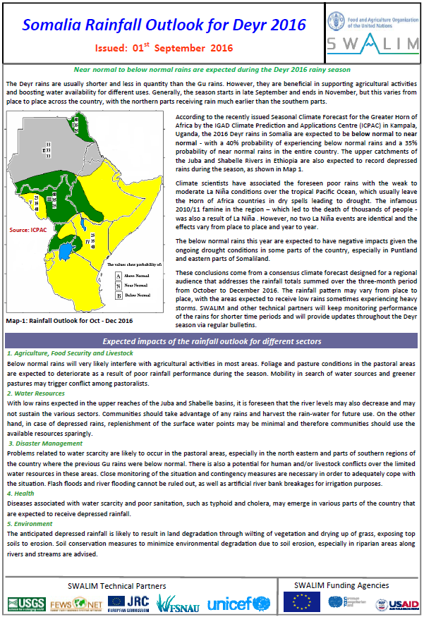
Somalia Deyr 2016 Rainfall Outlook
According to the recently issued Seasonal Climate Forecast for the Greater Horn of Africa by the IGAD Climate Prediction and Applications Centre (ICPAC) in Kampala, Uganda, the 2016 Deyr rains in Somalia are expected to be below normal to near normal - with a 40% probability of experiencing below normal rains and a 35% probability of near normal rains in the entire country. The upper catchments of the Juba and Shabelle Rivers in Ethiopia are also expected to record depressed rains during the season. Please see attached for more details.
Please note that this is a consensus forecast designed for a regional audience that addresses the rainfall totals summed over the three-month period from October to December, 2016. SWALIM and other technical partners will keep updating this forecast and monitoring performance of the rains for shorter time periods and will update you throughout the Deyr season via regular bulletins.
Publication Type:
Rainfall Outlook
Publication Date:
Author:
Corporate Author:
Muuqaalka roobda’a Soomaaliya ee Deyrta 2016
Sida dhawaan lagu sheegay saadaal cimilo xilliyeed ku saabsan Geeska Afrikada Weyn ee soo saartay xarunta IGAD ee Saadaasha Cimilada iyo Xarunta dabaqaadda (ICPAC) ee taal gudaha Kampala, Uganda, roobabka Deyrta sanadka 2016 ee gudaha Soomaaliya ayaa waxaa la filayaa inay noqdaan kuwa dhexeeya wax ka hooseeya caadi ilaa caadi –iyadoo qiyaasta la filayo ay tahay 40% roobab ka hooseeya caadi iyo qiyaastii 35% roobab ku dhaw caadi gudaha dalka oo idil. Biyo-qabatinka sare ee webiyada Juba iyo Shabeelle gudaha Itoobiya ayaa sidoo kale waxaa la filayaa in ay ka jirisayso hoos udhac roobab inta lagu guda jiro xilliga Deyrta. Fadlan eeg lifaaqqa si aad u aragto tafaasiil dheeraad ah.
Fadlan ogow in arrintani tahay saadaal la isla qaatay oo loogu talagaly goobjoogayaasha gobolka taasoo ka waaramaysa isugenta wadarta roobda’a, sanadka 2016, ee muddada saddexda bilood oo ka soo bilowda Oktoobar ilaa Disheembar. SWALIM iyo la-hawlwadaagta farsameed ee kale waxay joogto u cusuboonaysiin doonaan wararka saadaashan oo waxay kuurgali doonaan muddooyin waqtiga gaaban roobabku sida ay noqdaan xilliga Deyrta oo dhan waxaa ayna indin kula soo socodsiin doonaan wargeysyo caadi ah oo ay idiin soo gudbin doonaan.
Publication Type:
Rainfall Outlook
Publication Date:
Author:
Corporate Author:

Mapping Prosopis Juliflora in West Somaliland with Landsat-8 Satellite Imagery and Ground Information
Prosopis juliflora is a drought-tolerant fast-growing tree species originating from South and Central America with a high invasion potential in arid and semi-arid areas in Africa. It was introduced in Somaliland in the 1980s and is reported to have spread vigorously since.
Despite being recognized as a serious issue in the country, the actual scale of the problem is unknown. In this study, we mapped the species in a study area that includes the capital, Hargeisa, using Landsat 8 satellite imagery. During a field campaign in 2015, we collected canopy-level spectral signatures of P. juliflora and native trees to analyse the potential use of spectral data in discriminating the invasive species. P. Juliflora was found to be generally distinguishable because of its greater vigour during the dry season. We tested the accuracy of the random forest classifier and different classification set-ups, varying the spatial resolution (original 30m vs pan-sharpened 15m) and image acquisition dates (during the wet season, the dry season and a combination of the two). Best overall accuracy (84%) was achieved by using pan-sharpened data from the two seasons. About 30 years since its introduction, the invasive species was detected in 9% of the total investigated area with highest occurrence in the proximity of human settlements and along seasonal watercourses. © 2016 The Authors. Land Degradation and Development published by John Wiley & Sons, Ltd.
Publication Type:
Journal Article
Publication Date:
Author:
Gadain H.M., Alim M.S
Corporate Author:
SWALIM
Mapping Prosopis spp. with Landsat 8 Data in Arid Environments: Evaluating Effectiveness of Different Methods and Temporal Imagery selection for Hargeisa, Somaliland
Prosopis spp is a fast and aggressive invader threatening many arid and semi-arid areas globally.
The species is native to the American dry zones and was introduced in Somaliland for dune stabilization and fuel wood production in the 1970’s and 1980’s. Its deep rooting system is capable of tapping into the ground water table thereby reducing its reliance on infrequent rainfalls and near-surface water. The competitive advantage of Prosopis is further fuelled by the hybridization of the many introduced sub species that made the plant capable of adapting to the new environment and replacing endemic species. This study aimed to test the mapping accuracy achievable with Landsat 8 data acquired during the wet and the dry seasons within a Random Forest (RF) classifier, using both pixel- and object-based approaches. Maps are produced for the Hargeisa area (Somaliland), where reference data was collected during the dry season of 2015. Results were assessed through a 10-fold cross-validation procedure. In our study, the highest overall accuracy (74%) was achieved when applying a pixel-based classification using a combination of the wet and dry season Earth observation data. Object-based mapping were less reliable due to the limitations in spatial resolution of the Landsat data (15–30 m) and problems in finding an appropriate segmentation scale.
Publication Type:
Journal Article
Publication Date:
Author:
Gadain H.M., Wai-Tim, Leonardi, Rembold, Meroni
Corporate Author:
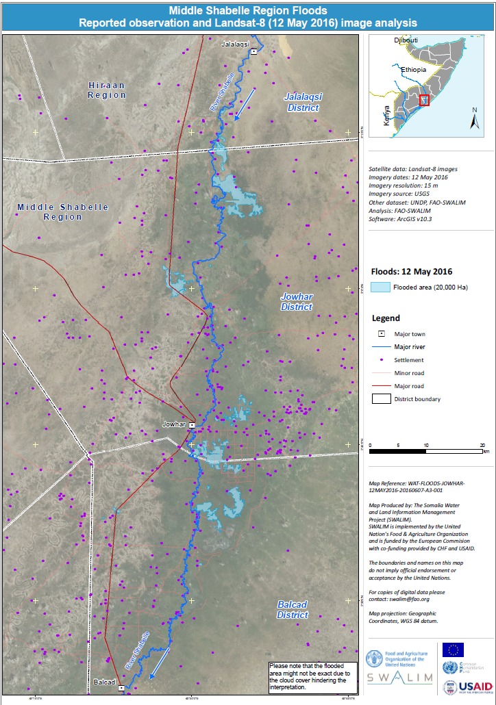
Daadadka Gobolka Shabeellaha Dhexe oo looga warbixiyay jeedaalinta iyo falanqaynta muuqaal sawirka
Xog ururin taan si toos ah ayaa looqoray iyadoo digital ah oo laga soo tafsiiray sawirka Landsat -8 iyo 12-kii May 2016 si loo muujiyo xadka bedka fatahaadda ay ka gaartey Jowhar. Fadlan la soco in laga yaabaa in aagga daadadku uusan sax ahayn sababta oo ah fasiraadda waxaa caqabadeeyey dedka daruurta.
Publication Type:
Map
Publication Date:
Author:
Corporate Author:
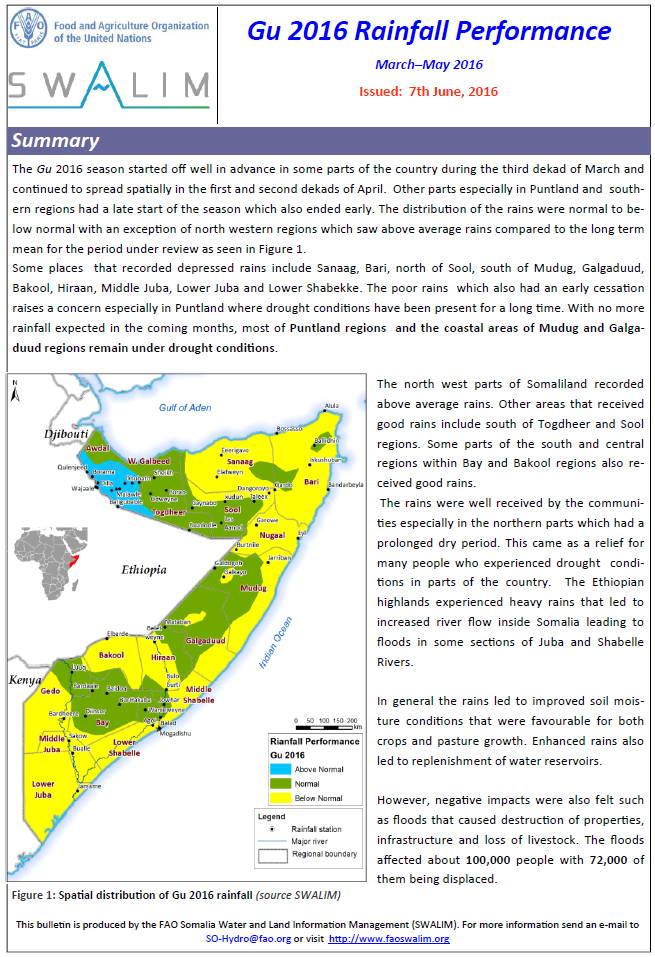
Sida uu noqday Roobka Gu 2016 gudaha Soomaaliya
Xilligii Gu'ga 2016 wuxuu si fiican uga bilawday goor hore qaybo ka mid ah dalka, gaar ahaan Soomaaliland, intii lagu jirey tobankii maalmood ee saddexaad ee bisha Maarso oo sii socday isagoo bed ahaan faafay intii lagu jirey tobanaadkii koowaad iyo labaad ee bisha Abriil. Qaybaha kale gaar ahaan gudaha Puntland iyo gobollada koonfureed wuxuu xilligu ka bilawday goor danbe kaas oo hadana dhamaaday goor hore.
Publication Type:
Rainfall Performance
Publication Date:
Author:
Corporate Author:
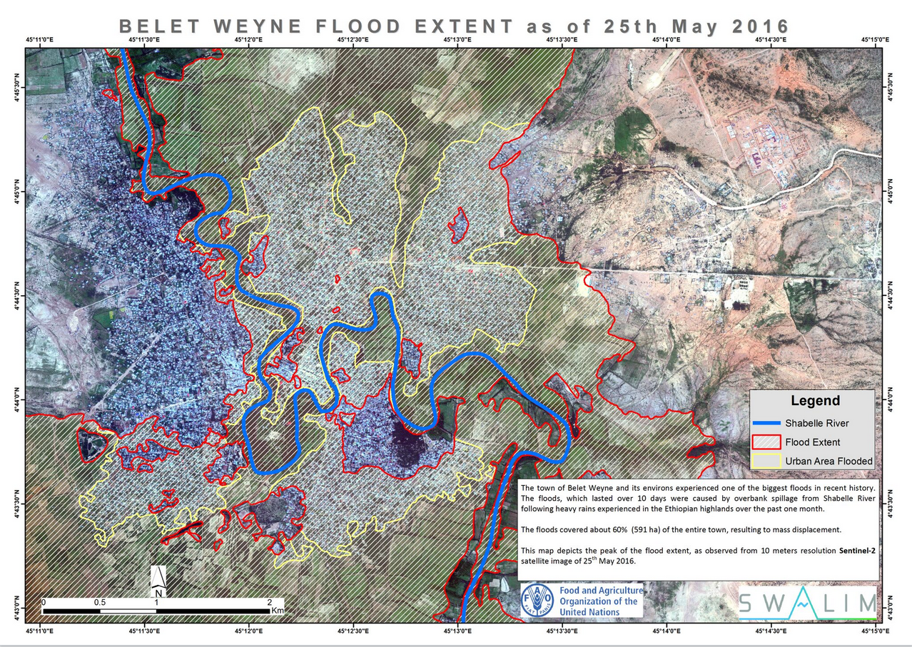
Belet Weyne flood map - June 2016
The town of Belet Weyne and its environs experienced one of the biggest floods in recent history. The floods, which lasted over 10 days were caused by overbank spillage from Shabelle River following heavy rains experienced in the Ethiopian highlands over the past one month. The floods covered about 60% (591 ha) of the entire town, resulting to mass displacement. This map depicts the peak of the flood extent, as observed from 10 meters resolution Sentinel-2 satellite image of 25th May 2016
Publication Type:
Map
Publication Date:
Author:
Corporate Author:
SWALIM Update Issue 11
We are pleased to share Issue 11 of our newsletter “SWALIM Update” for the period January 2016 – April 2016.
Publication Type:
Newsletter
Publication Date:
Author:
Corporate Author:
Somali Gu 2016 Rainfall Performance
The Gu 2016 season started off well in advance in some parts of the country during the third dekad of March and continued to spread spatially in the first and second dekads of April. Other parts especially in Puntland and southern regions had a late start of the season which also ended early. The distribution of the rains were normal to below normal with an exception of north western regions which saw above average rains compared to the long termmean for the period under review.
Some places that recorded depressed rains include Sanaag, Bari, north of Sool, south of Mudug, Galgaduud, Bakool, Hiraan, Middle Juba, Lower Juba and Lower Shabekke. The poor rains which also had an early cessation raises a concern especially in Puntland where drought conditions have been present for a long time. With no more rainfall expected in the coming months, most of Puntland regions and the coastal areas of Mudug and Galgaduud regions remain under drought conditions.
The north west parts of Somaliland recorded above average rains. Other areas that received good rains include south of Togdheer and Sool regions. Some parts of the south and central regions within Bay and Bakool regions also received good rains. The rains were well received by the communities especially in the northern parts which had a prolonged dry period. This came as a relief for many people who experienced drought conditions in parts of the country. The Ethiopian highlands experienced heavy rains that led to increased river flow inside Somalia leading to floods in some sections of Juba and Shabelle Rivers.
In general the rains led to improved soil moisture conditions that were favourable for both crops and pasture growth. Enhanced rains also led to replenishment of water reservoirs. However, negative impacts were also felt such as floods that caused destruction of properties, infrastructure and loss of livestock. The floods affected about 100,000 people with 72,000 of them being displaced.
Publication Type:
Rainfall Performance
Publication Date:
Author:
Muchiri P.
Corporate Author:
Pages
 RSS feed [compliant with the Agris AP] |
  Agris AP XML