Library Catalog
Latest Documents and Publications listed. Use search terms in the box below to find what you need
Rainfall Forecast for SIRA II project Area – Issued 03 June 2024
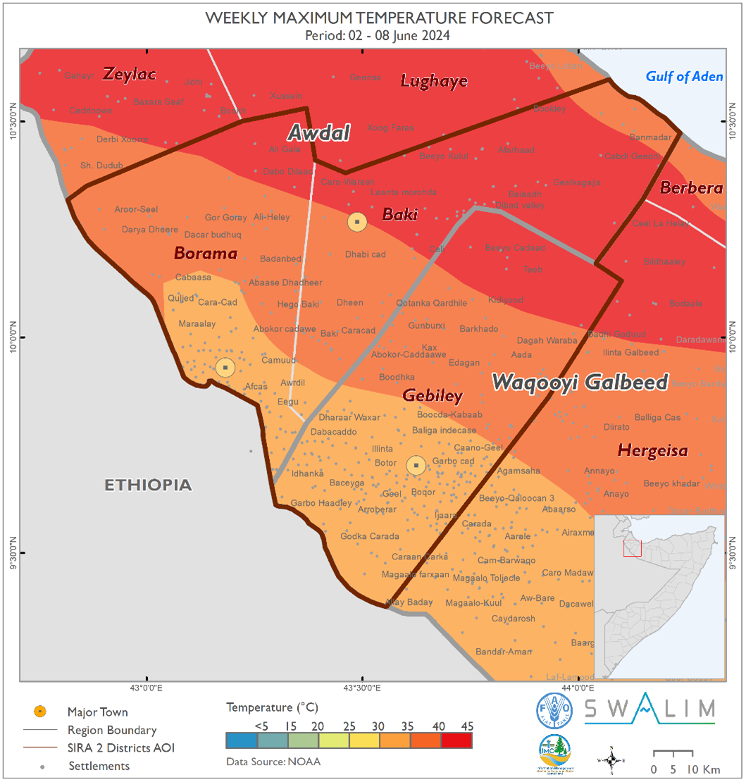
This week marks the end of the Gu rains across the project area, ushering in the Hagaa season. The forecasted dry conditions may benefit agropastoral activities such as weeding in the Awdal region, which includes Baki and Borama districts. Here, above-normal Hagaa conditions are expected to maintain soil moisture, supporting continued crop and fodder production. However, the anticipated hot and dry air mass over the northern parts of the project area this coming week may lead to severe evapotranspiration, posing significant challenges to agropastoral activities. As we transition into the Hagaa season, it is crucial to implement measures for water conservation and the preservation of existing crops and fodder.
Publication Type:
Rainfall Forecast
Publication Date:
Author:
Corporate Author:
Somalia Rainfall Forecast – Issued 09 May 2024
During the week between 8 and 14 May 2024, and based on NOAA-NCEP GFS, light rains are expected over most parts of the country with moderate rains likely over Lower Shabelle and coastal parts of Lower Juba. Based on climatology, the observed and anticipated northward spread of the rains into the central and northern parts of Somalia is favored by the northward movement of the Inter Tropical Convergence Zone (ITCZ). The ITCZ's arrival will attract low-level incursions of precipitable water inland, mitigating prolonged dry conditions over Bari.
After the prolonged stagnation, the Madden Julian Oscillation (MJO) index has now propagated eastwards from our region. This is likely to favor a week-long break from the moderate to heavy rains received in the region. The forecast return of the index is likely to drive moderate to heavy rains from 15 May 2024. The forecast rains in the third week of May (15 – 21 May) are associated with better skill and reliability. The rains are likely to decrease thereafter marking the end of the Gu season particularly in Jubaland, South West and Hirshabelle. The effect of the sea surface temperature (SSTs) difference between the eastern and western Indian Ocean on the rains cannot also be ruled out. According to Australian Bureau of Meteorology, the warming in the Indian Ocean indicates a likelihood of positive Indian Ocean Dipole (IOD) developing earlier than usual. However, it has been reported that MJO events occurring during positive IOD have weaker convection and less organized wind anomalies which restricts local low-level moisture transport thus explaining the low likelihood of very extreme rainfall this season. Week by week and day-to-day monitoring is therefore advised.
The temporal and spatial distribution of the forecast rainfall according to NOAA-NCEP GFS are as follows:
• Moderate cumulative rainfall between 50 mm and 100 mm is likely over Lower Shabelle region particularly Barawe, Marka and southern parts of both Sablaale and Kurtunwaarey districts. Similar moderate rains are likely over the coastal parts of Lower Juba region particularly Badhadhe, Kismaayo and Jamaame districts. The rains, according to ICPAC weekly forecast may be more intense (100 mm to 200 mm) over Hirshabelle region including the Shabelle River catchment within the country and upstream in Ethiopia.
• Light cumulative rainfall of less than 50 mm is forecast across the most other parts of the country particularly in Woqooyi Galbeed, Sanaag, Nugaal, Mudug, Hirshabelle, Bay, Bakool, Middle Shabelle, and Middle Juba regions.
• Dry conditions are particularly likely over the Zeylac, Lughaye and Baki districts in Awdal region; Berbera district and eastern parts of Hargeisa district in Waqooyi Galbeed region; Odweine, Burao and Buhoodle districts in Togdheer region; Ceel Afweyn district in Sanaag region; and Bossaso, Qandala, Calula, Isku-shuban and Bandarbeyle districts in Bari region. Towards the central part of the country dry conditions are also expected over western parts of both Burtinle and Garowe and coastal parts of Eyl district in Nugaal region; Xarardheere, Hobyo and Jariiban districts in Mudug region; and Ceel Buur and Cadaado districts in Galgaduud region. Dry conditions are also expected western parts of Afmadow district in Lower Juba region; Doolow and Belet Xaawo districts, western parts of both Luuq and Garbahaarey districts and southern parts of Baardheere district in Gedo region; Saakow district in Middle Shabelle region; Xudur in Bakool region; Wanla Weyn district in Lower Shabelle region; and western parts of Jowhar district in Middle Shabelle region.
Publication Type:
Rainfall Forecast
Publication Date:
Author:
Corporate Author:
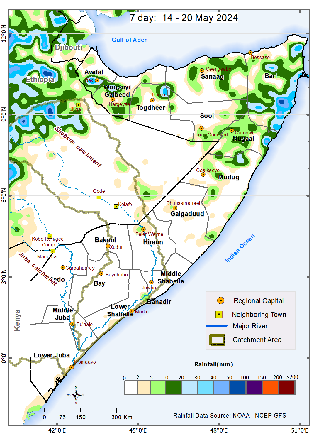
Somalia Rainfall Forecast – Issued 14 May 2024
According to NOAA-NCEP GFS, during the week between 14 and 20 May 2024, light to moderate rain are expected in Puntland and Somaliland with dry conditions likely throughout central and southern parts of the country. This general northward spread of the rains is favored by the northward presence of the Inter Tropical Convergence Zone (ITCZ).
As had been anticipated, the eastward propagation of the Madden Julian Oscillation (MJO) index from the Indian Ocean favored the general dry conditions during the last week (7 – 13). While the index is presently within the region, none of the weather forecast models has captured its effect on rainfall during this forecast week. Given that its 5-day forecast position is associated with better skill and reliability, there is still a likelihood of moderate to heavy rains towards the end of the forecast week i.e., from around 18 May 2024. Day-to-day monitoring is therefore advised. The rains are likely to decrease thereafter marking the end of the Gu season particularly in Jubaland, Southwest and Hirshabelle.
The temporal and spatial distribution of the forecast rainfall are as follows:
Moderate cumulative rainfall between 50 mm and 100 mm is likely over northwestern parts of Bandarbeyla district in Bari region. These rains are likely to be received between 14 and 16 May 2024.
Light cumulative rainfall of less than 50 mm is forecast over several areas in both Bandarbeyla and Iskushuban districts, northern parts of Qardho district, and southern parts of both Qandala and Caluula districts in Bari region; Garowe district, coastal parts of Eyl district, and northern parts of Burtinle district in Nugaal region; eastern and western parts of Ceerigaabo district, western parts of Ceel Afweyn district, and northern parts of Laasqoray district in Sanaag region; southern parts of Laas Caanod district and northern parts of Caynabo district in Sool region; northern parts of Burco district and western parts of Owdweyne district in Togdheer region; Gebiley district and northern and southern parts of Hargeysa district, and southern parts of Berbera district in Woqooyi Galbeed; and Borama and central and southern parts of Baki district, northern parts of Zeylac district in Awdal region. Rains of similarly trace amounts are also likely over isolated areas of Hobyo district, northern parts of Jariiban district, eastern parts of Gaalkacyo district in Mudug region; western parts of Dhuusamarreeb district in Galgaduud region; Belet Weyne town in Hiraan region; eastern parts of Afgooye district in Lower Shabelle region; and Banadir region.
Dry conditions (rainfall less than 1 mm) are likely in most areas in the following regions: Lower Juba, Middle Juba, Gedo, Bay, Bakool and Middle Shabelle region. Dry conditions are also likely to prevail over Sablaale, Baraawe, Kurunwaarey, Qoryooley, Wanla Weyn districts and central and western parts of Afgooye district in Lower Shabelle region; Jalalaqsi, Bulo Burte and most other parts of Belet Weyne district in Hiraan region; Ceel Dheer, Ceel Buur, Cabudwaaq and Cadaado districts and most other parts of Dhuusamarreeb district in Galgaduud regiuon; Xarardheere district, vast areas of Hobyo district, most other parts of both Jariiban and Gaalkacyo districts in Mudug region. Towards the northern parts of the country, dry conditions are also likely over inland parts of Eyl district, and most other parts of Burtinle district in Nugaal region; Bossaso district, most other parts of Qardho, Qandala and Caluula districts in Bari region; most other parts of Ceerigaabo, Laasqoray and Ceel Afweyn district in Sanaag region; Xudun, Taleex, and most other parts of both Laas Caanood and Caynabo districts in Sool region; Buhoodle and Sheikh districts and most other parts of Burco and Owdweyne districts in Togdheer region; central parts of Hargeysa district, and most other parts of Berbera district in Woqooyi Galbeed; and Lughaye, northern parts of Baki district, and southern parts of Zeylac district in Awdal region.
Publication Type:
Rainfall Forecast
Publication Date:
Author:
Corporate Author:
Tropical Storm Ialy Advisory - English - Issued 21 May 2024
This Tropical Storm Advisory is applicable to Lower Juba and Middle Juba regions, particularly Badhaadhe, Kismaayo and Jilib Districts and the surrounding areas where moderate localized rains, strong winds and large ocean waves may be observed.
Tropical Storm Ialy started off as a Disturbance on 14 May 2024 growing into a Moderate Tropical Storm on 16 May and into a Severe Tropical Storm on 19 May. It is forecast to reduce in intensity in the next 36 hours (about 1 and a half days) as it approaches the Equator to a just a normal low-pressure system without making landfall in any part of the East African coastline. However, the area of influence may stretch beyond the Equator resulting in strong surface wind, large ocean waves and moderate rainfall over the coastal and nearby inland areas of Badhaahde, Kismaayo and Jilib Districts.
Therefore, a MODERATE-RISK WARNING FOR STRONG WINDS, LARGE OCEAN WAVES AND FLASH FLOODS is in effect for Badhaahde, Kismaayo and Jilib Districts and the surrounding areas due to spillover effects of Tropical Storm Ialy.
Publication Type:
Storm Alert
Publication Date:
Author:
Corporate Author:
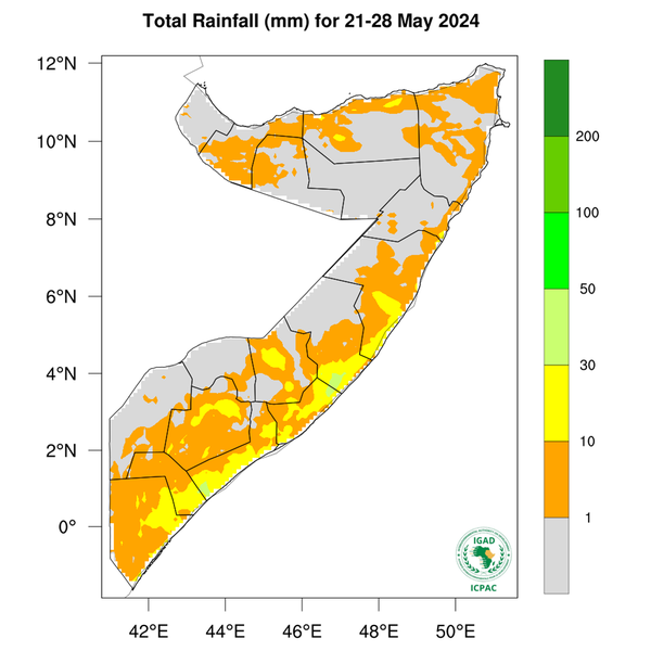
Somalia Rainfall Forecast – Issued 22 May 2024
According to ICPAC, during the week between 21 and 28 May 2024, dry conditions and light rainfall is expected in most inland parts of the country with chances of moderate rains over coastal parts of the southern regions. These forecast coastal rains seem to be driven by the warming in the Indian Ocean.
As the Inter Tropical Convergence Zone (ITCZ) shifts further north, its impact on the Gu rains across the country begins to diminish ushering in Hagaa season. However, given that today’s Madden Julian Oscillation’s (MJO) 3-day forecast position is associated with better skill and reliability, there is still some likelihood of moderate rains before the end of the month. Day-to-day monitoring is therefore advised.
The temporal and spatial distribution of the forecast rainfall (Map 1) is as follows:
Light cumulative rainfall of less than 50 mm is forecast over most coastal parts of Somalia including; Berbera district in Woqooyi Galbeed region; northern parts of Ceel Afweyn, Ceerigaabo and Laasqoray districts in Sanaag region; Bossaso, Qandala, Banderbeyla, Caluula and Iskushuban districts in Bari region; Eyl district in Nugaal region; Jariiban, Xarardheere and Hobyo districts in Mudug region; Ceel Dheer in Galgaduud region; Adan Yabaal, Cadale and Balcad districts in Middle Shabelle region; Afgooye, Qoryooley, Kurtunwaarey and Sablaale districts in Lower Shabelle region; Mogadishu in Banadir region; Jilib district in Middle Juba region; Jamaame, Kismayo and Badhaadhe districts in Lower Juba region. Similarly, other inland districts that are likely to receive light rainfall include Hargeisa and Gebiley districts in Woqooyi Galbeed region; Odweyne district in Togdheer region; Belet Weyne district in Hiraan region; Tayeeglow district in Bakool region; Baydhaba and Qansax Dheere districts in Bay region; and Afmadow district in Lower Juba region.
Dry conditions (including rainfall less than 1 mm) are likely in most areas of Awdal and Sool regions; Burao district in Togdheer region; southern parts of Ceel Afweyn and Ceerigaabo districts in Sanaag region; Qardho district in Bari region; Garowe district in Nugaal region; western parts of Burtinle distric in Nugaal region; Gaalkacyo and Galdogob districts in Mudug region; Caabudwaaq and western parts of Cadaado district in Galgaduud region; Ceel Barde, Xudur, Rab Dhuure and Waajid districts in Bakool region; Doolow, Belet Xaawo and Ceel Waaq districts in Gedo region; and Caluula district in Bari region.
Tropical Storm Ialy Advisory
Tropical Storm Ialy (Map 2) started off as a Disturbance on 14 May 2024 growing into a Moderate Tropical Storm on 16 May and into a Severe Tropical Storm on 19 May. It is forecast to reduce in intensity in the next 24 hours as it approaches the Equator to just a normal low-pressure system without making landfall in any part of the East African coastline. However, the area of influence may stretch towards the Equator resulting in strong surface wind, large ocean waves and moderate rainfall over the coastal and nearby inland areas of Badhaade, Kismaayo and Jilib Districts.
Publication Type:
Rainfall Forecast
Publication Date:
Author:
Corporate Author:
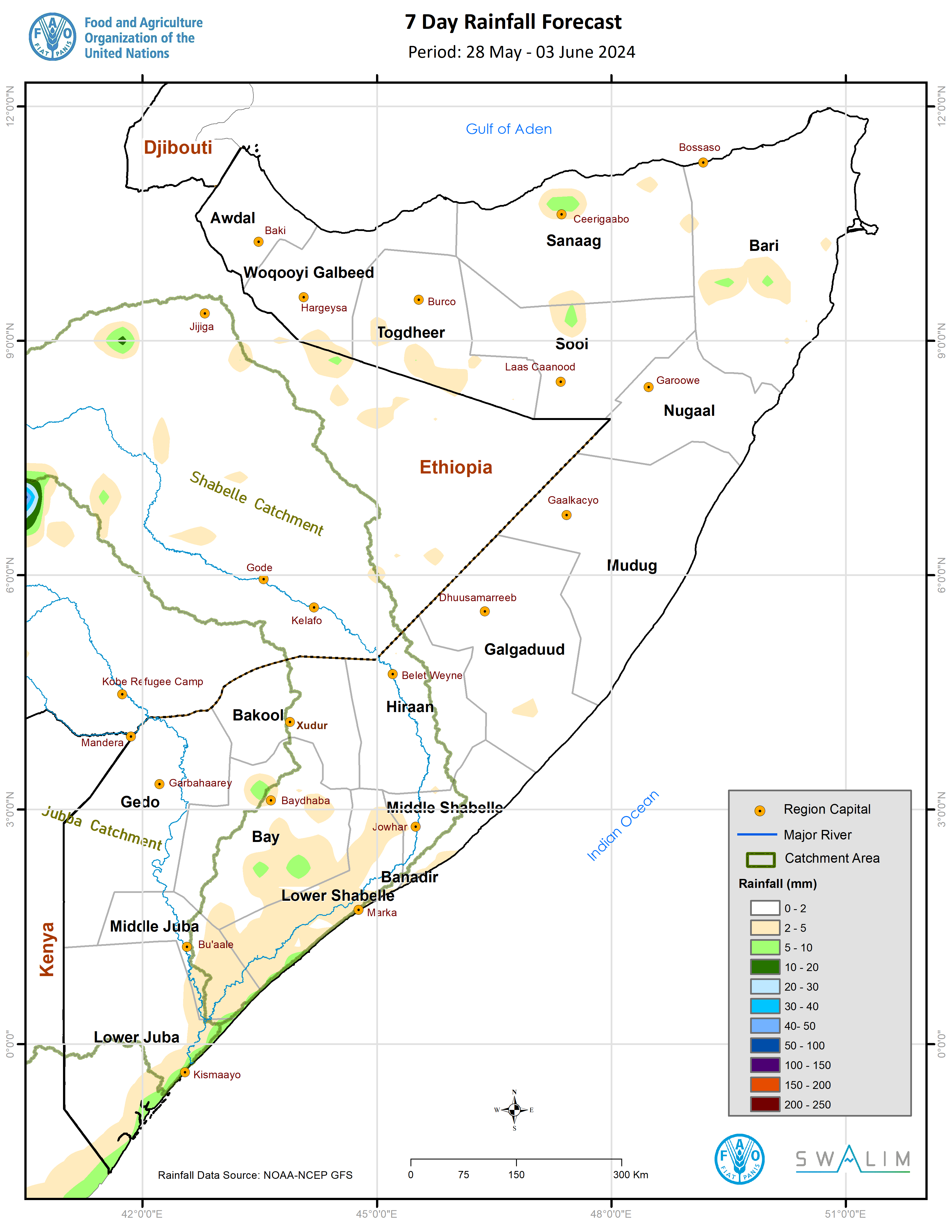
Somalia Rainfall Forecast – Issued 29 May 2024
Weekly Rainfall Forecast:
According to ICPAC, during the week between 28 May to 3 June 2024, dry conditions are expected in most inland parts of the country with chances of light rainfall over coastal parts of the southern regions (Map 1). Given that this forecast week represents the transition out of the Gu season, it is important to mention that, according to ICPAC, above-normal Hagaa rainfall conditions are expected over Lower Juba, Middle Juba, Lower Shabelle, and Awdal regions. On the other hand, Togdheer and Sool-Sanaag regions are likely to experience drier-than-normal Hagaa conditions.
Evolution of Rainfall Drivers:
As the Inter Tropical Convergence Zone (ITCZ) shifts further north, its impact on the Gu rains across the country begins to diminish ushering in Hagaa season. As the ITCZ shifts further north, a low-pressure system will be set up in Indian Sub-continent triggering the Southwest monsoon winds. As the winds blow from land into the Ocean (westerly land breeze) between 3:00 am and 9:00 am in the morning they converge with the prevailing easterly winds aiding lifting of warm and moist air causing the morning showers observed and forecast over the coastal parts of southern regions including Banadir. The forecast shift in the position of Madden Julian Oscillation’s (MJO) index from the Indian Ocean re-affirms the forecast dry conditions inland and a reduction in the intensity of the morning coastal showers in the coming days. This shift is also likely to lead to a reduction in the cyclonic activity in the southwestern Indian Ocean and favor such disturbances in the northern Indian Ocean particularly Bay of Bengal.
Publication Type:
Publication Date:
Author:
Corporate Author:
Somalia Rainfall Forecast – Issued 02 May 2024
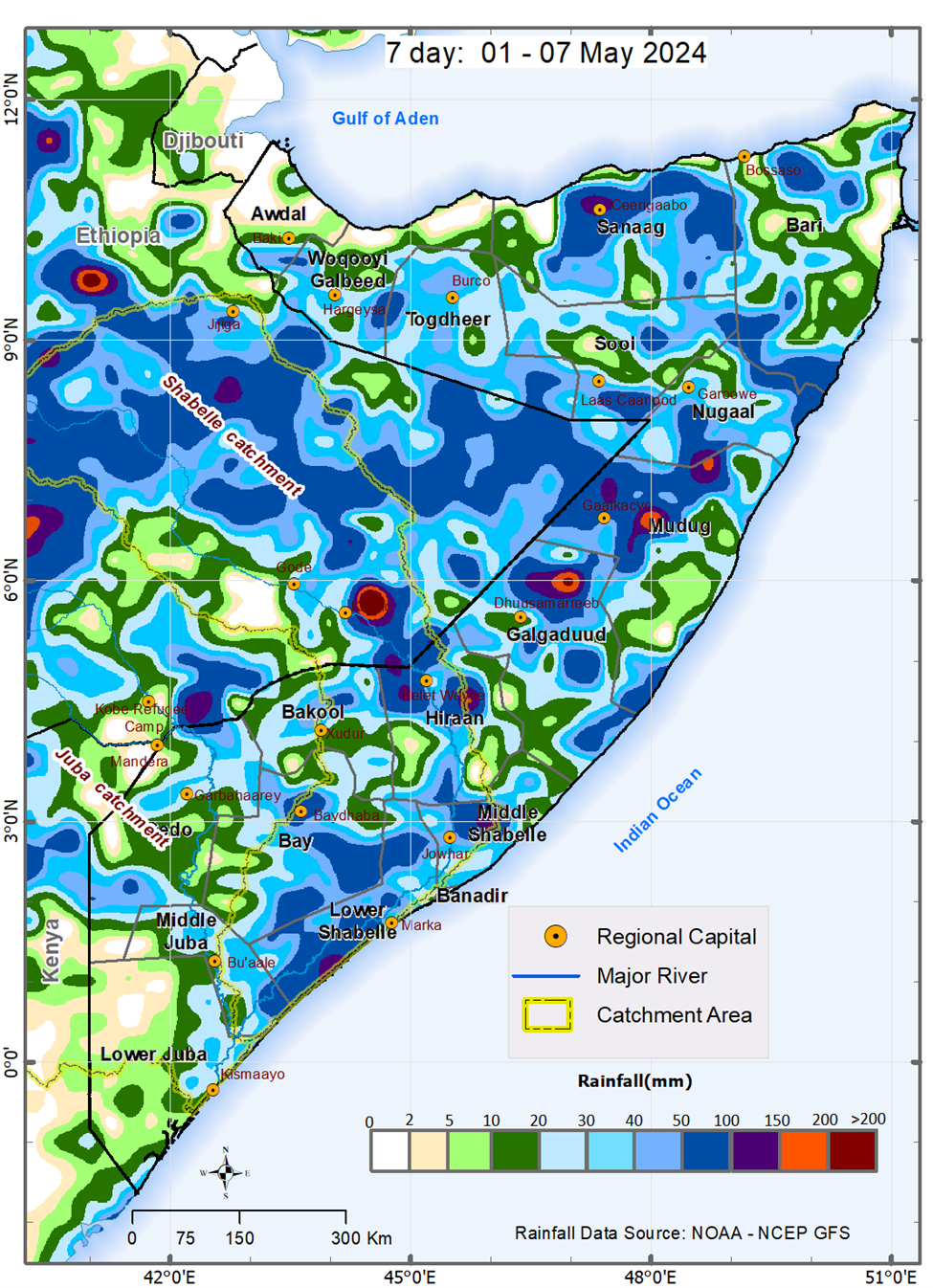
During the week between 1 and 7 May 2024, and based on NOAA-NCEP GFS, light to moderate rain is expected over most parts of the country, with chances of heavy rain and flash floods expected in some areas of Hiraan, Galgaduud and Mudug regions. Based on climatology, the observed and anticipated northward spread of the rains into the central and northern parts of Somalia is favored by the northward movement of the Inter Tropical Convergence Zone (ITCZ). The arrival of the ITCZ will attract low-level incursions of precipitable water inland thereby mitigating the prolonged dry conditions over Bari.
The Madden Julian Oscillation (MJO) index, which ideally is expected to propagate eastwards covering the entire globe in 40 – 60 days, and therefore anticipated to be present over 1 of the 8 regions for about one week, has stagnated over the eastern Indian Ocean for about two weeks. This is favoring the observed moderate to heavy rains in Somalia and the extremely heavy rains elsewhere within the Greater Horn of Africa (GHA). The location of the index since 25 April shows improvement in strength and increase in forecast skill and reliability. As of 1 May, the index is at region 4 and is forecast to be back to region 2 within the next two weeks. Its lagged effect favors a continuation of moderate rains in the first half of the forecast period (1 – 4 May) with expected possible resumption of heavy rainfall activity in the second week of May. The favorable effect of the Indian Ocean Dipole (IOD) on the rains cannot also be ruled out. According to Australian Bureau of Meteorology, the warming in the Indian Ocean indicates a likelihood of positive IOD developing earlier than usual.
Although Somalia is not within the direct path of the current tropical disturbance in the western Indian Ocean, the low pressure associated with it may lead to sucking of moisture causing generally less rainfall over the southern part of the country. Week by week and day-to-day monitoring is therefore advised.
The temporal and spatial distribution of the forecast rainfall (Map 1) are as follows:
• Very heavy cumulative rainfall between 150 mm and 200 mm is likely over some isolated areas in central and eastern parts of Dhuusamareeb district in Galgaduud region, northern parts of Hobyo district, southern parts of Gaalkacyo district, northern parts of Jaariban district in Mudug region, and southern parts of Belet Weyne district in Hiraan region. The rains over isolated areas in the above places particularly in the central and eastern parts of Dhuusamareeb district may be very intense leading to more than 200 mm in cumulative terms and are likely to fall between 1 and 3 May 2024 with likelihood of flash flooding in vulnerable spots including flat and crowded human settlements.
• Heavy cumulative rainfall between 100 mm and 150 mm is likely over the rest of the other areas in the following places: central and eastern parts of Dhuusamareeb district in Galgaduud region, northern parts of Hobyo district, southern parts of Gaalkacyo district, northern parts of Jaariban district, and eastern parts of Galdogob district in Mudug region, and western and southern parts of Belet Weyne district in Hiraan region. Similarly heavy rains are likely over northern parts of Ceerigaabo district in Sanaag region, southern parts of Burtinle district in Nugaal region, eastern parts of Jowhar district in Middle Shabelle region and Baraawe district in Lower Shabelle.
• Moderate cumulative rainfall between 50 mm and 100 mm is likely over the rest of the areas in Dhuusamareeb district, and eastern parts of both Ceel Buur and Ceel Dheer districts in Galgaduud region, Gaalkacyo and Galdogob district and coastal parts of Xaradheere district in Mudug region, and Belet Weyne district and northern parts of Bulo Burte district in Hiraan region, northern parts of both Ceerigaabo and Laas Qoray districts in Sanaag region, Burtinle district and northern parts of Eyl district in Nugaal region, Jowhar district in Middle Shabelle region, Baraawe, Sablaale, Kurtunwaarey and Wanla Weyne districts in Lower Shabelle region. Similar rains are likely over Qandala district and southern parts of both Qardho and Bandarbeyla districts in Bari region, central parts of Hargeisa-Odweyne districts’ border, Buhoodle district in Togdherregion, Las Anod and Xudun-Taleex districts’ border in Sool region. Rains of similarly moderate intensy are likely over some areas in South West State including Buur Hakaba district and central parts of Baydhaba district in Bay region, central parts of Bakool region and central parts of Bardheere district in Gedo region.
• Light cumulative rainfall of less than 50 mm is forecast over most of the following regions: Lower Juba, Middle Juba, Bay, Bakool, Gedo, Togdheer, Woqooyi Galbeed, Bari, Nugaal, coastal parts of Mudug, southern parts of Sanaag, central parts of Sool, and southern parts of Awdal.
• Dry conditions are likely to prevail over southwestern, northwestern, and northeastern parts of the country. These include western parts of Afmadow district in Lower Juba region, Zeylac and Lughaye districts in Awdal region, Berbera district in Woqooyi Galbeed region, Caluul and Iskushuban districts in Bari region.
Publication Type:
Rainfall Forecast
Publication Date:
Author:
Corporate Author:
Somalia Rainfall Forecast – Issued 04 April 2024
During the week from the 2nd to 8th April 2024, the onset of the Gu rains is likely to be observed with moderate rainfall expected over some places in the following regions: Lower Juba, Gedo, Bay, Bakool, Lower Shabelle, Awdal, and Woqooyi Galbeed regions. Dry conditions are likely to be observed over most parts of Galmudug and Puntland.
The cloudiness and rains in the northern parts of the country are likely to result from the north easterly winds being orographically lifted by the east-west oriented mountain ranges. The anticipated progression of the rains from Jubaland into South West is favored by the northward movement of the Inter Tropical Convergence Zone (ITCZ).
Heavy cumulative rainfall between 100 m and 150 mm is expected over some places in the western parts of Afmadow district in Lower Juba region, the northern parts of Qansax Dheere district in Bay region, and western parts of Rab Dhuure in Bakool region. It is noteworthy that such projected heavy rains will fall within the catchment of Juba River.
Moderate cumulative rainfall between 50 mm and 100 mm is forecast over most places in the western parts of Afmadow district in Lower Juba region, central parts of Baardheere district, western parts of Ceel Waaq district, eastern parts of Garbahaarey district and northern parts of Luuq district in Gedo region, northern parts of Qansax Dheere district in Bay region, western parts of Rab Dhuure district in Bakool region, and western parts of Sablaale and Baraawe districts in Lower Shabelle region. In the north, similarly moderate rains are anticipated over most places in Borama district and southern parts of Baki district in Awdal region, Gebiley district and western parts of Hargeysa district in Woqooyi Galbeed region, and northern parts of Ceerigaabo district in Sanaag region.
Light cumulative rainfall of less than 50 mm is forecast over most places in Middle Juba and Middle Shabelle regions including Banadir, most of the other places in Lower Juba region including Jamaame district, most of the other places in Gedo region including Belet Xaawo and Doolow districts, most of the other places in Bay region including Baydhaba district and western parts of Buur Hakaba district, most of the other places in Bakool region including Waajid, Xudur and Tayeeglow districts and central and western parts of Cee Barde district, and most of the other places in Lower Shabelle including Kurtunwaarey and Qoryooley districts. Light rainfall is also expected over most parts of Hiraan region and coastal parts of both Ceel Dheer district in Galgaduud region and Xarardheere district in Mudug region. In the north, rainfall of similar amount is expected over most of the other places in Borama and southern parts of both Baki and Zeylac districts in Awdal region, most of the other places in Gebiley and Hargeysa districts in Woqooyi Galbeed region, and most of the other northern parts of both Ceerigaabo and Cel Afweyn districts in Sanaag region.
Dry conditions are likely to prevail over vast areas in the north including Bari, Sool, and Nugaal regions, Laasqoray district and central and southern parts of both Ceel Afweyn and Ceerigaabo districts in Sanaag region, Lughaye district and northern parts of both Zeylac and Baki districts in Awdal region, and Berbera district in Woqooyi Galbeed region. Dry conditions are also expected in the central parts of the country including most inland parts of Mudug region, Cabudwaaq, Cadaado, and Dhuusamareeb districts in Galgaduud region, central and northern parts of Belet Weyne district in Hiraan region, and the areas in Afgoye-Wanla Weyn districts’ boundary in Lower Shabelle.
Publication Type:
Rainfall Forecast
Publication Date:
Author:
Corporate Author:
Somalia Rainfall Forecast – Issued 10 April 2024
During the week between 10 and 16 April 2024, and based on NOAA-NCEP GFS, light to moderate rains is predicted over several isolated areas in Jubaland, Southwest and Galgaduud with dry conditions in Somaliland and Puntland. It is important to point out that ICPAC’s forecast based on WRF anticipates wetter conditions particularly over Gedo region. The chances of wetter conditions might be supported by the prolonged presence of MJO index over the Indian Ocean region. This stagnation of the MJO over this region indicates the presence of heavy rainfall producing conditions. The prevalent dry conditions over most parts of Puntland are likely to be driven by the low-level easterly winds blowing parallel to the coastline and therefore limiting the injection of water vapor inland. The anticipated spread of the rains from Jubaland into South West and possibly Galgaduud is favored by the northward movement of the Inter Tropical Convergence Zone (ITCZ).
The temporal and spatial distribution of the forecast rainfall are as follows:
Heavy cumulative rainfall between 100 m and 150 mm is likely over some isolated areas over Jubaland. Based on consensus such heavy rainfall is anticipated over Kismaayo district in Lower Juba region and, Bardheere and Ceel Waaq districts in Gedo region. According to ICPAC’s forecast, the rains over Ceel Waaq district might be particularly heavy accumulating to above 150 mm. It is noteworthy that such projected heavy rains will fall within the catchment of Juba River.
Moderate cumulative rainfall between 50 mm and 100 mm is likely over very isolated areas in Jubaland, Dinsoor and Qansax Dheere districts in Bay region, Sablaale, Baraawe, Wanla Weyne and Afgoye districts in Lower Juba region, Jowhar and Balcad districts in Middle Shabelle region.
Light cumulative rainfall of less than 50 mm is forecast over most other places in Jubaland, South West, Hirshabelle and Galgaduud. Isolated light rains are also likely over some areas in the northern parts of the country particularly the windward sides of the mountainous and hilly areas. Such rains are likely over Borama district and southern parts of both Baki and Zeylac districts in Awdal region, and Qandala district in Bari region.
Based on consensus, dry conditions are likely to prevail over vast areas in Puntland and the other places in Somaliland. Specifically, such dry conditions are likely over most areas of the following regions: Mudug, Nugaal, Bari, Sool, Sanaag, Togdheer and Woqqoyi Galbeed. Some forecasts also anticipated dry conditions over some areas in Hirshabelle and Bakool region.
Temperature Forecast:
Most parts of the country particularly southern and central parts are expected to observe moderately high temperatures of between 35 ℃ and 40 ℃. However, both exceptionally elevated (above 40 ℃) and remarkably moderate temperatures (below 30 ℃) are likely in some areas. Elevated temperatures above 40 ℃ are likely over some parts of Sheikh district in Woqooyi Galbeed region and Ceel Afweyn district in Sanaag region.
Moderate temperatures of between 30 ℃ and 35 ℃ are likely some places in the north and the south and along the coastlines including the entire eastern coastline. Such temperatures are expected over most parts of Sanaag region particularly in Ceerigaabo district, most parts of southern Woqooyi Galbeed region particularly in Hargeisa district, and most parts of Borama district and southern parts of Baki district in Awdal region. In the south, these conditions are likely over Ceel Waaq district in Gedo region, Baydhaba district, eastern parts of Qansax Dheere district and northern parts of Dinsoor district in Bay region.
Temperatures less than 30 ℃ are likely over the elevated areas in the north including places in Ceerigaabo district in Sanaag region and Qandala district in Bari region.
Publication Type:
Rainfall Forecast
Publication Date:
Author:
Corporate Author:
Somalia Rainfall Forecast – Issued 19 April 2024
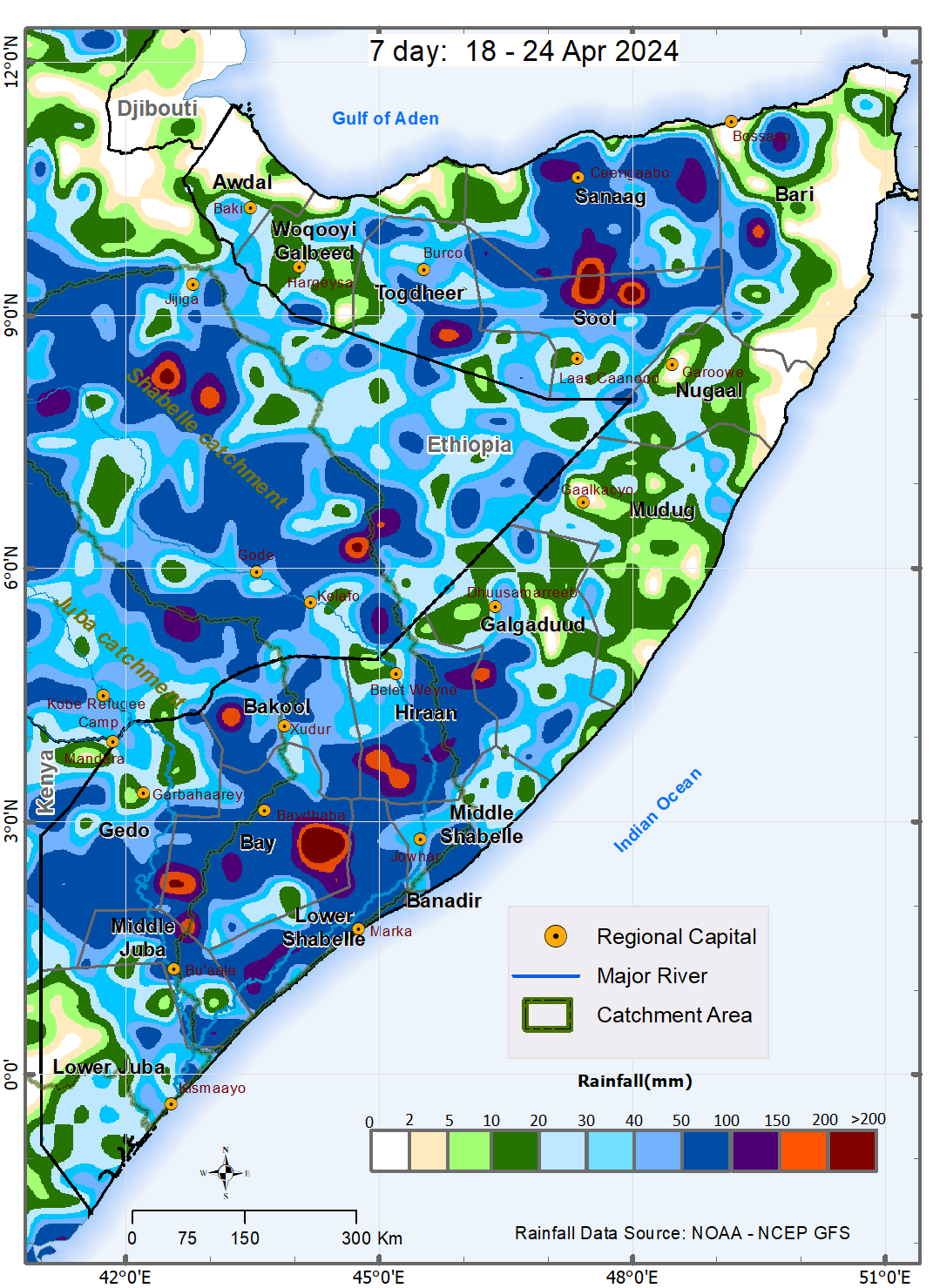
During the week between 18 and 24 April 2024, and based on NOAA-NCEP GFS, moderate to heavy rains are expected over several areas in the South West and Hirshabelle States with chances of very heavy rains over some areas in Bay and Sool-Sanaag regions. Light to moderate rain is expected over vast inland areas of Puntland with tendency of general dry conditions over the coastal areas of Bari and Nugaal regions. The chances of wetter conditions might be supported by the stagnation of Madden Julian Oscillation (MJO) index over the eastern parts of Indian Ocean. The small amplitude of the index however signifies weak cycles of the MJO. This therefore is associated with decreased skill and reliability of extended range forecasts. The tendency of general dry conditions over Bari is likely to be driven by the low-level easterly winds blowing parallel to the northeastern coastline which limits the incursions of precipitable water inland. The anticipated northward spread of the rains from South West into Hirshabelle and possibly Galgaduud is favored by the northward movement of the Inter Tropical Convergence Zone (ITCZ).
The temporal and spatial distribution of the forecast rainfall (Map 1) are as follows:
• Very heavy cumulative rainfall between 150 mm and 200 mm is likely over some areas in Dinsoor, Baydhaba and Buur Hababa districts in Bay region, southwestern parts of Bulo Burte district in Hiraan region, northwestern parts of Ceel Buur district in Galgaduud region, northern parts of Qardho district in Bari region, Xudun and Taleex district sin Sool region, southern parts of Ceerigaabo district in Sanaag region, and southern parts of Burco district in Togdheer region. The rains over isolated areas in the above parts of Bay, Sool and Sanaag regions may be very intense leading to more than 200 mm in cumulative terms and are likely to fall between 18 and 21 April 2024 with likelihood of flash flooding.
• Heavy cumulative rainfall between 100 mm and 150 mm is likely over the following areas: Dinsoor, Baydhaba and Buur Hababa districts in Bay region, Bulo Burte district in Hiraan region, northwestern parts of Ceel Buur district in Galgaduud region, northern parts of Qardho district in Bari region, Xudun and Taleex district sin Sool region, southern parts of Ceerigaabo district in Sanaag region, and southern parts of Burco district in Togdheer region. Such rains are alkso expected over southern parts of both Sablaale and Kurtunwaarey districts in Lower Shabelle region, eastern parts of Belet Weyne district in Hiraan region, northwen parts of Qandala district in Bari region, northern parts of Laasqoray district and northern parts of Ceerigaabo district in Sanaag region,
Moderate cumulative rainfall between 50 mm and 100 mm is likely over the rest of the areas in Bay and Sanaag regions, the rest of the areas in Xudun and Taleex district in Sool region, the rest of the areas in southern Burco district in Togdheer region, several areas in Lower Shabelle region, Ceel Waaq and Bardheere districts in Gedo region, Qansax Dheere district in Bay region, Balcad district in Middle Shabelle region, Qandala district and northern parts of Qardho district in Bari region, and over an area confined to the southern Hargeisa district in Woqooyi Galbeed.
Light cumulative rainfall of less than 50 mm is forecast over several areas in Lower Juba, Mudug and Nugaal, Awdal and Woqooyi Galbeed regions, the rest of the areas in Gedo and Bari regions, Jowhar, Cadale and Adan Yabaal districts in Middel Shabelle region. Such rains are likely over Borama districtareas in Gedo and Bari regions, Jowhar, Cadale and Adan Yabaal districts in Middel Shabelle region.
Dry conditions are likely to prevail over vast coastal areas in Nugaal and Bari region, Zeylac district and northern parts of both Lughaye and Baki districts in Awdal region, Berbera district in Woqooyi Galbeed region, and Ceel Afweyn district in Sanaag region.
Temperature Forecast:
Moderately high temperatures of between 35 ℃ and 40 ℃ are likely over Lower and Middle Juba regions, Galgaduud, Mudug and Bari regions, Dollow and Luuq districts in Gedo region, Sablaale and Wanla Weyn districts in Middle Shabelle region, southern parts fo both Dinsoor and Buur Hakaba districts in Bay region, western parts of both Belet Weyne and Bulo Burte districts in Hiraan region, Garowe district in Nugaal region, Sheikh district in Woqooyi Galbeed region, Zeylac and Lughaye districts and northern parts of Baki district in Awdal region.
Moderate temperatures of between 30 ℃ and 35 ℃ are likely the rest of the country except over Qandala in Bari region, Ceerigaabo in Sanaag region and northern parts of Odweyne in Togdheer region where temperatures less than 30 ℃ are anticipated.
Publication Type:
Rainfall Forecast
Publication Date:
Author:
Corporate Author:
Pages
 RSS feed [compliant with the Agris AP] |
  Agris AP XML


