Library Catalog
Latest Documents and Publications listed. Use search terms in the box below to find what you need

Somalia Dekadal Rainfall Bulletin - Dekad 30 2015
During the third dekad of October, (21st – 31st October 2015), wet conditions persisted in southern and central parts of the country with some parts of these regions experiencing flash floods. The north western parts remained dry throughout the month of October. Figure (1) shows the rainfall observational network and monthly rainfall distribution for selected stations across the country. The table below is a brief summary of the rainfall situation by region for this dekad. This update will be issued every 10-days throughout the Gu rainy season.
Publication Type:
Dekadal Rainfall Update
Publication Date:
Author:
Corporate Author:

Somalia Rainfall Forecast 26-10-2015
Heavy rains are expected to continue in the Ethiopian highlands, Hiraan, Middle Shabelle, Galgaduud and Mudug regions in the coming three days. Other areas that may record moderate rains include parts of Lower Shabelle, Bakool and Bay regions. The northern pats of the country and the Juba valley may record little or no rains during the same period.
Publication Type:
Rainfall Forecast
Publication Date:
Author:
Corporate Author:

Somalia Rainfall Forecast 19-10-2015
The forecast for the next three days points towards increased rains in most parts of Somalia and the Ethiopian highlands. However, light rains are forecasted for Lower Juba and the Bari regions during the same period.
Publication Type:
Rainfall Forecast
Publication Date:
Author:
Corporate Author:
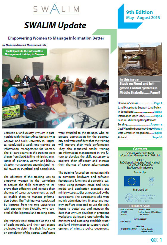
SWALIM Update Issue 9
We are pleased to share Issue 9 of our newsletter “SWALIM Update” for the period May 2015 - August 2015.
This issue of the newsletter provides updates on SWALIM water and land information management activities such as: What El Nino Means for Somalia, Empowering Women in Somalia with Information Management Skills, SWALIM Information Days in Somaliland and Puntland, Using Remote Sensing for Monitoring, Hydrogeology Study in Ceel Waaq District, Study on Flood and Irrigation Control Systems in Middle Shabelle and Data Centres in Mogadishu.
Publication Type:
Newsletter
Publication Date:
Author:
Corporate Author:
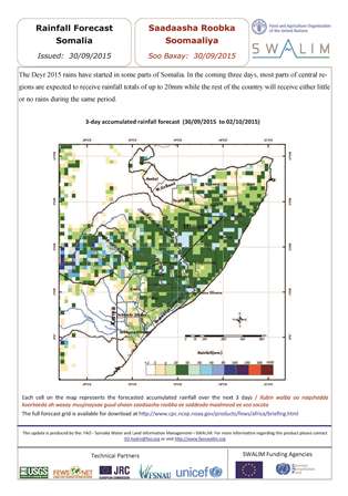
Somalia Rainfall Forecast 03-11-2015
Light rains spread across many southern and central parts of Somalia are expected in the next three days. The northern parts of the country are expected to receive moderate rains over the same period, with few pockets in Togdheer and Bari regions experiencing high rainfall of up to 100mm which can lead to flash floods. The upper catchment of the Shabelle River in Ethiopia will receive high rains as well, which translates to increase in river levels later in the week.
Publication Type:
Rainfall Forecast
Publication Date:
Author:
Corporate Author:
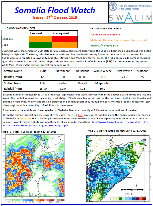
Flood Watch Bulletin 27-10-2015
The rainfall forecast for the coming week indicates heavy rains within the two basins both inside Somalia and Ethiopian highlands. Heavy rains are also expected in Banadir, Galgaduud, Mudug and parts of Nugaal, sool, Sanaag and Toghdheer regions with a possibility of flash floods in these areas.
River levels in the middle and lower reaches of Shabelle River are currently at full crest in some sections of the river.
Given the rainfall forecast and the current river levels, there is a high risk level of flooding along the middle and lower reaches of Shabelle. A Moderate risk of flooding is foreseen in the lower reaches of Juba River especially in locations where there exists open river breakages.
Publication Type:
Publication Date:
Author:
Corporate Author:

Somalia Rainfall Forecast 21-10-2015
The forecast for the next three days points towards increased rains in the Shabelle basin inside Somalia, the Ethiopian highlands as well as the central parts of the country . The North western parts may also record moderate rains while the lower parts of Juba and north eastern parts may receive light rains within the same period.
Publication Type:
Rainfall Forecast
Publication Date:
Author:
Corporate Author:

Somalia Rainfall Forecast 07-10-2015
The Deyr 2015 rains have started in some parts of Somalia. The upper parts of the Ethiopian highlands, Lower Juba region and north eastern parts of Somalia are expected to receive light to moderate rains within the next three days. Other parts of Somalia and the lower parts of the Ethiopian highland will receive little or no rains during the same period.
Publication Type:
Rainfall Forecast
Publication Date:
Author:
Corporate Author:

Somalia Rainfall Forecast 28-10-2015
Heavy rains are expected to continue in the Ethiopian highlands and most parts of Somalia except Awdal, Bari, Nugaal and Mudug regions. Toghdheer, Bay and Lower Shabelle regions are expected to receive the highest amounts which may lead to flash floods and river floods in respective areas.
Publication Type:
Rainfall Forecast
Publication Date:
Author:
Corporate Author:
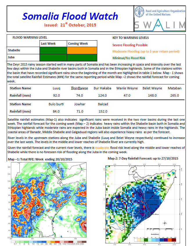
Flood Watch Bulletin 21-10-2015
The Deyr 2015 rainy season started well in many parts of Somalia and has been increasing in space and intensity over the past few days within the Juba and Shabelle river basins both in Somalia and in the Ethiopian highlands.
River levels in the upstream stations along the Juba and Shabelle (Luuq and Belet Weyne respectively) continued to increase over the last week. The levels in the middle and lower reaches of Shabelle River are currently high.
Given the current river levels and the current rainfall forecast (which indicates heavy rains within the Shabelle basin both in Somalia and the Ethiopian highlands; moderate rains expected in the Juba basin inside Somalia; heavy rains in the highlands and the coastal areas of Banadir, Middle Shabelle and Galgaduud), there is a moderate flood risk level along the middle and lower reaches of Shabelle while there is no foreseen risk of flooding along the Juba in the coming week.
Publication Type:
Flood watch bulletin
Publication Date:
Author:
Corporate Author:
Pages
 RSS feed [compliant with the Agris AP] |
  Agris AP XML