English
Somali
Home
About Us
The 25 Best Air Force basketball 1 Colourways of All Time , IetpShops , Nike Swoosh logo embroidered fleece shorts
Nike WMNS Air Jordan 1 High Acclimate Brown Basalt 25.5cm , Nike Air Jordan 1 Mid "Grey Camo" , Fenua-environnementShops Marketplace
Nike air jordan max 13 hologram Bred Black Red 2019 Release Date , air jordan max 1 rebel chicago white varsity red black , IetpShops
Super Max Perfect Air Jordan 5 Women
Cheap Rcj Jordan Outlet - choice jordan True Flight Bordeaux - Michael Beasley right defending in the Flint Grey Air choice jordan 7
air jordan 36
Air Jordan 1 Mid GS DJ0338 100 Release Date 4
air jordan releases 2022
nike dunk low panda black white dd1391 100 release date
nike air max plus white black metallic pewter ct1094 102 release date info
Who We are
Liaison Offices
Project Phases
List of Phases
SWALIM Phase VI
Project Activities
Water Resources
Climate
Weather Monitoring
Weather Updates
Surface Water
Ground Water
Irrigation
Flood Monitoring
Drought Monitoring
Water Publications
Land Resources
Soils
Land Cover
Land Use
Land Suitability
Land Degradation
Land Publications
Remote Sensing
Information Management
Information Services
Online Systems
Offline Systems
Alerts and Bulletins
Client Services
Publications
Newsletters
Library
Capacity Development
Ministry Capacity Development Scheme
Ministry data centres
Training Programme
Training courses
Academic Institution Partnership
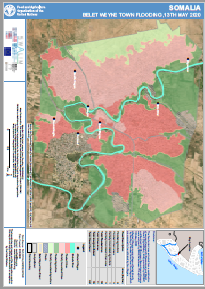
Belet Weyne Flood Update - Issued 15 May 2020
Language
English
Thumbnail Image:
Feature Article:
Yes
Log in
to post comments