Useful Links
Use of SWALIM's live map for water sources information access in drought response
 Somalia has been experiencing one of the most severe drought conditions in the recent past, following consecutive seasons of failed rainfall across the country. Many parts of the country are experiencing acute water shortage and dramatic deterioration of food security. As a result, the humanitarian agencies have scaled up interventions since the beginning of the year to respond to the drought and prevent famine.
FAO SWALIM continues to provide information on weather, river levels and groundwater, which informs planning and prioritization of water related interventions. Key among the ongoing drought interventions by different clusters is water trucking for domestic use and livestock watering. Majority of the water sources in the country dried up due to the prolonged drought, including the only perennial rivers in the country – Juba and Shabelle. Groundwater from key strategic water sources, mainly boreholes, became the only source of water for both rural and urban use across the country. There was need therefore, to keep monitoring the status of these strategic boreholes, and provide information to the humanitarian agencies to plan and carry out water trucking and other interventions.
Keeping up to date information and providing an updated information on the strategic boreholes requires a consolidated effort of different stakeholders. This would ensure country wide coverage, as government water authorities and other partners complement each other with information based on their area of operation.
The Somalia WASH Cluster has been very instrumental in coordinating the field updates from the different partners, while SWALIM is tasked with consolidating and mapping the field reports. In Somaliland and Puntland the Government Water Authorities namely Ministry of Water Resources and Puntland Water Authority for Water, Energy and Natural Resources respectively have been actively involved in providing regular updates within their regions.
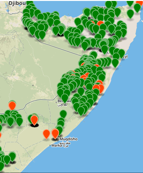
SWALIM makes use of the existing tools to disseminate the strategic boreholes status information. This includes the online Water Sources Live Map, accessible through the link;
http://systems.faoso.net/frrims/water_sources/index . The live map provides partners with an interactive interface where they can get an overview of the spatial distribution of the boreholes in each region, as well as detailed information about specific boreholes including the exact location, depth, functional status, water quality (salinity), yield, water price, etc. Agencies carrying out water related interventions, mainly trucking, are making use of this information to identify the available boreholes for water trucking and the distances involved, as this has implications on the cost.
Some parts of the country have however not been covered during the latest status updates. SWALIM is working with agencies with presence in those areas to provide this critical information, for the benefit of the Somali community in dire need of water access during this time of drought. SWALIM will continue to regularly update the data for the areas already mapped. latest Running Sneakers | lebron 14 cocoa beach for sale size 2 , Air Jordan Release Dates 2021 + 2022 Updated , Gov