Library Catalog
Latest Documents and Publications listed. Use search terms in the box below to find what you need
Somalia Rainfall Forecast – Issued 26 July 2022
The last one week has seen a reduction in recorded rainfall amounts compared to previous weeks since the onset of the Karan rains. Most parts of the country remained dry for that period.
The cumulative rainfall forecast for the next seven days indicates moderate rainfall in Awdal and the western side of Woqooyi Galbeed; while in eastern Woqooyi Galbeed and parts of Togdheer Regions light rains are foreseen.
Light rains are also foreseen along the coastal strip in the southern regions. The rest of the country will remain dry for the coming week. Moderate to high rains are expected in the Ethiopian highlands, where Juba and Shabelle Rivers originate.
Despite the rains received in parts of the country, drought conditions persist due across Somalia. The rains need to be well distributed and sustained over a long period, to alleviate the current drought situation.
Publication Type:
Rainfall Forecast
Publication Date:
Author:
Corporate Author:
Somalia Rainfall Forecast – Issued 05 July 2022
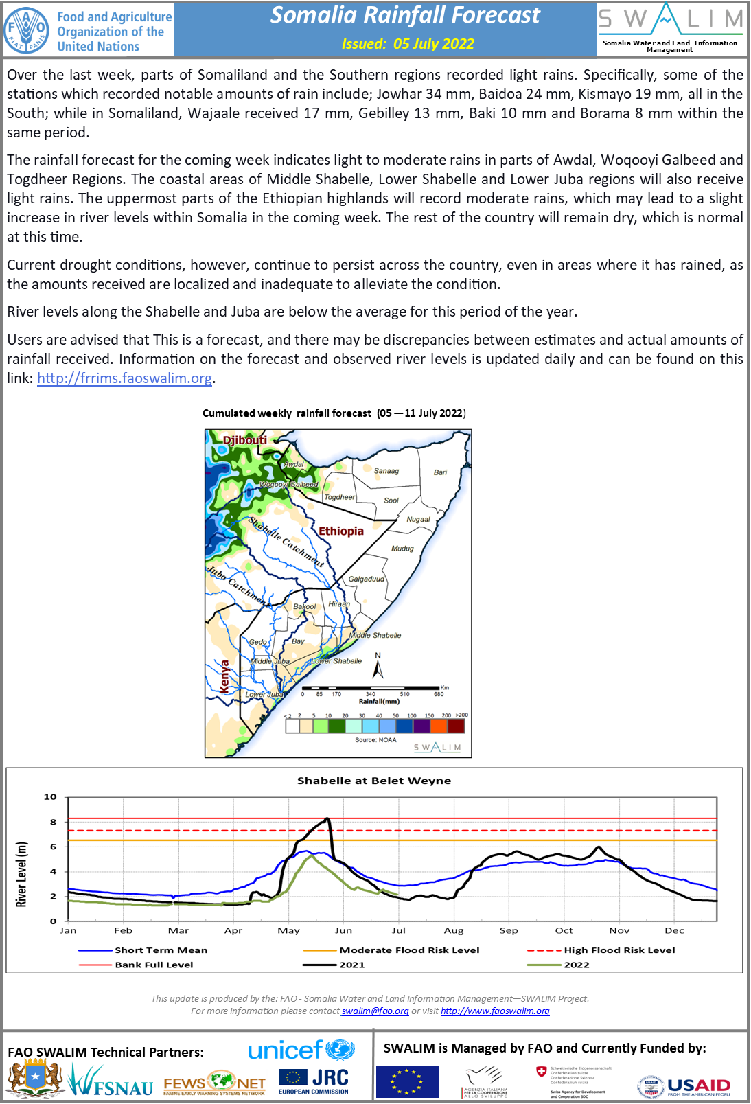
Over the last week, parts of Somaliland and the Southern regions recorded light rains. Specifically, some of the stations which recorded notable amounts of rain include; Jowhar 34 mm, Baidoa 24 mm, Kismayo 19 mm, all in the South; while in Somaliland, Wajaale received 17 mm, Gebilley 13 mm, Baki 10 mm and Borama 8 mm within the same period.
The rainfall forecast for the coming week indicates light to moderate rains in parts of Awdal, Woqooyi Galbeed and Togdheer Regions. The coastal areas of Middle Shabelle, Lower Shabelle and Lower Juba regions will also receive light rains. The uppermost parts of the Ethiopian highlands will record moderate rains, which may lead to a slight increase in river levels within Somalia in the coming week. The rest of the country will remain dry, which is normal at this time.
Current drought conditions, however, continue to persist across the country, even in areas where it has rained, as the amounts received are localized and inadequate to alleviate the condition.
River levels along the Shabelle and Juba are below the average for this period of the year.
Publication Type:
Rainfall Forecast
Publication Date:
Author:
Corporate Author:
Somalia Rainfall Forecast – Issued 13 July 2022
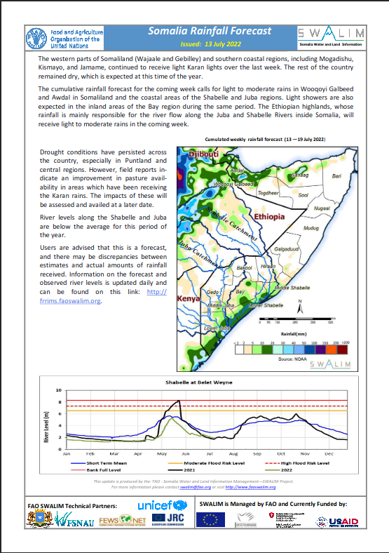
The western parts of Somaliland (Wajaale and Gebilley) and southern coastal regions, including Mogadishu, Kismayo, and Jamame, continued to receive light Karan lights over the last week. The rest of the country remained dry, which is expected at this time of the year.
The cumulative rainfall forecast for the coming week calls for light to moderate rains in Wooqoyi Galbeed and Awdal in Somaliland and the coastal areas of the Shabelle and Juba regions. Light showers are also expected in the inland areas of the Bay region during the same period. The Ethiopian highlands, whose rainfall is mainly responsible for the river flow along the Juba and Shabelle Rivers inside Somalia, will
receive light to moderate rains in the coming week.
Publication Type:
Rainfall Forecast
Publication Date:
Author:
Corporate Author:
Somalia Drought Update and GU 2022 Rainfall Performance – Issued 14 June 2022
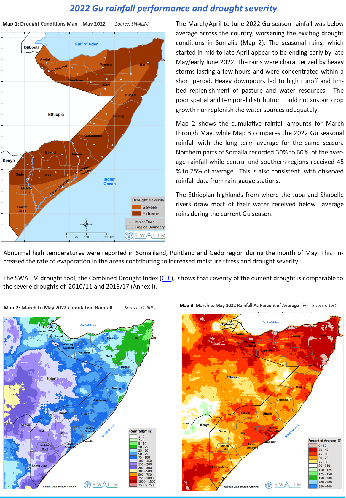
The 2022 Gu rainy season in Somalia came to an early end in May, with depressed rainfall amounts recorded and forecasts indicating little to no rainfall through mid-June . The overall seasonal rainfall performance was poor. The northern areas recorded 30% to 60% of the average rainfall while the central and southern areas received 45 % to 75%. This marks a fourth consecutive failed rainy season since late 2020.
Gu season rainfall has moderated drought conditions in most parts of the country as it replenished pasture and water resources. However, this improvement is expected to be short-lived as and drought conditions are expected to worsen throughout the prolonged dry Hagaa (July-September) dry season.
Current climate forecasts indicate a 62 per cent chance of La Niña during the June to August 2022 period (IRI). La Niña is generally associated with drought conditions in the Horn of Africa region, including Somalia. The next seasonal rains are not expected until mid-October and available long-range forecasts indicate that a record fifth below-average rainy season is likely across Somalia during the forthcoming October and December 2022 Deyr season. This could set the conditions for a worsening multi-season drought well into 2023.
More than 80 per cent of Somalia is currently facing severe to extreme drought conditions. The drought severity levels are comparable to that of 2010/11 and 2016/17 as seen in Annex I.
Water resources are expected to decline drastically during the forthcoming dry season as water demand and use increases. In Garowe, there was abnormal drop in ground water level of seven meters between October 2021 and May 2022 (Annex II).
The Juba and Shabelle River levels are currently 30 percent below the short-term average, with limited water available to support irrigation of crops and other uses. The river levels are expected to decrease further in the coming weeks and months.
The vegetation conditions that had improved in some areas as a results of the Gu season rains are expected to be depleted soon due to the low level of biomass recovery and likely influx of livestock into these areas. The Prospects for Gu season cereal production remain bleak, with crop failure expected in many areas . Due to the poor rains, some communities did not plant during this season. Dry and hot conditions will continue across most parts of the country during this dry Haggai (June/July-September ) season except for parts of Somaliland that will receive moderate Karan rains.
With no significant rains foreseen until the next rainy season in October, and the La Nina predictions, the current drought situation will deteriorate further in Somalia. The negative trends are not expected to reverse until the arrival of Deyr (Oct-Dec) 2022 rains. However, the preliminary forecast for the Deyr 2022 season is also below average—FEWSNET
Publication Type:
Drought watch
Publication Date:
Author:
Corporate Author:
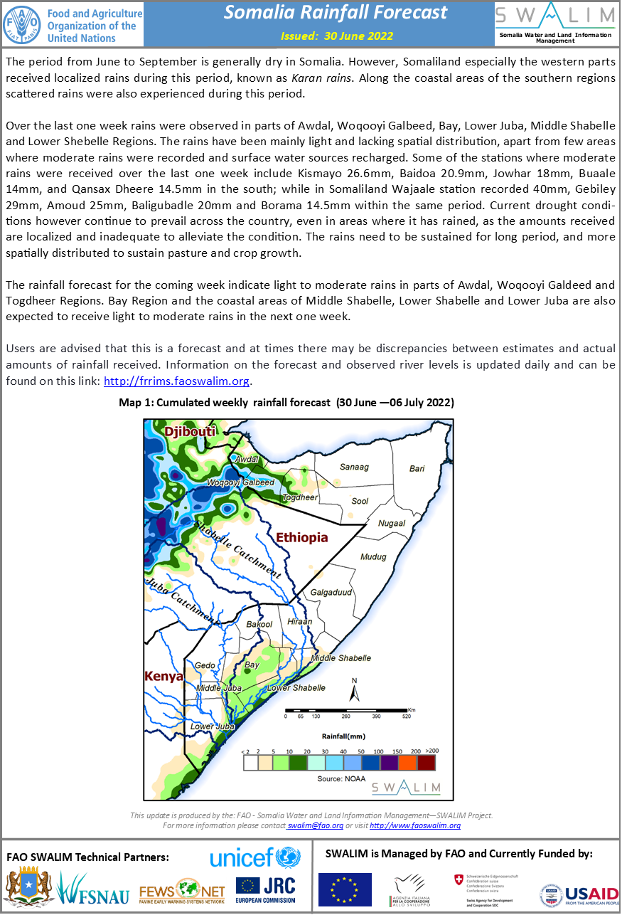
Somalia Rainfall Forecast – Issued 30 June 2022
The period from June to September is generally dry in Somalia. However, Somaliland especially the western parts received localized rains during this period, known as Karan rains. Along the coastal areas of the southern regions scattered rains were also experienced during this period.
Over the last one week rains were observed in parts of Awdal, Woqooyi Galbeed, Bay, Lower Juba, Middle Shabelle and Lower Shebelle Regions. The rains have been mainly light and lacking spatial distribution, apart from few areas where moderate rains were recorded and surface water sources recharged. Some of the stations where moderate rains were received over the last one week include Kismayo 26.6mm, Baidoa 20.9mm, Jowhar 18mm, Buaale 14mm, and Qansax Dheere 14.5mm in the south; while in Somaliland Wajaale station recorded 40mm, Gebiley 29mm, Amoud 25mm, Baligubadle 20mm and Borama 14.5mm within the same period. Current drought conditions however continue to prevail across the country, even in areas where it has rained, as the amounts received are localized and inadequate to alleviate the condition. The rains need to be sustained for long period, and more spatially distributed to sustain pasture and crop growth.
The rainfall forecast for the coming week indicate light to moderate rains in parts of Awdal, Woqooyi Galdeed and Togdheer Regions. Bay Region and the coastal areas of Middle Shabelle, Lower Shabelle and Lower Juba are also expected to receive light to moderate rains in the next one week.
Publication Type:
Rainfall Forecast
Publication Date:
Author:
Corporate Author:
Somalia Rainfall Forecast – Issued 25 May 2022
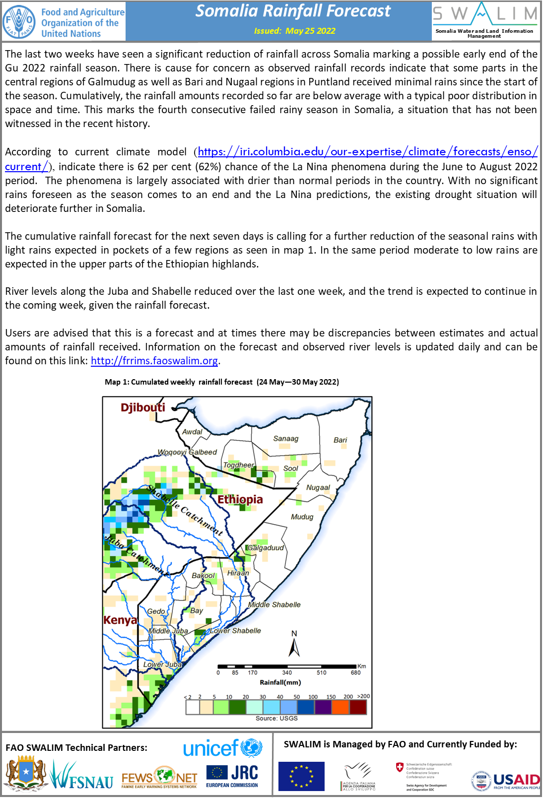
The last two weeks have seen a significant reduction of rainfall across Somalia marking a possible early end of the Gu 2022 rainfall season. There is cause for concern as observed rainfall records indicate that some parts in the central regions of Galmudug as well as Bari and Nugaal regions in Puntland received minimal rains since the start of the season. Cumulatively, the rainfall amounts recorded so far are below average with a typical poor distribution in space and time. This marks the fourth consecutive failed rainy season in Somalia, a situation that has not been witnessed in the recent history.
According to current climate model (https://iri.columbia.edu/our-expertise/climate/forecasts/enso/current/), indicate there is 62 per cent (62%) chance of the La Nina phenomena during the June to August 2022 period. The phenomena is largely associated with drier than normal periods in the country. With no significant rains foreseen as the season comes to an end and the La Nina predictions, the existing drought situation will deteriorate further in Somalia.
The cumulative rainfall forecast for the next seven days is calling for a further reduction of the seasonal rains with light rains expected in pockets of a few regions. In the same period moderate to low rains are expected in the upper parts of the Ethiopian highlands.
River levels along the Juba and Shabelle reduced over the last one week, and the trend is expected to continue in the coming week, given the rainfall forecast.
Publication Type:
Rainfall Forecast
Publication Date:
Author:
Corporate Author:
Somalia Rainfall Forecast – Issued 04 May 2022
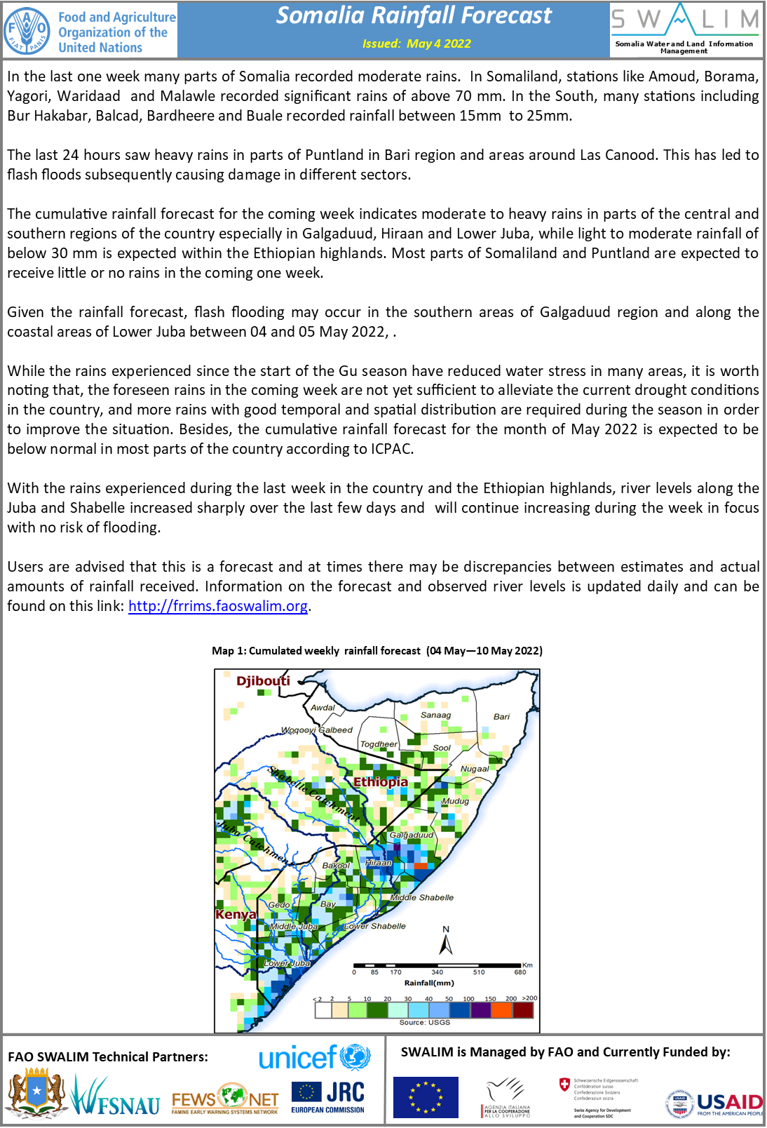
In the last one week many parts of Somalia recorded moderate rains. In Somaliland, stations like Amoud, Borama, Yagori, Waridaad and Malawle recorded significant rains of above 70 mm. In the South, many stations including Bur Hakabar, Balcad, Bardheere and Buale recorded rainfall between 15mm to 25mm.
The last 24 hours saw heavy rains in parts of Puntland in Bari region and areas around Las Canood. This has led to flash floods subsequently causing damage in different sectors.
The cumulative rainfall forecast for the coming week indicates moderate to heavy rains in parts of the central and southern regions of the country especially in Galgaduud, Hiraan and Lower Juba, while light to moderate rainfall of below 30 mm is expected within the Ethiopian highlands. Most parts of Somaliland and Puntland are expected to receive little or no rains in the coming one week.
Given the rainfall forecast, flash flooding may occur in the southern areas of Galgaduud region and along the coastal areas of Lower Juba between 04 and 05 May 2022, .
While the rains experienced since the start of the Gu season have reduced water stress in many areas, it is worth noting that, the foreseen rains in the coming week are not yet sufficient to alleviate the current drought conditions in the country, and more rains with good temporal and spatial distribution are required during the season in order to improve the situation. Besides, the cumulative rainfall forecast for the month of May 2022 is expected to be below normal in most parts of the country according to ICPAC.
With the rains experienced during the last week in the country and the Ethiopian highlands, river levels along the Juba and Shabelle increased sharply over the last few days and will continue increasing during the week in focus with no risk of flooding.
Publication Type:
Rainfall Forecast
Publication Date:
Author:
Corporate Author:
Somalia Rainfall Forecast – Issued 19 May 2022
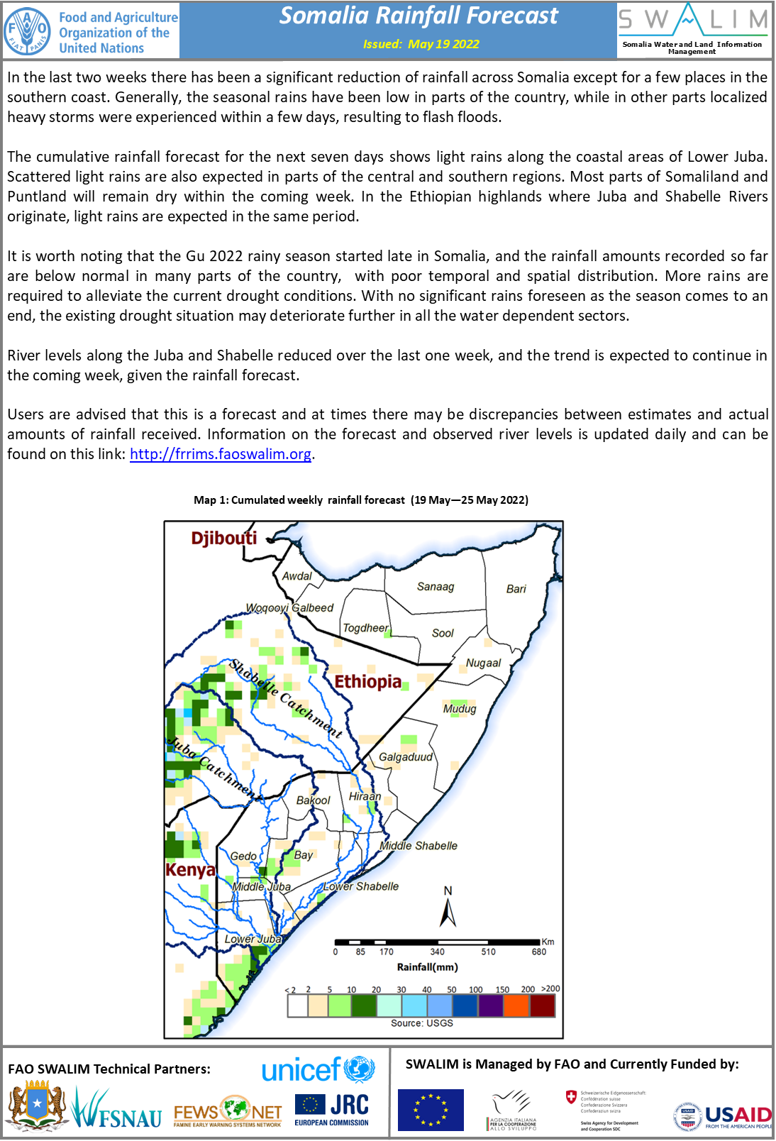
In the last two weeks there has been a significant reduction of rainfall across Somalia except for a few places along the southern coast. Generally, the seasonal rains have been low in parts of the country, while in other parts localized heavy storms were experienced within a few days, resulting to flash floods such as Las Anod in Sool Region, Ceerigabo in Sanaag, and Jedaal/Ufeyn in Bari Region.
The cumulative rainfall forecast for the next seven days shows light rains along the coastal areas of Lower Juba. Scattered light rains are also expected in parts of the central and southern regions. Most parts of Somaliland and Puntland will remain dry within the coming week. In the Ethiopian highland where Juba and Shabelle Rivers originate light rains are expected within the same period.
It is worth noting that the Gu 2022 rainy season started late in Somalia, and the rainfall amounts recorded so far are below normal in many parts of the country, with poor temporal and spatial distribution. More rains are required to alleviate the current drought conditions. With no significant rains foreseen as the season comes to an end, the existing drought situation may deteriorate further in all the water dependent sectors.
River levels along the Juba and Shabelle reduced over the last one week, and the trend is expected to continue in the coming week, given the rainfall forecast.
Publication Type:
Rainfall Forecast
Publication Date:
Author:
Corporate Author:
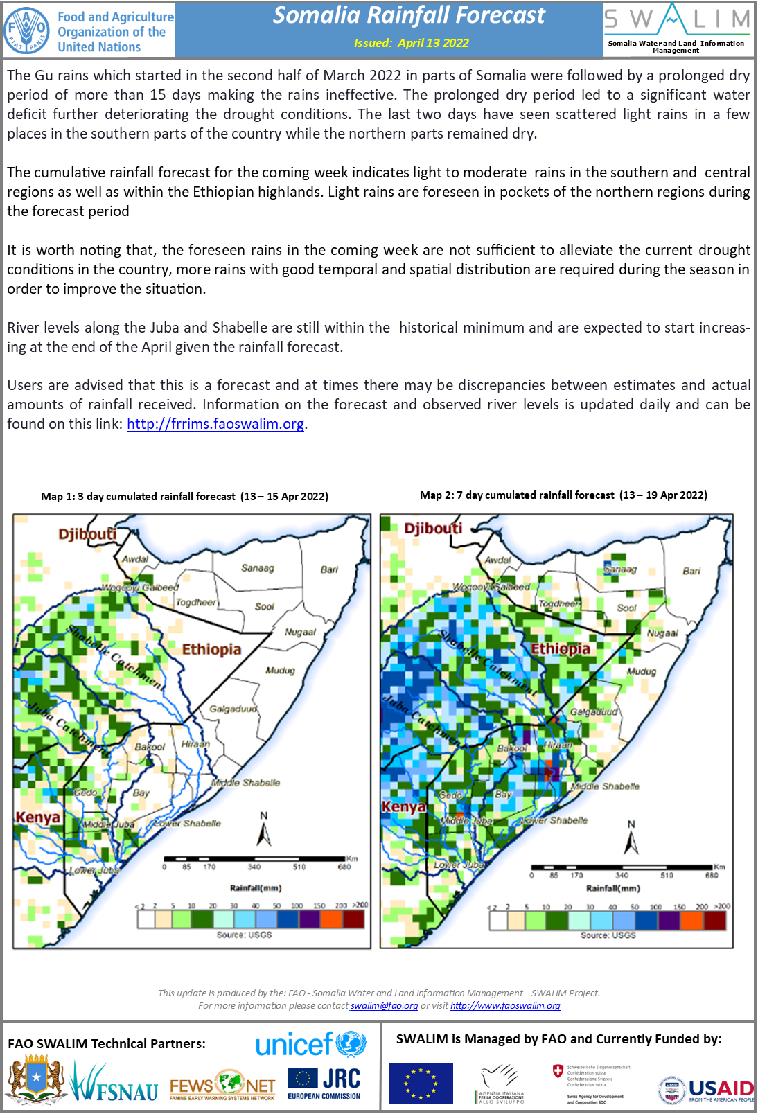
Somalia Rainfall Forecast – Issued 13 April 2022
The Gu rains which started in the second half of March 2022 in parts of Somalia were followed by a prolonged dry period of more than 15 days making the rains ineffective. The prolonged dry period led to a significant water deficit further deteriorating the drought conditions. The last two days have seen scattered light rains in a few places in the southern parts of the country while the northern parts remained dry.
The cumulative rainfall forecast for the coming week indicates light to moderate rains in the southern and central regions as well as within the Ethiopian highlands. Light rains are foreseen in pockets of the northern regions during the forecast period
It is worth noting that, the foreseen rains in the coming week are not sufficient to alleviate the current drought conditions in the country, more rains with good temporal and spatial distribution are required during the season in order to improve the situation.
River levels along the Juba and Shabelle are still within the historical minimum and are expected to start increasing at the end of the April given the rainfall forecast.
Publication Type:
Rainfall Forecast
Publication Date:
Author:
Corporate Author:
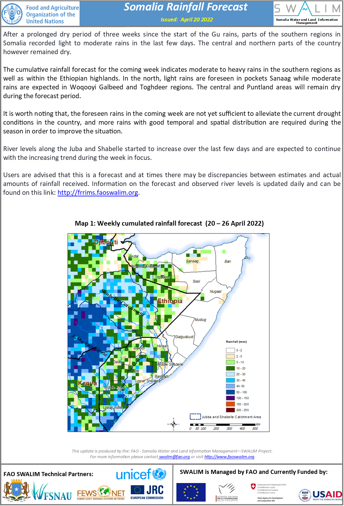
Somalia Rainfall Forecast – Issued 20 April 2022
After a prolonged dry period of three weeks since the start of the Gu rains, parts of the southern regions in Somalia recorded light to moderate rains in the last few days. The central and northern parts of the country however remained dry.
The cumulative rainfall forecast for the coming week indicates moderate to heavy rains in the southern regions as well as within the Ethiopian highlands. In the north, light rains are foreseen in pockets Sanaag while moderate rains are expected in Woqooyi Galbeed and Toghdeer regions. The central and Puntland areas will remain dry during the forecast period.
It is worth noting that, the foreseen rains in the coming week are not yet sufficient to alleviate the current drought conditions in the country, and more rains with good temporal and spatial distribution are required during the season in order to improve the situation.
River levels along the Juba and Shabelle started to increase over the last few days and are expected to continue with the increasing trend during the week in focus.
Publication Type:
Publication Date:
Author:
Corporate Author:
Pages
 RSS feed [compliant with the Agris AP] |
  Agris AP XML