Library Catalog
Latest Documents and Publications listed. Use search terms in the box below to find what you need
Somalia Drought Update – April 2021.pdf
The Gu rains continued to spread in time and space over the last few days with some places recording moderate rains. Many parts of Bay, Bakool and Puntland recorded good rains on 19 to 21 April 2021. The Gu rains are yet to start in some areas.
Despite the Gu 2021 having started, more than 80 percent of the country is currently experiencing moderate to severe drought conditions This is due to below average 2020 Oct-Dec Deyr rains, followed by a harsh and warmer than normal Jan-Mar Jilaal season, and a delayed start of the current Gu (Mar/Apr-Jun) season with a poor distribution.
Worst affected areas include larger parts of Somaliland and Puntland, central regions and Gedo region Currently, water levels along Shabelle river are slightly below average while water levels in the Juba river are within the normal range. The levels in both rivers are expected to increase following the start of Gu rains in the Ethiopian highlands and within Somalia.
Preliminary rainfall forecast for the coming months of May and June indicates depressed amounts of rainfall and this may worsen the ongoing drought in many parts of the country. If Gu season rainfall continues to perform poorly, this could lead to a worsening of the current humanitarian situation in Somalia through late 2021, especially in rural areas.
Publication Type:
Drought watch
Publication Date:
Author:
Corporate Author:
Status of River Breakages Along Juba and Shabelle Rivers - Issued March 2021
In the recent years, floods have prevailed in Somalia hampering both social and economic development. Rainfall intensity in the Ethiopian highlands triggered riverine flooding along the Juba and Shabelle rivers in the last three consecutive years. With climate models projecting an increase of rainfall intensities in the region in the coming yeras, flood events will therefore continue to take place if nothing is done. The presence of open and weak river banks contributes significantly to flooding along these two major rivers. It is therefore of paramount importance to try and reduce or rather prevent these losses due to flood events.
With the objective of identifying locations and dimensions of the open and weak points along the Juba and Shabelle Rivers, SWALIM has carried out an assessment using very high resolution (VHR) satellite images. The activity aimed to ascertain the existence of such points and share with intervening agencies and other partners to inform decisions for closure of the points which would see a reduction of flood impacts along the river.
Along the Juba River, 46 open points, 8 overflows and another 65 potential overflows were identified. The Juba River assessment also identified over 100 potential breakage points. Further, the team have identified 57 open points, 225 overflows and 74 potential overflows along the Shabelle River. These points need immediate closure or reinforcement before the Gu rainy season which is expected to start in Mid-April 2021.
It is worth noting that due to limited availability of VHR images, there has been a delay in completing the assessment of Shabelle River breakages. FAO SWALIM is in the process of procuring images to cover the assessment gap and partners will be notified once the finalized product is ready.
SWALIM is pleased to share with you the status of open river points maps along the Juba and Shabelle which can be downloaded from the download links.
Publication Type:
Map
Publication Date:
Author:
Corporate Author:
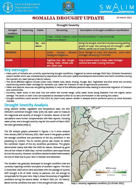
Somalia Drought Update – Issued March 2021
Many parts of Somalia are currently experiencing drought conditions, triggered by below average 2020 Deyr (October-December) season rainfall which was characterized by depressed rains with poor spatial and temporal distributions and harsh conditions during the typically dry Jiaall (January-March) season. The worst affected regions include Lower Juba, Middle Juba, Gedo, Mudug, Nuugal, Bari, Toghdheer and Sool which are currently experiencing severe water shortage for domestic use, water for livestock as well as agricultural production. Water and pasture resources are getting depleted in most of the affected pastoral areas leading to abnormal migration of livestock and communities. Currently, water levels in the Juba river are within the normal range, while water levels along Shabelle river are slightly below average. The levels in both rivers are expected to decrease further as no rains are foreseen in the coming two weeks. Drought conditions could worsen if the 2021 Gu (April-June) season rainfall is delayed and/or performs poorly as some forecasts indicate.
Publication Type:
Drought watch
Publication Date:
Author:
Corporate Author:
Somalia Gu 2021 Rainfall Forecast and Weather Update
Equal chances of average, enhanced and depressed rains expected during the Gu 2021 season.
According to the March to May 2021 seasonal forecast issued by IGAD Climate Prediction and Application Center (ICPAC) during the Greater Horn of Africa Climate Outlook Forum (GHACOF57), there are equal chances of receiving either above average, average or below average rainfall amounts in most parts of Somalia.
The three-month outlook favours a similar situation for the eastern Ethiopian highlands which are responsible for most of the flow in the Juba and Shabelle rivers in Somalia.
A few pockets in Puntland within Bari and Sanaag regions will receive enhanced rains during the season.
Warmer than usual season is expected in the northern areas while relatively cooler conditions are likely to occur in the southern parts of Somalia.
In contrast, forecast from FEWS NET’s science partners (NOAA/CPC, NASA/GFSC and CHC) indicates: (1) cumulative rainfall during the March-June 2021 long rains/Gu season in Somalia is most likely to be below-average in Somalia, (2) Gu season rainfall onset is likely to be poor or delayed, and (3) there is an increased likelihood that the rainfall amounts will be widely below average in May, which may signal an earlier-than-normal end of the rainfall season.
Given the above seasonal rainfall forecast, all sectors should be prepared for both best and worst case scenarios. However, a pessimistic forecast should be considered for humanitarian response planning during Gu 2021. SWALIM and partners will closely monitor the situation and provide shorter timescale forecasts throughout the season.
Sunny and dry weather conditions characterized by higher than average daytime temperatures prevailed over most parts of the country since December 2020. The unusually dry period is as a result of the poor Deyr 2020 rainfall season in many parts of the country.
The areas in northern and central Somalia worst affected by poor rainfall during the 2020 Deyr (October-December) season are currently experiencing mild to moderate drought conditions, leading to water shortages and high water prices. The local authorities in these areas have initiated water tracking activities with Sanaag, Bari, Nuugal and Mudug areas being worst affected by the water shortage.
The Juba and Shabelle river levels are very low at this time of the year. Parts of the middle and lower reaches of the Shabelle River are reportedly dry leaving insufficient flow to support irrigation along the river.
Whether this drought condition deteriorates to a full-fledged drought or improves will depend on the timeliness, amount and distribution of the forthcoming Gu season rainfall.
A more detailed downscaled outlook will be released in the coming days by national inter-ministerial meteorological working group (IMMWG) of Somalia. The downscaled outlook is expected to cover sectorial impacts and advisories for the coming season.
Publication Type:
Rainfall Outlook
Publication Date:
Author:
Corporate Author:
Status and Impacts of Open River Points along the Shabelle River in Jowhar, Balcad and Afgooye Districts
A recent flood analysis by SWALIM indicates that there has been an increase in flood frequency and intensity in the last 10 years along the riverine areas of Juba and Shabelle Rivers in Somalia. Recognizing the recurrent flooding along the Shabelle River in the last few years, SWALIM undertook a field survey in Jowhar, Balcad and Afgooye districts. The objective of the survey was to map existing open and weak river embankments in the three districts.
We are pleased to share with you the status and impacts of open river points along the Shabelle River in Jowhar, Balcad and Afgooye Districts bulletin and related annexes.
Publication Type:
Flood Alert
Publication Date:
Author:
Corporate Author:
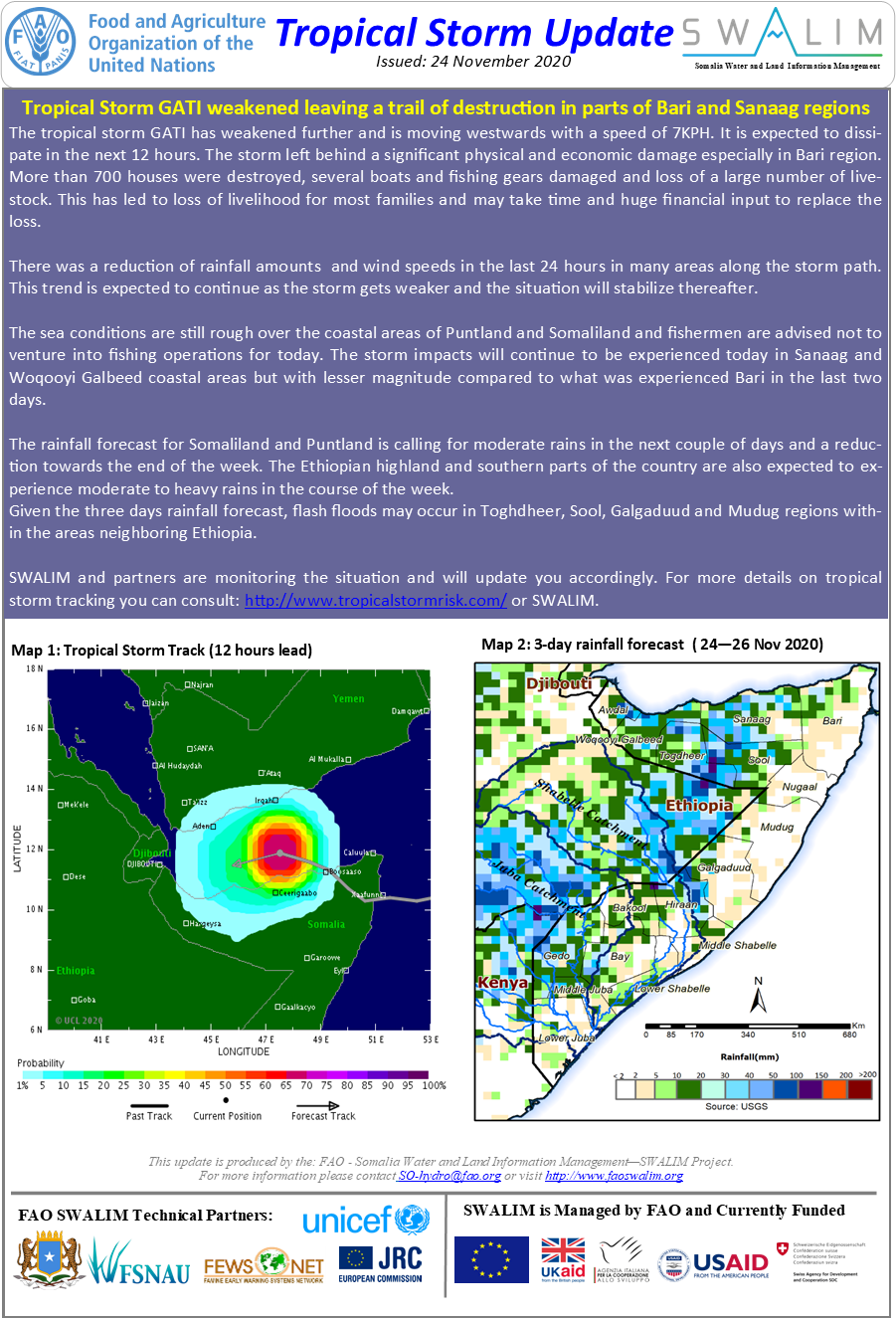
Tropical Storm Update - Issued: 24 November 2020
Tropical Storm GATI weakened leaving a trail of destruction in parts of Bari and Sanaag regions
The tropical storm GATI has weakened further and is moving westwards with a speed of 7KPH. It is expected to dissipate in the next 12 hours. The storm left behind a significant physical and economic damage especially in Bari region. More than 700 houses were destroyed, several boats and fishing gears damaged and loss of a large number of livestock. This has led to loss of livelihood for most families and may take time and huge financial input to replace the loss.
There was a reduction of rainfall amounts and wind speeds in the last 24 hours in many areas along the storm path. This trend is expected to continue as the storm gets weaker and the situation will stabilize thereafter.
The sea conditions are still rough over the coastal areas of Puntland and Somaliland and fishermen are advised not to venture into fishing operations for today. The storm impacts will continue to be experienced today in Sanaag and Woqooyi Galbeed coastal areas but with lesser magnitude compared to what was experienced Bari in the last two days.
The rainfall forecast for Somaliland and Puntland is calling for moderate rains in the next couple of days and a reduction towards the end of the week. The Ethiopian highland and southern parts of the country are also expected to experience moderate to heavy rains in the course of the week.
Given the three days rainfall forecast, flash floods may occur in Toghdheer, Sool, Galgaduud and Mudug regions within the areas neighboring Ethiopia.
Publication Type:
Storm Alert
Publication Date:
Author:
Corporate Author:
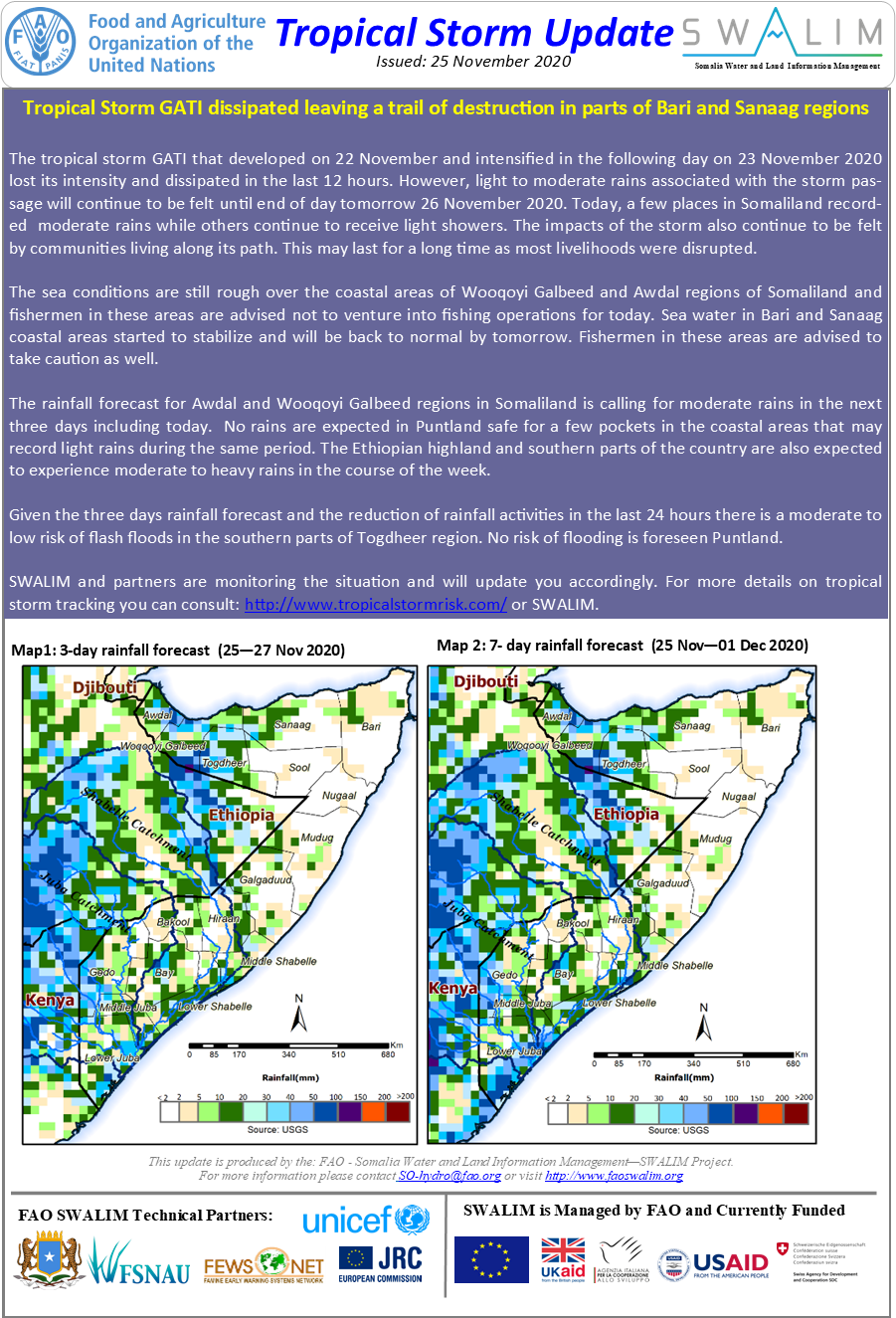
Tropical Storm Update - Issued: 25 November 2020
Tropical Storm GATI dissipated leaving a trail of destruction in parts of Bari and Sanaag regions
The tropical storm GATI that developed on 22 November and intensified in the following day on 23 November 2020 lost its intensity and dissipated in the last 12 hours. However, light to moderate rains associated with the storm passage will continue to be felt until end of day tomorrow 26 November 2020. Today, a few places in Somaliland recorded moderate rains while others continue to receive light showers. The impacts of the storm also continue to be felt by communities living along its path. This may last for a long time as most livelihoods were disrupted.
The sea conditions are still rough over the coastal areas of Wooqoyi Galbeed and Awdal regions of Somaliland and fishermen in these areas are advised not to venture into fishing operations for today. Sea water in Bari and Sanaag coastal areas started to stabilize and will be back to normal by tomorrow. Fishermen in these areas are advised to take caution as well.
The rainfall forecast for Awdal and Wooqoyi Galbeed regions in Somaliland is calling for moderate rains in the next three days including today. No rains are expected in Puntland safe for a few pockets in the coastal areas that may record light rains during the same period. The Ethiopian highland and southern parts of the country are also expected to experience moderate to heavy rains in the course of the week.
Given the three days rainfall forecast and the reduction of rainfall activities in the last 24 hours there is a moderate to low risk of flash floods in the southern parts of Togdheer region. No risk of flooding is foreseen Puntland.
Publication Type:
Storm Alert
Publication Date:
Author:
Corporate Author:
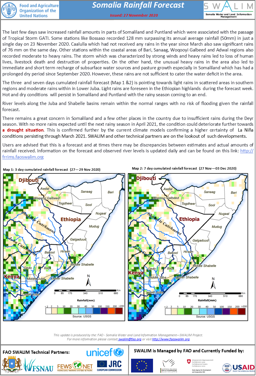
Somalia Rainfall Forecast - Issued: 27 November 2020
The last few days saw increased rainfall amounts in parts of Somaliland and Puntland which were associated with the passage of Tropical Storm GATI. Some stations like Bossaso recorded 128 mm surpassing its annual average rainfall (50mm) in just a single day on 23 November 2020. Caalulla which had not received any rains in the year since March also saw significant rains of 76 mm on the same day. Other stations within the coastal areas of Bari, Sanaag, Woqooyi Galbeed and Adwal regions also recorded moderate to heavy rains. The storm which was characterized by strong winds and heavy rains led to loss of human lives, livestock death and destruction of properties. On the other hand, the unusual heavy rains in the area also led to immediate and short term recharge of subsurface water sources and pasture growth especially in Somaliland which has had a prolonged dry period since September 2020. However, these rains are not sufficient to cater the water deficit in the area.
The three and seven days cumulated rainfall forecast (Map 1 &2) is pointing towards light rains in scattered areas in southern regions and moderate rains within in Lower Juba. Light rains are foreseen in the Ethiopian highlands during the forecast week. Hot and dry conditions will persist in Somaliland and Puntland with the rainy season coming to an end.
River levels along the Juba and Shabelle basins remain within the normal ranges with no risk of flooding given the rainfall forecast.
There remains a great concern in Somaliland and a few other places in the country due to insufficient rains during the Deyr season. With no more rains expected until the next rainy season in April 2021, the condition could deteriorate further towards a drought situation. This is confirmed further by the current climate models confirming a higher certainty of La Niña conditions persisting through March 2021. SWALIM and other technical partners are on the lookout of such developments.
Publication Type:
Rainfall Forecast
Publication Date:
Author:
Corporate Author:
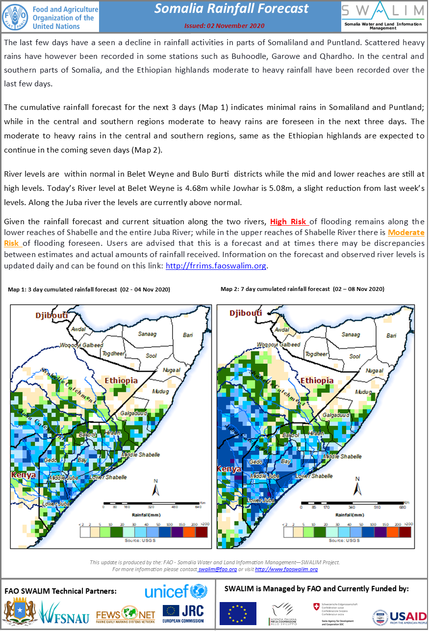
Somalia Rainfall Forecast - Issued: 02 November 2020
There has been a significant decline of rainfall amounts across Somalia over the last week. In the north western regions of Awdal, Wooqoyi Galbeed and Toghdheer, a prolonged dry period has been observed since the last week of September 2020. Most stations in these regions recorded little or no rainfall during the month of October 2020. Similarly, parts of Puntland have not received any rains since the first week of October. There also remains a significant rainfall deficit in most parts of the southern regions and especially the Jubas and Lower Shabelle.
The last week saw a reduction of river levels along the Shabelle River. Currently, levels are within normal in Belet Weyne and Bulo Burti districts while the mid and lower reaches are still at high levels. In Agfooye, the levels are at full capacity and most parts of the riverine areas remain inundated with massive displacement being reported in the area. River levels along the Juba increased sharply in the last one week reaching alarming levels in Bardheere. This was due to heavy rains in the upper reaches of the Ethiopian side which also led to river flooding in Dollow. The last three days have however seen a reduction of the levels along the channel.
The cumulative rainfall forecast for this week suggests a significant reduction of rainfall amounts across the country with light rains along the southern coastal areas. Little or no rainfall is foreseen in the Ethiopian highlands. This will subsequently lead to a decrease in river levels especially along the Shabelle river.
Given the rainfall forecast and current situation along the two rivers, flooding is likely to persist in Lower Shabelle riverine areas. There is no risk of flooding foreseen along the Juba River. There is however a great concern of moisture deficits across the country especially in the rain fed agricultural areas of the southern regions. Drought conditions are foreseen if the trend continues.
Publication Type:
Publication Date:
Author:
Corporate Author:
Somalia Rainfall Forecast - Issued 12 November 2020
There has been a significant decline of rainfall amounts across Somalia over the last week. In the north western regions of Awdal, Wooqoyi Galbeed and Toghdheer, a prolonged dry period has been observed since the last week of September 2020. Most stations in these regions recorded little or no rainfall during the month of October 2020. Similarly, parts of Puntland have not received any rains since the first week of October. There also remains a significant rainfall deficit in most parts of the southern regions and especially the Jubas and Lower Shabelle.
The last week saw a reduction of river levels along the Shabelle River. Currently, levels are within normal in Belet Weyne and Bulo Burti districts while the mid and lower reaches are still at high levels. In Agfooye, the levels are at full capacity and most parts of the riverine areas remain inundated with massive displacement being reported in the area. River levels along the Juba increased sharply in the last one week reaching alarming levels in Bardheere. This was due to heavy rains in the upper reaches of the Ethiopian side which also led to river flooding in Dollow. The last three days have however seen a reduction of the levels along the channel.
The cumulative rainfall forecast for this week suggests a significant reduction of rainfall amounts across the country with light rains along the southern coastal areas. Little or no rainfall is foreseen in the Ethiopian highlands. This will subsequently lead to a decrease in river levels especially along the Shabelle river.
Given the rainfall forecast, No risk of flooding is foreseen along the Juba and Shabelle rivers. There is however a great concern of moisture deficits across the country especially in the rain fed agricultural areas of the southern regions. Drought conditions are foreseen if the trend continues.
Publication Type:
Rainfall Forecast
Publication Date:
Author:
Corporate Author:
Pages
 RSS feed [compliant with the Agris AP] |
  Agris AP XML


