Library Catalog
Latest Documents and Publications listed. Use search terms in the box below to find what you need
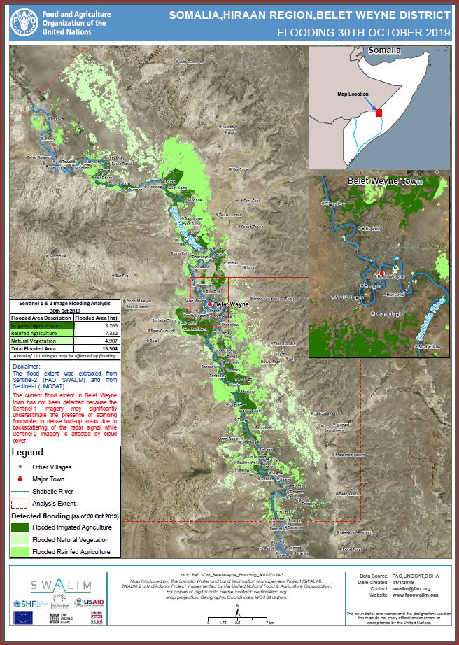
Belet Weyne District Flood Extent Map (As of 30 October 2019) - Issued 1 November 2019
The ongoing floods along the Shabelle River in Somalia has affected Belet Weyne District the worst. In Belet Weyne town, the river has remained at bankful level for the seventh day running. Flood waters have continued to ravage the town displacing more than 160,000 persons.
Analysis from satellite images indicate that a total of 15,504 Hectares have been inundated as of 30 October 2019. This includes 3,265 ha of irrigated agriculture, 7,332 ha of rain-fed agriculture and 4,907 ha of natural vegetation. A total of 111 settlements are also under water.
It is worth noting that the current flood extent in Belet Weyne town has not been detected due to the intrinsic nature of radar and optical images used (Sentinel-1 and 2 respectively). The Sentinel-1 imagery may significantly underestimate the presence of standing floodwater in dense built-up areas due to backscattering of the radar signal, while Sentinel-2 imagery is affected by cloud cover over Belet Weyne.
Publication Type:
Publication Date:
Author:
Corporate Author:
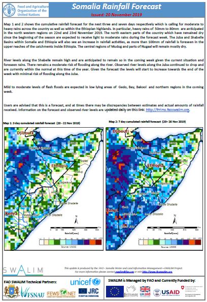
Somalia Rainfall Forecast: Issued 20 November 2019
The cumulative rainfall forecast for the next three and seven days is calling for moderate to heavy rains across the country as well as within the Ethiopian highlands. In particular, heavy rains of 50mm to 80mm are anticipated in the north western regions on 22nd and 23rd November 2019. The north eastern parts of the country which have remained dry since the beginning of the season are expected to receive light to moderate rains during the forecast week. The Juba and Shabelle Basins within Somalia and Ethiopia will also see an increase in rainfall activities, as more than 100mm of rainfall is foreseen in the upper reaches of the catchments inside Ethiopia. The central regions of Mudug and parts of Nugaal will remain mostly dry.
River levels along the Shabelle remain high and are anticipated to remain so in the coming week given the current situation and foreseen rains. There remains a moderate risk of flooding along the river. Observed river levels along the Juba continued to drop and are currently within the normal at this time of the year. Given the forecast the levels will start to increase towards the end of the week with minimal risk of flooding along the Juba.
Mild to moderate levels of flash floods are expected in low lying areas of Gedo, Bay, Bakool and northern regions in the coming week.
Publication Type:
Rainfall Forecast
Publication Date:
Author:
Corporate Author:

Somalia Rainfall Forecast: Issued 04 November 2019
The Deyr 2019 rains have so far been average to above average in many parts of the country apart from Bari, Nuugal and Mudug regions that have experienced below-average rains. The seasonal rains are expected to continue during November with moderate to heavy intensity.
During the last week, several places across the country recorded Light to moderate rains. A few places in the coastal areas of Bari and Nugal regions experienced moderate to heavy rains in the last 24Hours which led to flash floods and destruction of properties and death of livestock.
The cumulative rainfall forecast for the next three and seven days is calling for moderate to heavy rains across the country as well as within the Ethiopian highlands. Lower Juba and Bari regions may receive little or no rains.
Belet Weyne in Hiraan region has been at full bank level for the last 11 days leaving about 68% of the town underwater according to analysis from satellite images. Over the previous 24 hours, Bulo Burti reached the highest level in recent history. High levels and flooding in Belet Weyne and other areas along the Shabelle will be sustained in the next couple of days given the current situation and foreseen rains.
There was a reduction of river levels along the Juba River with no flood risk over the last week following a decrease in rainfall activities.
Flash floods are expected in low lying areas of Nuugal, Mudug, Bay and Bakool in the coming week given the rainfall forecast.
Publication Type:
Publication Date:
Author:
Corporate Author:
Somalia Flood Update - Issued 22 November 2019
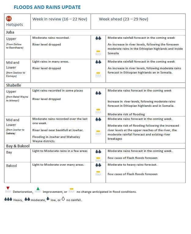
The Deyr rains continued into the second month of the season with a significant reduction over the last two weeks. However, the last few days have seen light to moderate amounts of rainfall in scattered areas across the country. The good rains received so far have continued to replenish water sources further improving pasture growth and reducing water stress. There has been an improvement in livestock body conditions and milk production as well.
Shabelle River: In Belet Weyne and surrounding areas, flood waters that invaded the town since the last week of October have now receded and the situation is getting back to normal notwithstanding the negative impacts left by the ravaging waters. River levels at a Belet Weyne, Bulo Burti and Jowhar as the well as the lower reaches of the river have been dropping gradually over the last week and are still above normal for this time of the year. The river levels are expected to remain high along the entire channel of Shabelle as more rains are foreseen in the Ethiopian highlands and inside Somalia. Moderate risk of flooding remains along the Shabelle in the coming week. Satellite image analysis indicate that more than 128,066 Hectares of land along the Shabelle of which more than 50% is agricultural land (80,041 ha) was inundated during the month of October and November.
Juba River: Along Juba River the levels dropped gradually over the last two weeks consequently reducing the flood impacts. Riverine floods along the Juba during the month of October and early November left a total of 79,229 Hectares of land inundated of which 29, 748 Hectares is agricultural land. This has damaged farmland and crops leading to livelihood losses. The levels are expected to fluctuate in the coming week with a Moderate risk of flooding towards the end of the week.
In Bay and Bakool regions: There was a reduction of rainfall activities in these regions over the previous weeks, which improved the situation in terms of flooding.
Puntland, Somaliland and Central regions: soma parts of Somaliland continued to record rains in the month of November while there were minimal rainfall activities in Puntland.
The rainfall forecast for the coming week shows continuing rainfall activities in many parts of Somalia and in the Ethiopian highlands. As a result, given the already saturated soil moisture there is a moderate risk of flooding along the two rivers. Flash floods will also be experienced in low-lying areas of Awdal, Woqooyi Galbeed Bakool, Bay and coastal areas of Galgaduud and Mudug regions.
No significant amount of rains area foreseen in Nuugal, Bari and Mudug regions. Hot and dry conditions are expected to persist in the coming week calling a cause for concern due to the prolonged dry period which may lead to depletion of water resources and pasture in the coming weeks.
Publication Type:
Flood watch bulletin
Publication Date:
Author:
Corporate Author:
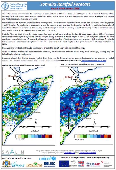
Somalia Rainfall Forecast: Issued 05 November 2019
The last 24 hours saw moderate to heavy rains in parts of Juba and Shabelle basins. Belet Weyne in Hiraan recorded 39mm, which has only made it worse for the town currently under water. Wanle Weyne in Lower Shabelle recorded 38mm. A few places in Nugaal and Mudug areas also received light rains.
Wet conditions are expected to persist in the coming weeks. The cumulative rainfall forecast for the next three and seven days is calling for moderate to heavy rains across the country as well as within the Ethiopian highlands. In particular heavy rains of more than 100mm are expected in Hiraan, Bay and Bakool regions which are already saturated following weeks of continued heavy rains. Lower Juba and Bari regions may receive little or no rains.
Shabelle River at Belet Weyne in Hiraan region has been at full bank level for the last 12 days leaving about 68% of the town underwater according to analysis from satellite images. Today, Bulo Burti in Hiraan Region is only 0.23m away from the bank full level pausing an immediate threat of overbank spillage and possible flooding of the town in the next few days. High levels and flooding in Belet Weyne and other areas along the Shabelle will be sustained in the next couple of days given the current situation and foreseen rains.
Observed river levels along the Juba continued to drop in the last 24 hours with no risk of flooding.
Given the rainfall forecast and antecedent soil moisture, flash floods are expected in low lying areas of Nuugal, Mudug, Bay and Bakool Regions in the coming week.
Publication Type:
Rainfall Forecast
Publication Date:
Author:
Corporate Author:
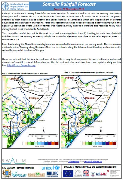
Somalia Rainfall Forecast: Issued 26 November 2019
Rainfall of moderate to heavy intensities has been received in several locations across the country. The heavy downpour which started on 22 to 26 November 2019 led to flash floods in some places. Some of the places affected by flash floods include Erigavo and Zeylac districts in Somaliland which saw displacement of several households and destruction of property. Parts of Mogadishu were also flooded following a heavy downpour in the night of 25 November where 78mm of rainfall was recorded. Many stations in Puntland also recorded heavy rains during the last week which led to flash floods.
The cumulative rainfall forecast for the next three and seven days is calling for a reduction of rainfall activities across the country as well as within the Ethiopian highlands with little or no rains expected after 27 November 2019.
River levels along the Shabelle remain high and are anticipated to remain so in the coming week. There remains a moderate risk of flooding along the river. Observed river levels along the Juba continued to drop and are currently within the normal at this time of the year.
Publication Type:
Rainfall Forecast
Publication Date:
Author:
Corporate Author:
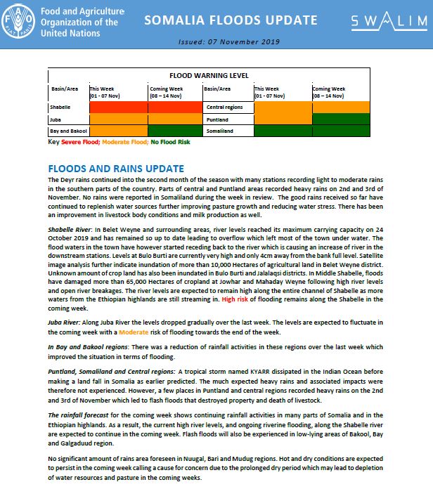
Somalia Flood Update - Issued 07 November 2019
The Deyr rains continued into the second month of the season with many stations recording light to moderate rains in the southern parts of the country. Parts of central and Puntland areas recorded heavy rains on 2nd and 3rd of November. No rains were reported in Somaliland during the week in review. The good rains received so far have continued to replenish water sources further improving pasture growth and reducing water stress. There has been an improvement in livestock body conditions and milk production as well.
Shabelle River: In Belet Weyne and surrounding areas, river levels reached its maximum carrying capacity on 24 October 2019 and has remained so up to date leading to overflow which left most of the town under water. The flood waters in the town have however started receding back to the river which is causing an increase of river in the downstream stations. Levels at Bulo Burti are currently very high and only 4cm away from the bank full level. Satellite image analysis further indicate inundation of more than 10,000 Hectares of agricultural land in Belet Weyne district. Unknown amount of crop land has also been inundated in Bulo Burti and Jalalaqsi districts. In Middle Shabelle, floods have damaged more than 65,000 Hectares of cropland at Jowhar and Mahaday Weyne following high river levels and open river breakages. The river levels are expected to remain high along the entire channel of Shabelle as more waters from the Ethiopian highlands are still streaming in. High risk of flooding remains along the Shabelle in the coming week.
Juba River: Along Juba River the levels dropped gradually over the last week. The levels are expected to fluctuate in the coming week with a Moderate risk of flooding towards the end of the week.
In Bay and Bakool regions: There was a reduction of rainfall activities in these regions over the last week which improved the situation in terms of flooding.
Puntland, Somaliland and Central regions: A tropical storm named KYARR dissipated in the Indian Ocean before making a land fall in Somalia as earlier predicted. The much expected heavy rains and associated impacts were therefore not experienced. However, a few places in Puntland and central regions recorded heavy rains on the 2nd and 3rd of November which led to flash floods that destroyed property and death of livestock.
The rainfall forecast for the coming week shows continuing rainfall activities in many parts of Somalia and in the Ethiopian highlands. As a result, the current high river levels, and ongoing riverine flooding, along the Shabelle river are expected to continue in the coming week. Flash floods will also be experienced in low-lying areas of Bakool, Bay and Galgaduud region.
No significant amount of rains area foreseen in Nuugal, Bari and Mudug regions. Hot and dry conditions are expected to persist in the coming week calling a cause for concern due to the prolonged dry period which may lead to depletion of water resources and pasture in the coming weeks.
Publication Type:
Publication Date:
Author:
Corporate Author:
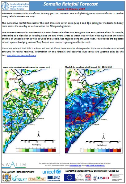
Somalia Rainfall Forecast: Issued 16-10-2019
Moderate to heavy rains continued in many parts of Somalia. The Ethiopian highlands also continued to receive heavy rains in the last few days.
The cumulative rainfall forecast for the next three and seven days is calling for moderate to heavy rains across the country as well as within the Ethiopian highlands.
The foreseen heavy rains may lead to a further increase in river flow along the Juba and Shabelle Rivers in Somalia, translating to a high risk of flooding along the two rivers. Areas to watch out for river flooding include the entire channel of Shabelle River as well as Gedo and Middle Juba regions along the Juba River. Flash floods are expected in built-up and low lying areas of Bay, Bakool and central regions given the forecast.
Publication Type:
Publication Date:
Author:
Corporate Author:
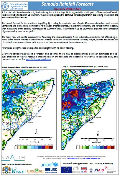
Somalia Rainfall Forecast: Issued 02-10-2019
A few places in Somalia received light rains during the last few days. Gedo region in the south, parts of Puntland and Somaliland recorded light rains of up to 20mm. The season is expected to continue spreading further in the coming weeks until the end of season in November.
The rainfall forecast for the next three days is calling for moderate rains of up to 40mm cumulatively in most parts of Somaliland and a few places in Puntland. As the week progresses the rains will intensify and spread further in space, with many parts of the country recording 50 to 100mm in total. Heavy rains of up to 150mm are expected in the Ethiopian highlands during the forecast period.
The heavy rains will lead to increased river flow along the Juba and Shabelle Rivers in Somalia. A moderate risk of flooding remains in the middle reaches of Shabelle river. Areas to watch out for floods include Mahadey Weyne, Jowhar, and Balcad districts riverine areas where there exist several open river banks and weak river embankments.
River levels along the Juba are expected to rise slightly with no risk of flooding.
Publication Type:
Rainfall Forecast
Publication Date:
Author:
Corporate Author:
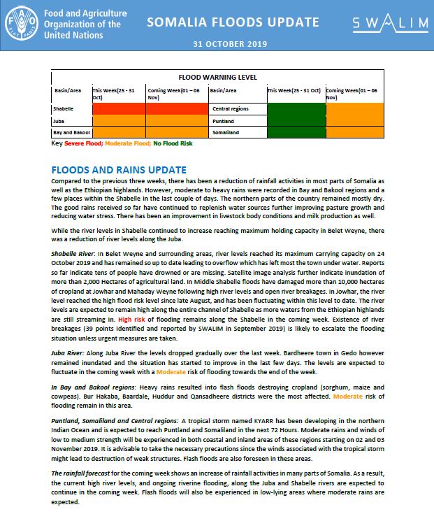
Somalia Flood Update - Issued 31 October 2019
Compared to the previous three weeks, there has been a reduction of rainfall activities in most parts of Somalia as well as the Ethiopian highlands. However, moderate to heavy rains were recorded in Bay and Bakool regions and a few places within the Shabelle in the last couple of days. The northern parts of the country remained mostly dry. The good rains received so far have continued to replenish water sources further improving pasture growth and reducing water stress. There has been an improvement in livestock body conditions and milk production as well.
While the river levels in Shabelle continued to increase reaching maximum holding capacity in Belet Weyne, there was a reduction of river levels along the Juba.
Shabelle River: In Belet Weyne and surrounding areas, river levels reached its maximum carrying capacity on 24 October 2019 and has remained so up to date leading to overflow which has left most the town under water. Reports so far indicate tens of people have drowned or are missing. Satellite image analysis further indicate inundation of more than 2,000 Hectares of agricultural land. In Middle Shabelle floods have damaged more than 10,000 hectares of cropland at Jowhar and Mahaday Weyne following high river levels and open river breakages. In Jowhar, the river level reached the high flood risk level since late August, and has been fluctuating within this level to date. The river levels are expected to remain high along the entire channel of Shabelle as more waters from the Ethiopian highlands are still streaming in. High risk of flooding remains along the Shabelle in the coming week. Existence of river breakages (39 points identified and reported by SWALIM in September 2019) is likely to escalate the flooding situation unless urgent measures are taken.
Juba River: Along Juba River the levels dropped gradually over the last week. Bardheere town in Gedo however remained inundated and the situation has started to improve in the last few days. The levels are expected to fluctuate in the coming week with a Moderate risk of flooding towards the end of the week.
In Bay and Bakool regions: Heavy rains resulted into flash floods destroying cropland (sorghum, maize and cowpeas). Bur Hakaba, Baardale, Huddur and Qansadheere districts were the most affected. Moderate risk of flooding remain in this area.
Puntland, Somaliland and Central regions: A tropical storm named KYARR has been developing in the northern Indian Ocean and is expected to reach Puntland and Somaliland in the next 72 Hours. Moderate rains and winds of low to medium strength will be experienced in both coastal and inland areas of these regions starting on 02 and 03 November 2019. It is advisable to take the necessary precautions since the winds associated with the tropical storm might lead to destruction of weak structures. Flash floods are also foreseen in these areas.
The rainfall forecast for the coming week shows an increase of rainfall activities in many parts of Somalia. As a result, the current high river levels, and ongoing riverine flooding, along the Juba and Shabelle rivers are expected to continue in the coming week. Flash floods will also be experienced in low-lying areas where moderate rains are expected.
Publication Type:
Publication Date:
Author:
Corporate Author:
Pages
 RSS feed [compliant with the Agris AP] |
  Agris AP XML