Library Catalog
Latest Documents and Publications listed. Use search terms in the box below to find what you need
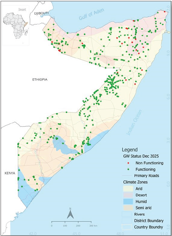
Somalia Groundwater Status Update - Issued 23 December 2025
Groundwater remains Somalia’s most critical and dependable water source, sustaining urban and rural populations, pastoral livelihoods, and productive sectors especially as surface water availability continues to decline during the ongoing drought. SWALIM has finalized the December 2025 Groundwater Status Update which indicates that aquifer conditions across the country are strongly driven by seasonal rainfall and are increasingly stressed by recurrent drought, high temperatures, and rising abstraction. Significant groundwater declines were recorded in parts of Somaliland and Puntland following poor Deyr 2025 rains, while central and southern regions generally maintained more stable conditions. Groundwater quality trends closely mirrored water-level changes, with higher salinity during periods of depletion and improvements following seasonal recharge, underscoring the close link between climate variability, aquifer dynamics, and water quality
Despite these pressures, weekly monitoring data indicates that most strategic boreholes remain functional, particularly in south-central Somalia, ensuring continued access to water during the early Jilaal dry season. However, localized mechanical failures mainly related to pumps, power supply, and riser pipes have concentrated abstraction on fewer water points in Puntland and Somaliland, accelerating aquifer stress and contributing to rising water prices in some regions.
Persistently low river levels along the Shabelle and Juba rivers have further increased dependence on groundwater for domestic use, irrigation, and water trucking. With hot and dry Jilaal conditions expected to persist and uncertainty surrounding the Gu 2026 rains, sustained groundwater monitoring, rapid rehabilitation of non-functioning boreholes, and strengthened demand management remain essential to mitigate escalating water stress and support informed humanitarian and development responses
Publication Type:
Newsletter
Publication Date:
Author:
Corporate Author:
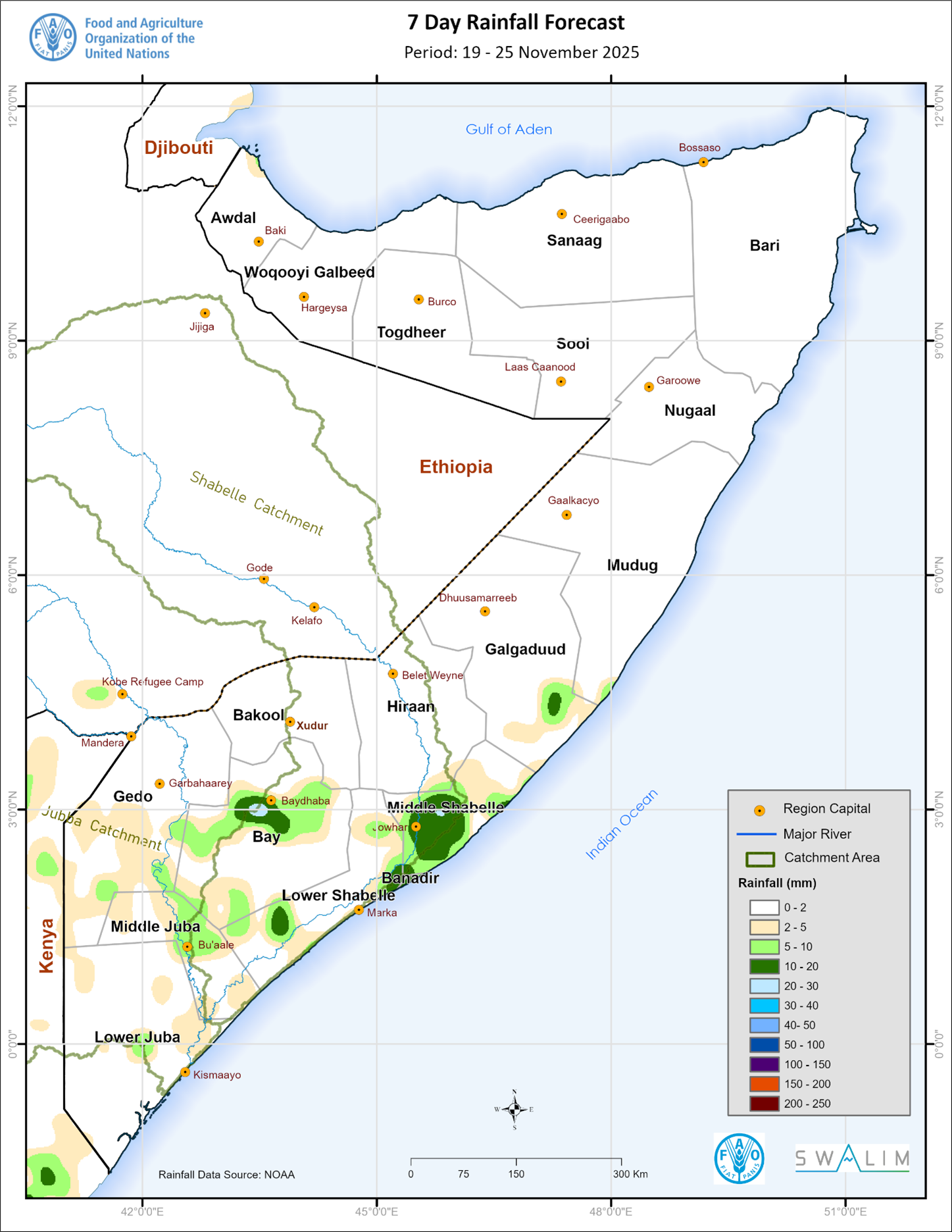
Somalia Rainfall Forecast – Issued 19 November 2025
According to NOAA-NCEP GFS, light rains are likely over some areas in the south with dry conditions expected to prevail in most other parts of the country, particularly Somaliland and Puntland (Figure 2). The rains in the south may be of moderate intensity over isolated areas in Bay, Lower Shabelle, Banadir, and Middle Shabelle regions, and over the coastal parts of both Galgaduud and Mudug. These light to moderate rain is likely to be observed between 22 and 24 November 2025.
Publication Type:
Rainfall Forecast
Publication Date:
Author:
Corporate Author:
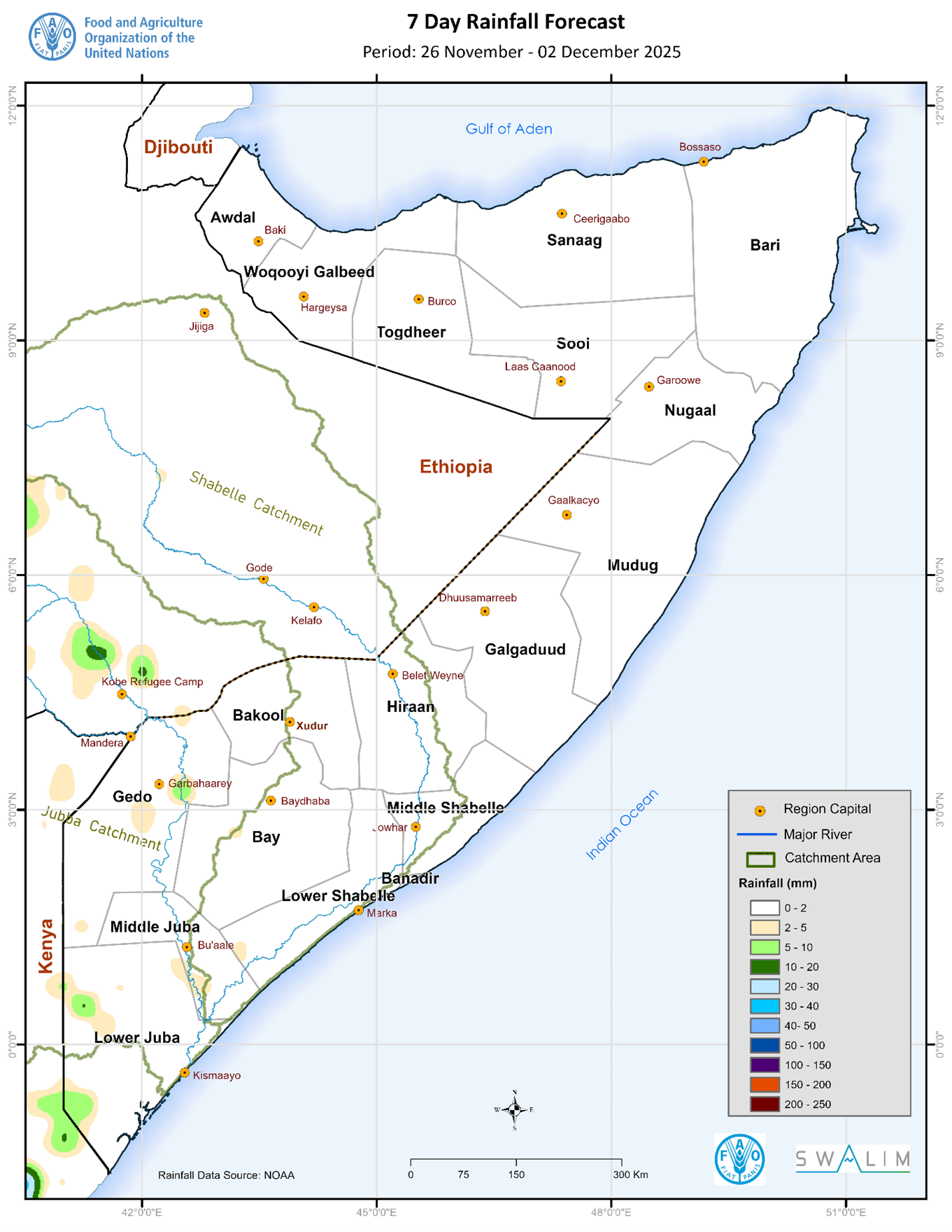
Somalia Rainfall Forecast – Issued 26 November 2025
Based on NOAA-NCEP GFS, dry conditions are expected to prevail in most parts of the country with chances of very light rains in some parts of Jubaland (Figure 1). Dry conditions are also expected over the entire Shabelle River catchment. Light isolated rains are expected over the Juba River catchment within and outside Somalia.
Publication Type:
Rainfall Forecast
Publication Date:
Author:
Corporate Author:
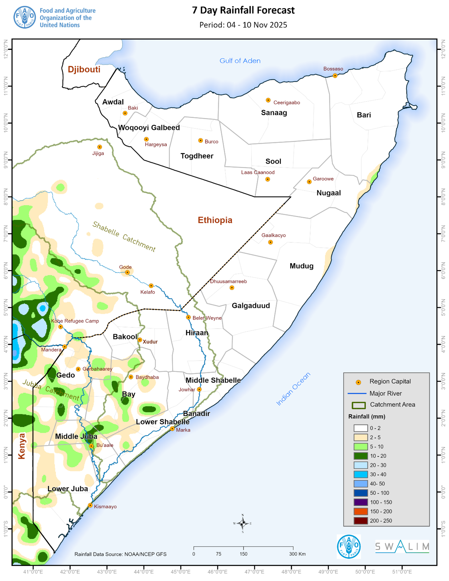
Somalia Rainfall Forecast – Issued 4 November 2025
Based on climatology, the month of November marks the peak of Deyr rains. However, according to NOAA-NCEP GFS, dry conditions are expected to prevail in most parts of the country, particularly northern and central parts during the coming week (Figure 1). Light rains are likely over few isolated areas in Bay, Gedo, Middle Juba and Lower Juba regions, and Sablaale district in Lower Shabelle region. The present status of the Madden Julian Oscillation (MJO) index is strong but out-of-phase and is therefore not likely to favor any significant rain during the forecast period.
Publication Type:
Rainfall Forecast
Publication Date:
Author:
Corporate Author:
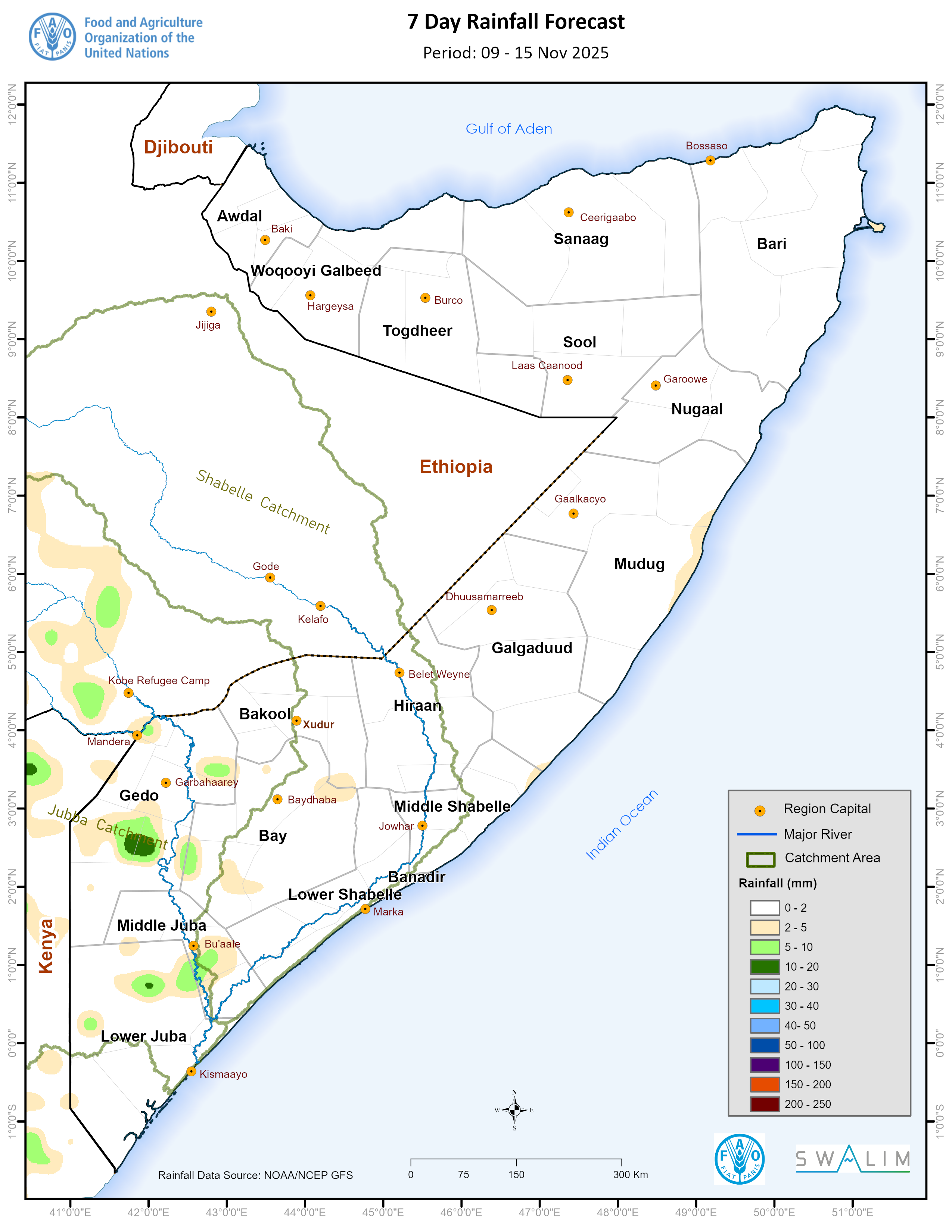
Update on the Juba and Shabelle River Levels - Issued 9 November 2025
Based on climatology, the first week of November represents the climax of the Deyr rainfall season. So far into the season, Deyr rains have been below normal across most parts of the country. Given that the Madden Julian Oscillation (MJO) index (Figure 5) is out-of-phase, and as confirmed by the NOAA GFS (Figure 4), dry conditions are forecast over Somalia including the entire Juba and Shabelle River catchments in the coming week. The Deyr season may actually come to an end in the coming two weeks ushering in the hot and dry Jilaal season.
Based on the available observed and forecast data, the likelihood of flooding along both Juba and Shabelle Rivers remain low.
Publication Type:
Flood Alert
Publication Date:
Author:
Corporate Author:
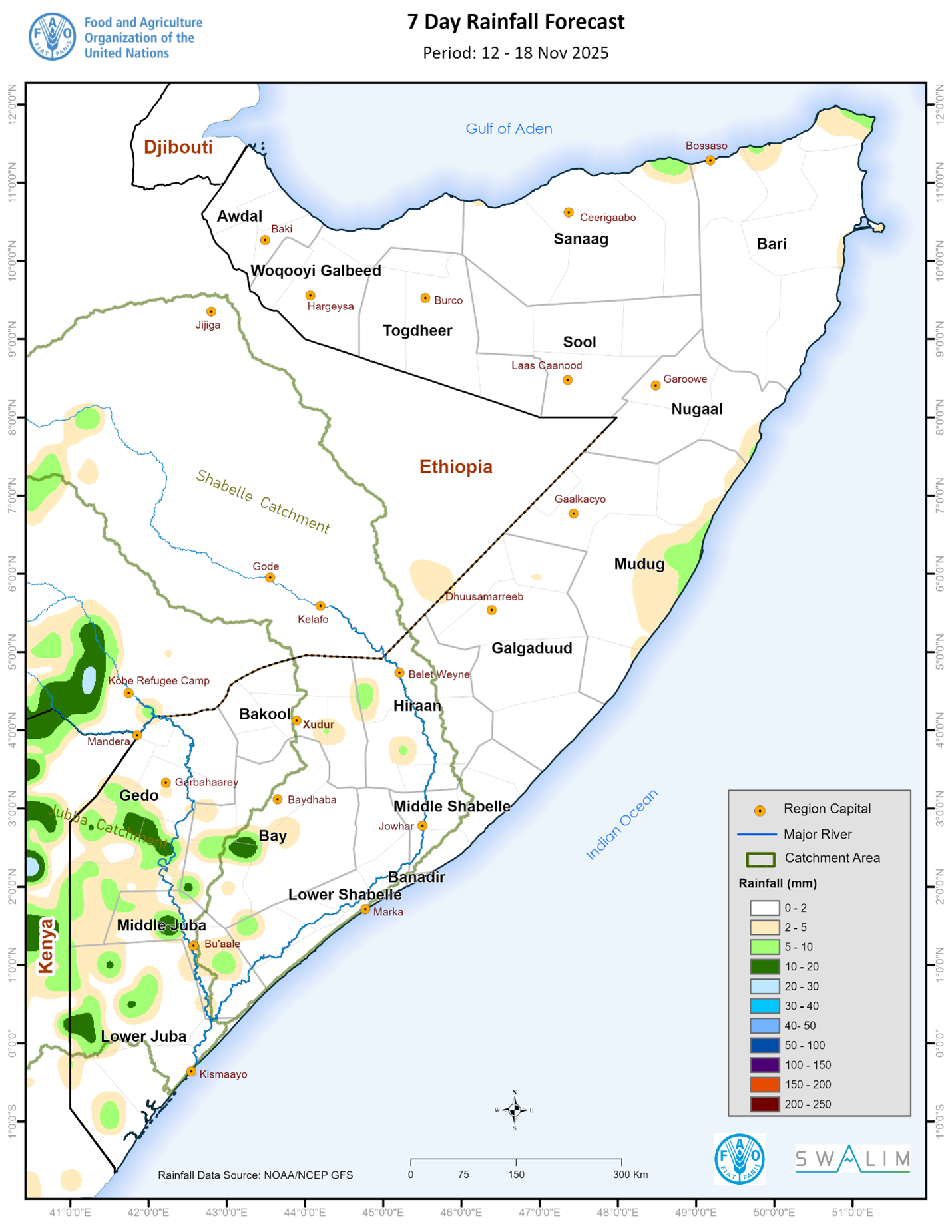
Somalia Rainfall Forecast – Issued 13 November 2025
According to NOAA-NCEP GFS, dry conditions are expected to prevail in most parts of the country, particularly northern and central parts during the third week of November (Figure 2). Light rains are likely over few isolated areas in Lower Juba, Middle Juba, Gedo, and Bay regions, and coastal parts of the following areas: Hobyo district in Mudug region, Caluul and Bosasso districts in Bari region, and Laasqoraay in Sanaag region. The Madden Julian Oscillation (MJO) index is presently strong but out-of-phase and is therefore not likely to favor any significant rain during the forecast period.
Publication Type:
Rainfall Forecast
Publication Date:
Author:
Corporate Author:
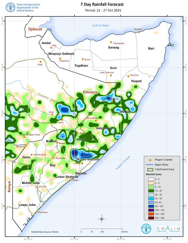
Somalia Rainfall Forecast – Issued 22 October 2025
According to NOAA-NCEP GFS, rainfall is expected over some parts of central Somalia with moderate intensity in parts of Hiraan, Middle Shabelle and Mudug regions. The north and southmost parts of the country are expected to remain dry. The spatial spread of the forecast rainfall conditions is as follows (Figure 1):
Heavy rainfall of above 100 mm is likely over western parts of Bulo Burte district in Hiraan region.
Moderate rainfall of between 50 and 100 mm is forecast over Jalalaqsi district in Hiraan region; northern parts of both Jowhar and Cadale districts in Middle Shabelle region; northern parts of Wanla Weyn district in Lower Shabelle region; Galdogob and western parts of Galkacyo district in Mudug region; and northeastern border areas of Xudur district with Ceel Barde district in Bakool region. The middle sections of the Shabelle River catchment within Somalia and its upper catchments in Ethiopia is also likely to observe rains of moderate amounts.
Light rainfall of less than 50 mm is expected over most parts of Belet Weyne district in Hiraan region; Galkacyo, Hobyo and Xaradheere districts in Mudug region; Ceel Buur district in Galgaduud region; Adan Yabaal district in Middel Shabelle region; Wanla Weyn district in Lower Shabelle region; northern parts of Xudur district, eastern parts of Ceel Barde district and northern parts of Tayeeglow district in Bakool region; Ceel Waaq district and northern parts of Baardheere district in Gedo region and some localized parts of Bay region. Rainfall of lighter intensity is likely to be observed in areas adjacent to the above districts and regions including the middle sections of the Juba River catchment within Somalia and upper catchments outside the country. Most parts of the Shabelle River catchment in the Somalia-Ethiopia border are likely to receive similarly light rains.
Dry conditions are likely over most parts of Somaliland including Awdal, Woqooyi Galbeed, Togdheer, Sool and Sanaag regions; Bari, Nugaal, Lower Juba, Middle Juba, Bay and Banadir regions; Belet Xaawo, Dollow and Luuq districts in Gedo region; Rab Dhuure and Waajid districts and southern parts of Xudur district in Bakool region; Sablaale, Baraawe, Kurtunwaarey, Qoryooley, Marka and Afgooye districts in Lower Shabelle region; Balcad district in Middle Shabelle region; central parts both Ceel Dheer and Ceel Buur districts and eastern parts of Dhuusamarreeb district in Galgaduud region; and Jariiban district in Mudug region. Similar dry conditions are likely over most areas in the lower sections of the Juba River catchment within Somalia.
Publication Type:
Rainfall Forecast
Publication Date:
Author:
Corporate Author:
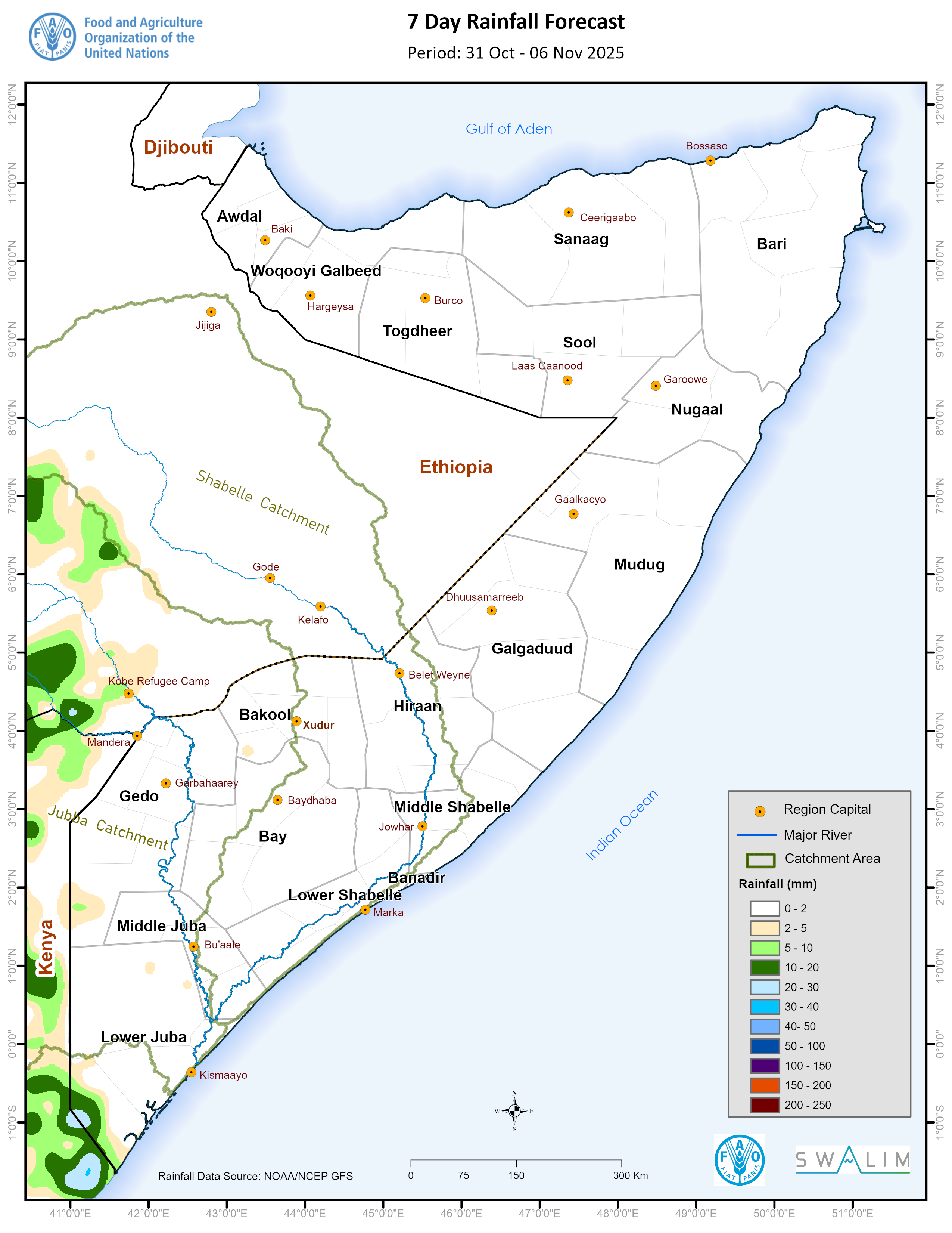
Somalia Rainfall Forecast – Issued 31 October 2025
Dry conditions are expected to prevail in most parts of the country, particularly in the northern and central parts during the coming week according to NOAA-NCEP GFS forecast (Figure 1). Synoptic forecast show that light rains are likely to be observed in Badhaadhe and Afmadow district in Lower Juba region, Saakow district in Middle Juba region, Bardheere and Ceel Waaq districts in Gedo region, and Buur Hakab district in Bay region. While most forecasts anticipate similar distribution of rain, ICPAC anticipates relatively intense rains particularly in some parts of Gedo and Bay region.
Publication Type:
Rainfall Forecast
Publication Date:
Author:
Corporate Author:
Deyr 2025 Seasonal Climate Outlook - Issued 6 October 2025
After the GHACOF-71, the 2nd National Climate Outlook Forum (NCOF) for the October–December (Deyr) 2025 season was convened in Mogadishu, Somalia, from 2nd to 3rd September 2025 under the theme “Climate Science and Forecasting for a Resilient The major highlights were; Poor and late Deyr rains: Most of Somalia is forecast to receive below-normal rainfall, with a delayed onset, especially in the south. Hotter than usual: Above-average temperatures will worsen drought, water stress, and health risks Northern drought persists: Conditions in Somaliland and Puntland are expected to deteriorate further. Flood risks remain: Despite the dry forecast, localized flash floods and river overflows remain a threat in flood-prone areas Livelihoods at risk: Short and erratic rains will limit farming recovery and stress livestock. Therefore, urgent need for drought response in the north, safeguarding gains in the south, proactive flood, water, and health preparedness
Publication Type:
Rainfall Outlook
Publication Date:
Author:
Corporate Author:
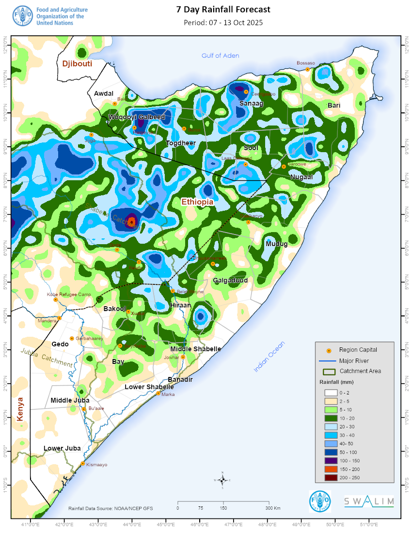
Somalia Rainfall Forecast – Issued 8 October 2025
Based on the ICPAC seasonal forecast, the Deyr rains are likely to begin in the first dekad of October in Togdheer, Sool and Nugaal regions. According to NOAA-NCEP GFS, widespread light rainfall is expected over most parts of Woqooyi Galbeed, Togdheer, Sool, Sanaag and Hiraan regions and some inland parts of Nugaal, Mudug, and Galgaduud regions. The spatial spread of the forecast rainfall conditions are as follows:
Moderate rainfall of between 50.0 and 100.0 mm is forecast over northern parts of Hargeisa districts in Woqooyi Galbeed region; northern parts of Ceerigaabo district in Sanaag region; southwestern parts of Qardo district in Bari region; eastern parts of Bulo Burte district in Hiraan region; western and eastern parts of Buuhodle district in Togdheer region; and western parts of Laas Caanood district in Sool region. The intensity of the rains over northern parts of both Hargeisa and Ceerigaabo districts may lead up to more than 100 mm at the end of the forecast week. Heavy rainfall above 150 mm is likely over the upper catchments of Shabelle River in Ethiopia in the far north-eastern highlands of Gode city.
Light rainfall of less than 50.0 mm is expected over most other parts of Woqooyi Galbeed, Togdheer, Sool, and Sanaag regions; and most other parts of Qardo, Bulo Burte, Buuhodle, and Laas Caanood districts. Similarly light rains are also expected over most parts of Borama and Baki districts in Awdal region; Qandala and Bandarbeyla districts in Bari region; Garowe and Burtinle districts in Nugaal region; Galkacyo district and inland parts of bothJ ariiban and Hobyo districts in Mudug region; Cadaado, Dhuusamarreeb and Cabudwaaq districts in Galgaduud region; Belet Weyne district in Hiraan region; Ceel Barde and Tayeglow districts in Bakool region and Baydhaba district in Bay region. Similar light rains are expected over the Shabelle River catchment within Somalia.
Dry conditions are likely over most parts of the following regions: Lower Juba, Middel Juba, Gedo, Lower Shabelle, and Middel Shabelle. Similar conditions are expected over Dinsoor district in Bay region; Rab Dhuure and Waajid districts in Bakool region; Ceel Dheer and Xaradheere districts in Galgaduud region; coastal parts of both Hobyo and Jariiban districts in Mudug region; coastal parts of Eyl district in Nugaal region; Iskushuban, Caluula and Bossaso districts in Bari region; and Zeylac and Lughaye districts in Awdal region. Similar dry conditions are likely over most areas over the Juba River catchment within and outside Somalia.
Publication Type:
Rainfall Forecast
Publication Date:
Author:
Corporate Author:
Pages
 RSS feed [compliant with the Agris AP] |
  Agris AP XML