Library Catalog
Latest Documents and Publications listed. Use search terms in the box below to find what you need
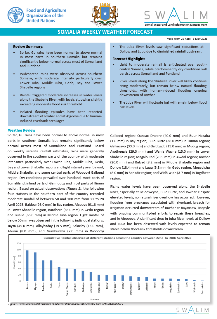
Somalia Rainfall Forecast – Issued 07 May 2025
Light to moderate rains is expected across central and southern regions this week, with intense storms possible in Middle Shabelle and Galgaduud. Dry and hot conditions persist in Puntland and Awdal, raising heat stress and water scarcity concerns. Rainfall prospects remain favorable for most of May.
Publication Type:
Rainfall Forecast
Publication Date:
Author:
Corporate Author:
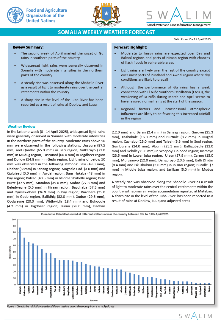
Somalia Rainfall Forecast – Issued 16 April 2025
According to the NOAA-NCEP Global Forecasting System (GFS) forecast, moderate (50 – 100 mm) to heavy rains (100 – 150 mm)are expected over Bay and Bakool regions and parts of Hiraan region. Light rains (less than 50 mm) are likely over the rest of the country except over most parts of Puntland and Awdal region where dry conditions are likely to prevail. Although the current and forecast position of Madden Julian Oscillation (MJO) index is outside the region of influence, the rains over Bay and Bakool may cumulate to more than 150 mm by the end of the forecast period. Other regional factors and intraseasonal atmospheric influences are likely to be favoring this increased onshore moisture transports and rainfall in the region. Although the performance of Gu rains has a weak connection with El nino southern Oscillation (ENSO), the weakening of La Niña during March and April seems to have favored moderate rains at the start of the season.
The temporal and spatial distribution of the forecast rainfall (Map 2) are as follows:
Light cumulative rainfall of less than 50 mm is forecast over several areas in the country including most parts of Togdheer, Sool, Galgaduud, Middle Juba and Banadir regions; southern parts of Hargeysa district in Woqooyi Galbeed region; Ceerigaabo district in Sanaag region; some isolated parts in the western parts of Qardho district in Bari region; northern parts of Garoowe district and western parts of Burtinle District in Nugaal region; Gaalkacyo, Galdogob and Xarardheere districts and southern parts of Hobyo district in Mudug region; Jalalaqsi district and northern parts of both Belet Weyne and Bulo Burte districts in Hiraan region; northern parts of both Jowhar and Adan Yabaal districts and coastal parts of both Balcad and Adan Yabaal districts in Middle Shabelle region; eastern parts of both Wanla Weyn and Afgooye districts in Lower Shabelle region; western parts of Qansax Dheere district and southern parts of Dinsoor district in Bay region; Doolow district and southern parts of Baardheere district in Gedo region; Jamaame district, northern parts of Kismaayo district and southern parts of Afmadow district in Lower Juba region.
Moderate cumulative rainfall of 50 mm to 100 mm is likely to occur over most parts of Bay region particularly Buur Hakaba district; most parts of Bakool region including Rab Dhuure and Ceel Barde districts; and most parts of Lower Shabelle region particularly Marka and Baraawe districts, southern parts of Sablaale district, and western parts of both Wanla Weyn and Afgooye districts; Luuq, Belet Xaawo and Garbahaarey districts, northern parts of both Ceel Waaq and Baardheere districts; south-eastern parts of Afmadow district; western parts of both Belet Weyne districts in Hiraan region; Middle Shabelle region particularly Cadale district, central parts of Jowhar, and inland parts of Balcad district; areas at the border of Ceel Buur and Dhuusamarreeb districts in Galgaduud region. It is important to note that similar moderate rains will also be observed over several parts of both Shabelle and Juba River catchments within the country and in Ethiopia.
Heavy cumulative rainfall of between 100 and 150 mm is likely to be observed over most parts of Baydhaba district and northern parts of Buur Hakaba district in Bay region; eastern parts of Luuq district in Gedo region; Waajid, Xudur and Tayeeglow districts in Bakool region; western parts of Bulo Burte district in Hiraan region.
Very heavy cumulative rainfall of over 150 mm is likely to be observed over some northern parts of Baydhaba district in Bay region; Xudur district and southern parts of Tayeeglow district in Bakool region. There is a chance that the rains over these areas may exceed 200 mm by the end of the forecast period. Daily forecasts suggest that much of these rains may be observed on the 18 and 19 April with likelihood of flash flooding over prone areas.
Dry conditions are likely to prevail over most parts Awdal and Bari regions; most parts of Lower Juba region particularly Badhaadhe district; Jariiban district in Mudug region, most parts of Nugaal region particularly Eyl district and eastern parts of Garoowe districts; some parts of Sanaag region particularly Ceel Afweyn district, northern parts of Laasqoray district and the coastal parts of Ceerigaabo district; and most parts of Woqooyi Galbeed region particularly Berbera and Gebiley districts and northern parts of Hargeisa district.
Publication Type:
Rainfall Forecast
Publication Date:
Author:
Corporate Author:
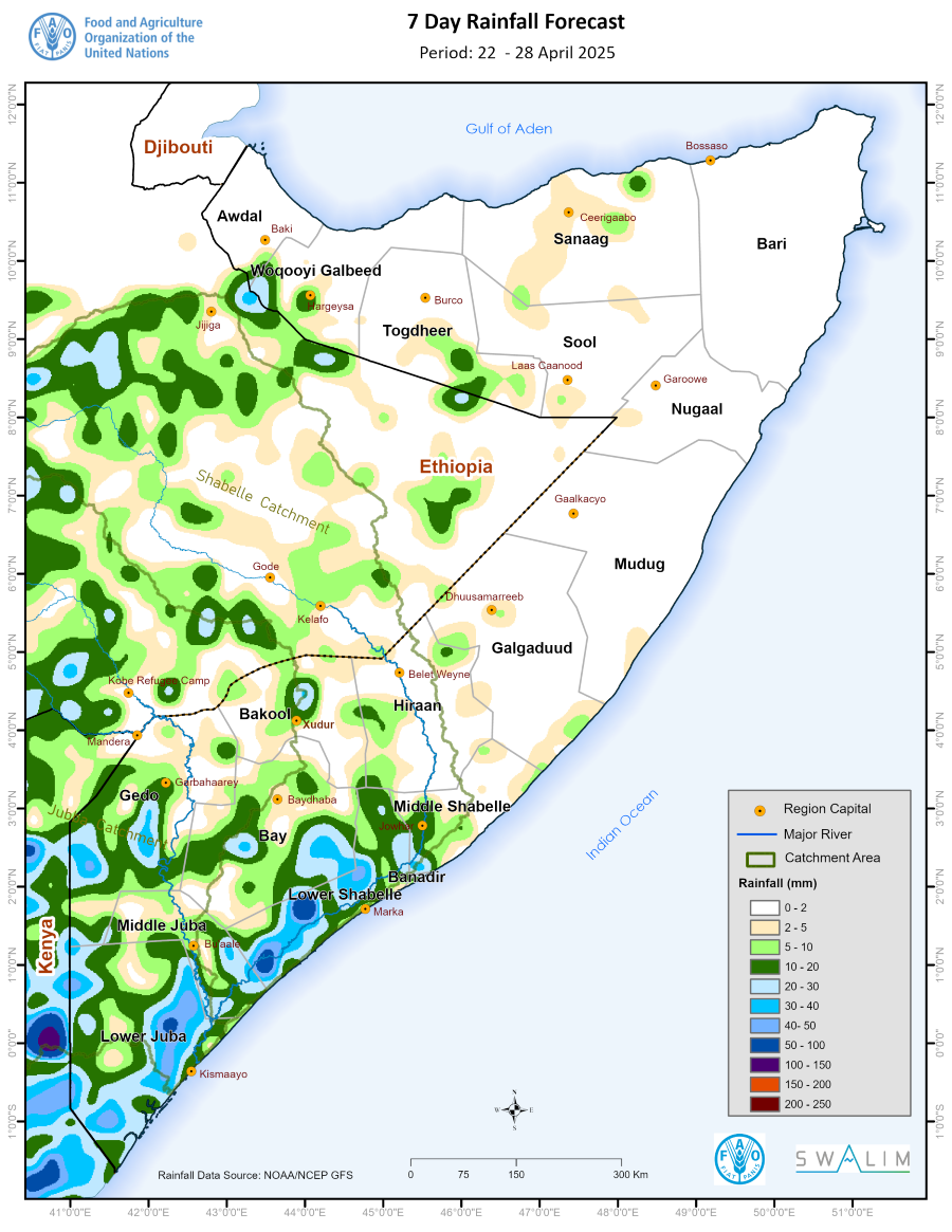
Somalia Rainfall Forecast – Issued 23 April 2025
Based on the NOAA-NCEP Global Forecasting System (GFS) forecast, light to moderate rain is expected over several areas in the southern parts of the country with dry conditions expected to prevail over Somaliland and Puntland. The temporal and spatial distribution of the forecast rainfall (Map 1) are as follows:
Light cumulative rainfall of less than 50 mm is forecast over several areas in the southern parts of the country including most parts of Lower Juba, Middle Juba, Bay, and Lower Shabelle regions; some parts of Gedo particularly Ceel Waaq and Bardheere districts; parts of Middle Shabelle region particularly Jowhar and Balcad districts; parts of Bakool region particularly Xudur and Ceel Barde districts; western parts of Belet Weyne district in Hiraan region; southern parts of Gebiley district and Hargeisa town in Woqooyi Galbeed region; Buuhoodle district and southern parts of Burco district in Togdheer region; northern coastal parts of Laasqoray district in Sanaag region. It is important to note that such rains are likely to fall over the Juba River catchment within and outside the country. While the rains over the upper and central catchment of the Shabelle River will be very light, they may increase in intensity over the lower sections in Middle Shabelle including Jowhar.
Moderate cumulative rainfall of 50 mm to 100 mm is likely to occur over isolated areas in Lower Juba region particularly southern parts of Afmadow district; and areas bordering Sablaale and Baraawe districts and northern border areas of Kurtunwarey and Qoryooley districts in Lower Shabelle region. It is important to note that intense but isolated rains of above 100 mm may be observed over areas in Lower Juba bordering Kenya.
Dry conditions are likely to prevail over most parts Awdal, Woqooyi Galbeed, Togdheer, Sanaag, Sool, Bari, Nugaal, Mudug and Galgaduud regions; most parts of Hiraan region particularly Bulo Burte and Jalaqsi districts and eastern parts of Belet Weyne; eastern parts of Middle Shabelle region particularly Adan Yabaal district and the northern parts of Cadale district; and some parts of Bakool region particularly Waajid, Rab Dhuure and Tayeeglow districts.
Publication Type:
Rainfall Forecast
Publication Date:
Author:
Corporate Author:
Shabelle River Flood Situation at Jowhar Issued 28-04-2025
Flooding reported at Bayaxaaw and Raqayle villages downstream of Jowhar town. The floods have primarily resulted from a breakage, reported to have been created by riverine farmers diverting river water into irrigation canals during the recent dry spells. Communities in the affected villages are making efforts to close the breakage, but they have not succeeded so far.
Although the river level at Jowhar gauging station has surpassed the moderate flood-risk threshold, no natural river overbank flows have been observed yet.
Publication Type:
Flood Alert
Publication Date:
Author:
Corporate Author:
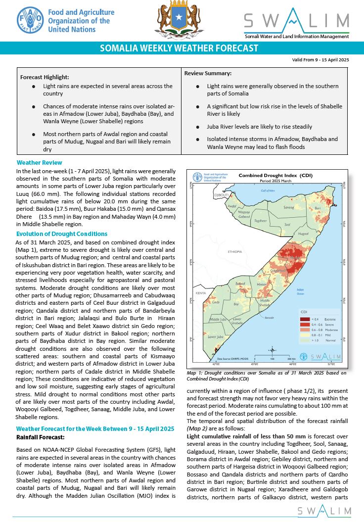
Somalia Rainfall Forecast – Issued 10 April 2025
Based on NOAA-NCEP Global Forecasting System (GFS), light rains are expected in several areas in the country with chances of moderate intense rains over isolated areas in Afmadow (Lower Juba), Baydhaba (Bay), and Wanla Weyne (Lower Shabelle) regions. Most northern parts of Awdal region and coastal parts of Mudug, Nugaal and Bari will likely remain dry. Although the Madden Julian Oscillation (MJO) index is currently within a region of influence ( phase 1/2), its present and forecast strength may not favor very heavy rains within the forecast period. Moderate rains cumulating to about 100 mm at the end of the forecast period are possible.
The temporal and spatial distribution of the forecast rainfall are as follows:
Light cumulative rainfall of less than 50 mm is forecast over several areas in the country including Togdheer, Sool, Sanaag, Galgaduud, Hiraan, Lower Shabelle, Bakool and Gedo regions; Borama district in Awdal region; Gebiley district, northern and southern parts of Hargeisa district in Woqooyi Galbeed region; Bossaso and Qandala districts and northern parts of Qardho district in Bari region; Burtinle district and southern parts of Garowe district in Nugaal region; Xaradheere and Galdogob districts, northern parts of Galkacyo district, western parts of Hobyo district in Mudug region; Jowhar and Adan Yabaal districts in Middle Shabelle region; and Qansax Dheere and northern parts of Buur Hakaba district in Bay region. It is important to note that such light rains are also likely over the upper catchments of Juba River in Ethiopia.
Moderate cumulative rainfall of 50 mm and more is likely over isolated areas in the northern parts of Afmadow district in Lower Juba region; northern parts of Baydhaba district in Bay region; central parts of Wanla Weyne district in Lower Shabelle region; Balcad district in Middle Shabelle region; northern parts of Ceel Barde district and northern parts of Tayeeglow district in Bakool region; Jalalaqsi district and central parts of Bulo Burte district in Hiraan region; northern and southern parts of Laasqoray district and eastern parts of Ceerigaabo district in Sanaag region; and central parts of Burco district in Togdheer region. Similar moderate rains will also be observed over most parts of the upper catchments of Shabelle River in Ethiopia. The rains over isolated areas in the northern parts of Afmadow district in Lower Juba region; northern parts of Baydhaba district in Bay region; central parts of Wanla Weyne district in Lower Shabelle region may increase in intensity with up to more than 50 mm within the first 3 days and summing up to more than 100 mm by the end of the forecast period.
Dry conditions are likely to prevail over most parts of Middle Juba region; Zeylac, and Lughaye districts and northern parts of Baki district in Awdal region; Berbera district, and northern parts of Gebiley district and central parts of Hargeisa district in Woqooyi Galbeed region; northern parts of Ceel Afweyn district in Sanaag region; Caluula, Iskushuban and Bandarbeyla districts and southern parts of Qardho district in Bari region; Eyl district in Nugaal region; Jariiban, Hobyo and Cadaado districts, and southern parts of Galkacyo district in Mudug region; eastern parts of both Ceel Buur district; eastern and western parts of Dhuusamarreeb district, and coastal parts of Ceel dheer district in Galgaduud region; Cadele district in Middle Shabelle region; Baraawe and Kurtunwaarey districts in Lower Shabelle region; northern parts of Dinsoor district and southern parts of Buur Hakaba district in Bay region; Luuq and Ceel Waaq districts in Gedo region; Jamaame district, eastern parts of both Afmadow and Badhaadhe districts and northern parts of Kismaayo district in Lower Juba region.
Publication Type:
Rainfall Forecast
Publication Date:
Author:
Corporate Author:
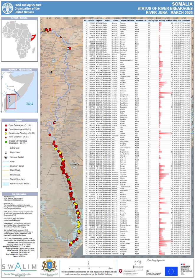
Status of river breakages along Juba and Shabelle rivers - issued March 2025
FAO-SWALIM has updated the status of the river breakages along the Juba and Shabelle Rivers using available Very High Resolution (VHR) satellite imagery and a Digital Elevation Model (DEM). Five types of breakages have been identified; Open, Overflow, Canal Breakage, Canal Intake Flooding and Closed with sandbags. The open breakages are those that are currently open as observed on the latest VHR image available. All the observations reported refers to the latest suitable VHR satellite image available, which is indicated in the online database. A legend/Key for further explanation of the different types of breakages is provided.
Along the Juba river 109 Open points, 1 Canal Breakage, 20 Canal flooding points, 87 Overflow points and 1 point closed with sandbags have been identified. Along the Shabelle river, a total of 98 Open breakage points, 2 Canal Breakages, 56 Canal flooding points, 94 Overflow points and 5 points closed with sandbags have been identified.
Users are advised that the methodology is biased towards Remote Sensing (RS) interpretation with only limited “ground truthing” due to access constraints. Open breakages might have been omitted in some cases where satellite images may not have been very clear (e.g. heavy cloud cover) or were not available.
Publication Type:
Map
Publication Date:
Author:
Corporate Author:

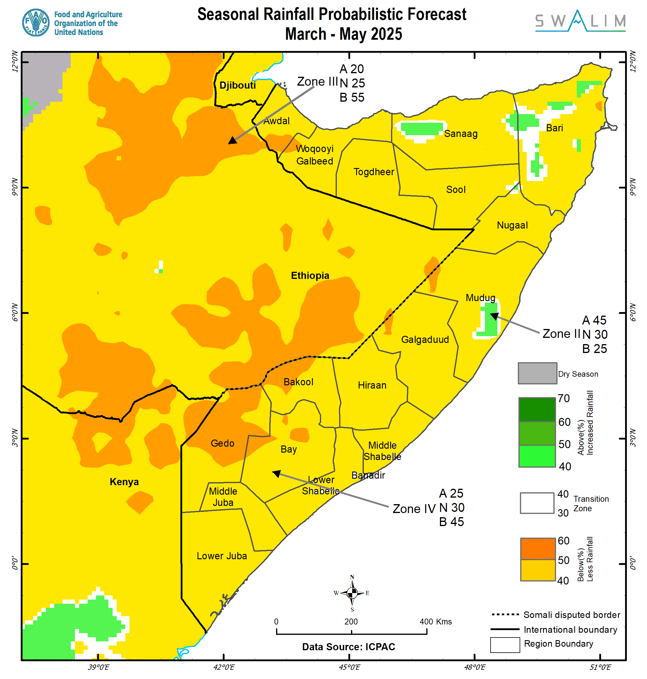
Gu 2025 Seasonal Climate Outlook and Action Plan for Somalia
The impacts of climate change have become more apparent in GHA’s cross-border regions, evident in the increased frequency and intensity of extreme weather and climate events, mainly recurring and severe droughts and floods. This national forum is, therefore, a much-needed platform that encourages exchange and interactions among pastoralists, farmers, climate information producers and users, and multi-institutional and multi-stakeholder collaboration. At the end of the workshop, the development and release of expected impacts and advisories based on the Gu 2025 seasonal outlook were the key outputs of the meeting.
The Gu season is crucial for all regions in Somalia, contributing up to 40-70% of annual rainfall in the southern and northwestern parts of the country, and 50-70% in the central and northern parts of the country. On average, the Gu season brings 200-300 mm of rainfall in the southern parts, 100-200 mm of rainfall over the central and northwestern parts, and 50-100 mm of rainfall over the northern parts of the country.
The Gu 2025 rainfall outlook shows a high likelihood of drier-than-normal conditions across all states and regions of Somalia, except for isolated highland areas in the Sanaag and Bari regions in the north and coastal parts of Hobyo district in Mudug region. Several areas in Gedo, Bakool and Galgaduud regions, northwestern parts of Bay region particularly Baydhaba district, eastern parts of Hiraan region, and areas of Mudug region bordering Ethiopia particularly Galdogob district, are predicted to have more than a 50 % likelihood of experiencing drier-than-normal conditions (Figure 1).
Publication Type:
Rainfall Outlook
Publication Date:
Author:
Corporate Author:

Somalia Rainfall Forecast – Issued 25 March 2025
This tail end of March marks the climatological start of the Gu rains with the arrival of the InterTropical Convergence Zone (ITCZ) from the southern hemisphere. Based on NOAA-NCEP Global Forecasting System (GFS), light rains are expected in the southern parts of the country with most parts of Somaliland and Puntland remaining dry. The status and forecast evolution of Madden Julian Oscillation (MJO) does not favor the likelihood of heavy rains within the forecast period.
The temporal and spatial distribution of the forecast rainfall (Map 1) are as follows:
Moderate cumulative rainfall of 50 mm and more is likely over very isolated areas in Dollow district, western parts of Luuq district and northern parts of Belet Xaawo district in Gedo region.
Light cumulative rainfall of less than 50 mm is forecast over most parts of Gedo region, and some parts of Lower Juba particularly Badhaadhe district, Bay particularly Baydhaba district, Bakool particularly Ceel Barde district, Hiraan particularly Belet Weyne town, Saakow district in Middle Juba region, Middle Shabelle including Banadir region. Light rainfall is also likely over the western parts of both Dhuusamareeb and Ceel Dheer districts in Galgaduud region, southmost parts of both Gebiley and Hargeisa districts in Woqooyi Galbeed region and elevated areas in eastern parts of Ceel Afweyn district in Sanaag region. It is important to point out that light to moderate rains is forecast to fall within the catchments of Juba River. Light rains are anticipated over the lower reaches of Shabelle River and moderate rains further up in Ethiopian Highlands.
Dry conditions are likely to prevail over vast areas in Mudug region, Nugaal region and Bari regions. Similarly dry conditions are also expected in Sool, most low-lying areas in Sanaag region, vast inland parts of Awdal region, Berbera district and northern parts of both Gebiley and Hargeisa districts in Woqooyi Galbeed region.
Publication Type:
Rainfall Forecast
Publication Date:
Author:
Corporate Author:
Review of Deyr 2024 Rainfall Performance, Jilal Status, Gu 2025 Outlook, and Implications on Livelihoods over Somalia
Contributing to about 60 % of annual rainfall, Gu season is critical for the Greater Horn of Africa (GHA) including Somalia. According to IGAD Climate Prediction and Application Centre (ICPAC), Gu 2025 is predicted to be characterized by below normal rainfall, normal to delayed onset and above normal temperatures. There is a 45 % likelihood that most parts of the country (Zone IV in yellow/orange in Map 4) will observe below normal rains. There is even a higher likelihood (55 %) of drier conditions being observed over Gedo, and some parts of Bay, Bakool, Hiraan and Awdal (dark orange). However, there are chances of very isolated above normal rains in some parts of Puntland. There is very low probability that cumulative Gu rainfall amount will exceed 200mm particularly over the Shabelle River Catchment. However, there are chances of exceedance over the uppermost and lowermost reaches of Juba River Catchment.
ICPAC have also reported that the status and predicted evolution of climate drivers in 2024/2025 closely resemble observations made in 2016/2017 and 2020/2021. The characteristics of the Gu 2025 are therefore expected to resemble those observed in 2017 and 2021.
Publication Type:
Rainfall Outlook
Publication Date:
Author:
Corporate Author:
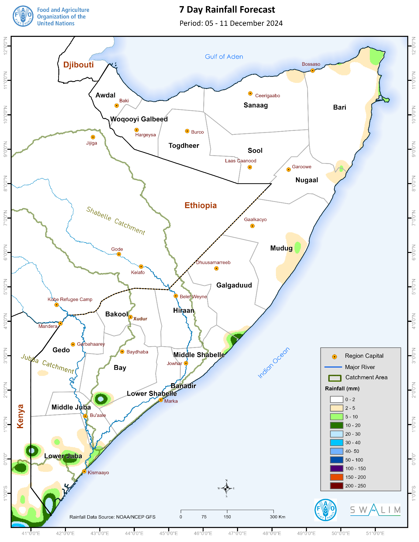
Somalia Rainfall Forecast – Issued 06 December 2024
According to NOAA-NCEP GFS, light rainfall is expected over isolated areas in Lower Juba and Bay and along the eastern coastal parts of the country with dry conditions likely to prevail elsewhere during the coming week (Map 3). As the Inter Tropical Convergence Zone (ITCZ) moves further south, the Northeast monsoon will develop further with strengthened wind conditions particularly at Eyl district in Nugaal region and Bandarbeyla district in Bari region. The light rains along the narrow upper eastern coastal areas are therefore likely to be favoured by the moisture influx associated with these winds. However, the present and forecast forward propagation of the Madden Julian Oscillation (MJO) index is likely to suppress moisture availability with very low chance of significant rainfall in the next 2 weeks.
The temporal and spatial distribution of the forecast rainfall (Map 3) are as follows:
Light cumulative rainfall of less than 50 mm is forecast over isolated areas in Lower Juba region and in Dinsoor district in Bay region. Similar rains are likely over a narrow strip along the eastern coastal parts of the country particularly at the following areas: Adan Yabaal district in Middle Shabelle region, Ceel Dheer district in Galgaduud region, Hobyo district in Mudug region, Eyl district in Nugaal region, and Bandarbeyle and Caluula district in Bari region.
Dry conditions are likely to prevail over the rest of the country particularly Gedo, Bakool, Lower Shabelle, Hiraan, Sool, Sanaag, Togdheer, Woqooyi Galbeed and Awdal regions and inland areas of the following regions: Middle Shabelle, Galgaduud, Mudug, Nugaal and Bari.
Publication Type:
Rainfall Forecast
Publication Date:
Author:
Corporate Author:
Pages
 RSS feed [compliant with the Agris AP] |
  Agris AP XML