Library Catalog
Latest Documents and Publications listed. Use search terms in the box below to find what you need
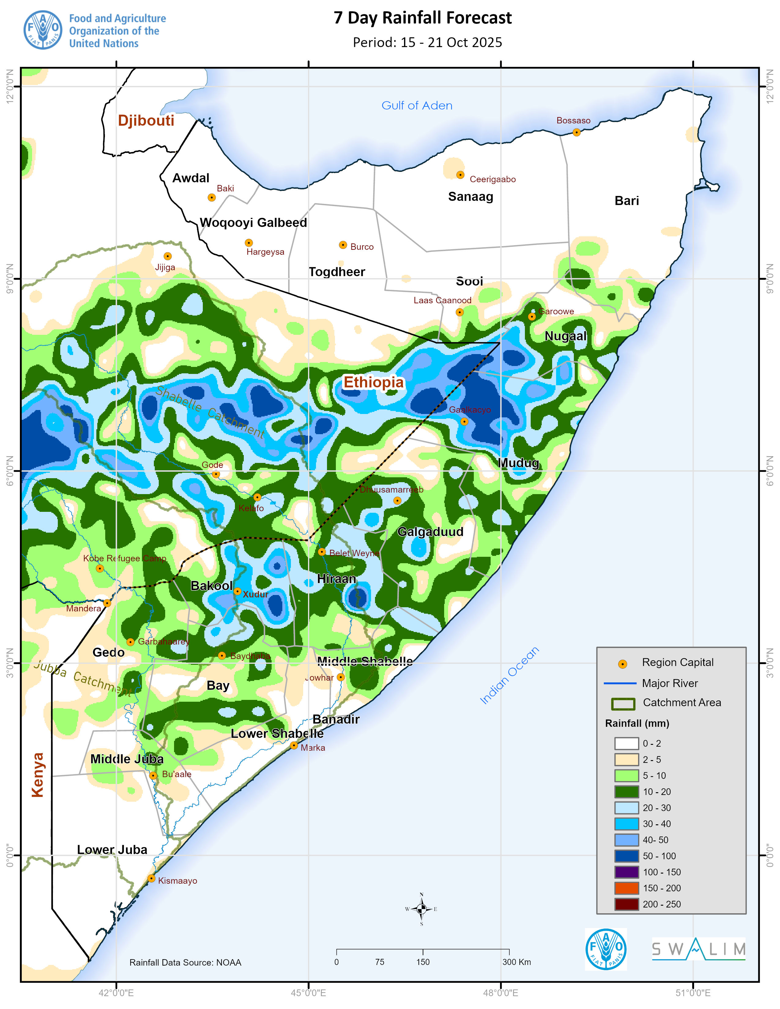
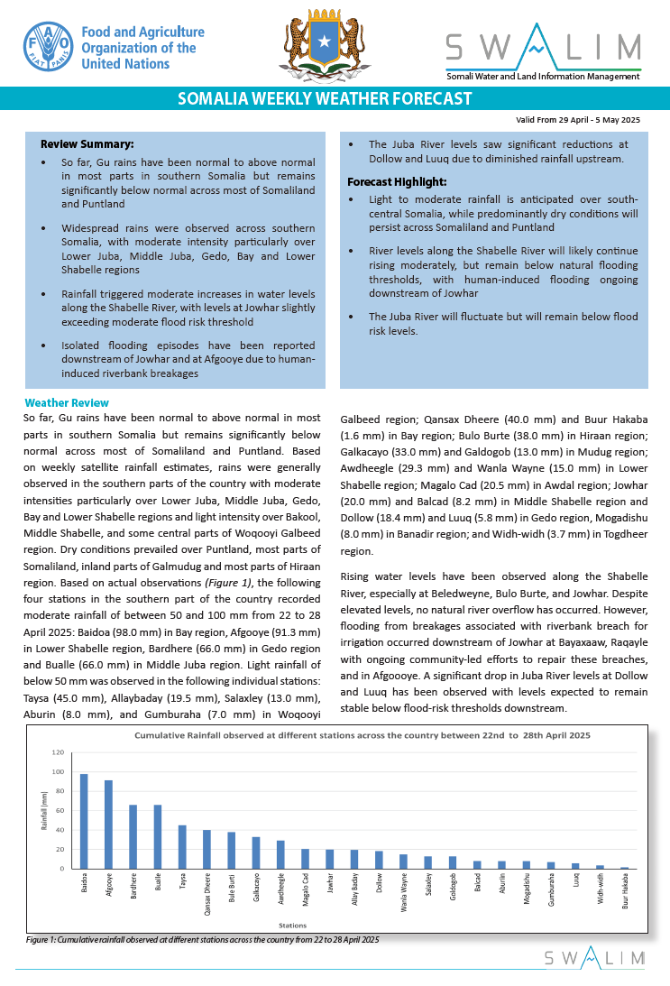
Somalia Rainfall Forecast – Issued 15 October 2025
According to NOAA-NCEP GFS, widespread light to moderate rainfall is expected over most parts of central Somalia including Nugaal, Mudug, Galgaduud, Hiraan, Middel Shabelle, Bay and Bakool regions. The north and southmost parts of the country are expected to remain dry. The spatial spread of the forecast rainfall conditions are as follows (Figure 1):
Moderate rainfall of between 50.0 and 100.0 mm is forecast over most parts of Galkacyo district in Mudug, central parts of Burtinle district in Nugaal, central parts of Tayeeglow district in Bakool and central parts of Bulo Burte district in Hiraan region which forms the middle section of the Shabelle River in Somalia. Rains of similar moderate intensity are also likely over the uppermost catchment of Shabelle River in Ethiopia.
Light rainfall of less than 50.0 mm is expected over most other parts of Mudug, Nugaal, Bakool and Hiraan regions. Rains of lighter intensity are also likely over most parts of Galgaduud, Middle Shabelle, and Bay regions, Luuq district in Gedo region, Bu’aale district in Middel Juba region, southern parts of Qardo and Bandarveyla districts in Bari region. Similar light rains are expected over the middle and upper sections of the Juba River catchment and over upper portions of Shabelle River catchment within Somalia.
Dry conditions are likely over most parts of Somaliland including Awdal, Woqooyi Galbeed, Togdheer, Sool and Sanaag regions; most parts of Bari, Lower Juba, Middle Juba, and Lower Shabelle regions. Dry conditions are also likely to prevail over most parts of Garowe district in Nugaal region; Cadaado and Cabudwaaq districts and eastern parts of Ceel Buur district in Galgaduud; Jilib abd Saakow districts in Middle Juba region; Baardheere, Ceel Waaq, Garbahaarey, Belet Xaawo and Dollow districts in Gedo region;and coastal parts of Middle Shabelle including Banadir. Similar dry conditions are likely over most areas over the lower sections of the Juba River catchment within Somalia.
Publication Type:
Rainfall Forecast
Publication Date:
Author:
Corporate Author:
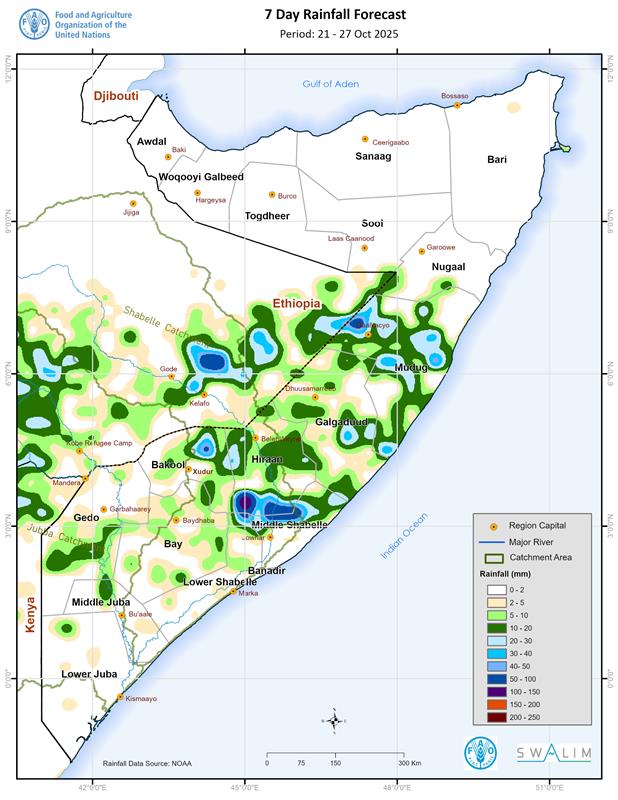
Somalia Rainfall Forecast – Issued 22 October 2025
According to NOAA-NCEP GFS, rainfall is expected over some parts of central Somalia with moderate intensity in parts of Hiraan, Middle Shabelle and Mudug regions. The north and southmost parts of the country are expected to remain dry. The spatial spread of the forecast rainfall conditions is as follows (Figure 1):
Heavy rainfall of above 100 mm is likely over western parts of Bulo Burte district in Hiraan region.
Moderate rainfall of between 50 and 100 mm is forecast over Jalalaqsi district in Hiraan region; northern parts of both Jowhar and Cadale districts in Middle Shabelle region; northern parts of Wanla Weyn district in Lower Shabelle region; Galdogob and western parts of Galkacyo district in Mudug region; and northeastern border areas of Xudur district with Ceel Barde district in Bakool region. The middle sections of the Shabelle River catchment within Somalia and its upper catchments in Ethiopia is also likely to observe rains of moderate amounts.
Light rainfall of less than 50 mm is expected over most parts of Belet Weyne district in Hiraan region; Galkacyo, Hobyo and Xaradheere districts in Mudug region; Ceel Buur district in Galgaduud region; Adan Yabaal district in Middel Shabelle region; Wanla Weyn district in Lower Shabelle region; northern parts of Xudur district, eastern parts of Ceel Barde district and northern parts of Tayeeglow district in Bakool region; Ceel Waaq district and northern parts of Baardheere district in Gedo region and some localized parts of Bay region. Rainfall of lighter intensity is likely to be observed in areas adjacent to the above districts and regions including the middle sections of the Juba River catchment within Somalia and upper catchments outside the country. Most parts of the Shabelle River catchment in the Somalia-Ethiopia border are likely to receive similarly light rains.
Dry conditions are likely over most parts of Somaliland including Awdal, Woqooyi Galbeed, Togdheer, Sool and Sanaag regions; Bari, Nugaal, Lower Juba, Middle Juba, Bay and Banadir regions; Belet Xaawo, Dollow and Luuq districts in Gedo region; Rab Dhuure and Waajid districts and southern parts of Xudur district in Bakool region; Sablaale, Baraawe, Kurtunwaarey, Qoryooley, Marka and Afgooye districts in Lower Shabelle region; Balcad district in Middle Shabelle region; central parts both Ceel Dheer and Ceel Buur districts and eastern parts of Dhuusamarreeb district in Galgaduud region; and Jariiban district in Mudug region. Similar dry conditions are likely over most areas in the lower sections of the Juba River catchment within Somalia.
Publication Type:
Rainfall Forecast
Publication Date:
Author:
Corporate Author:
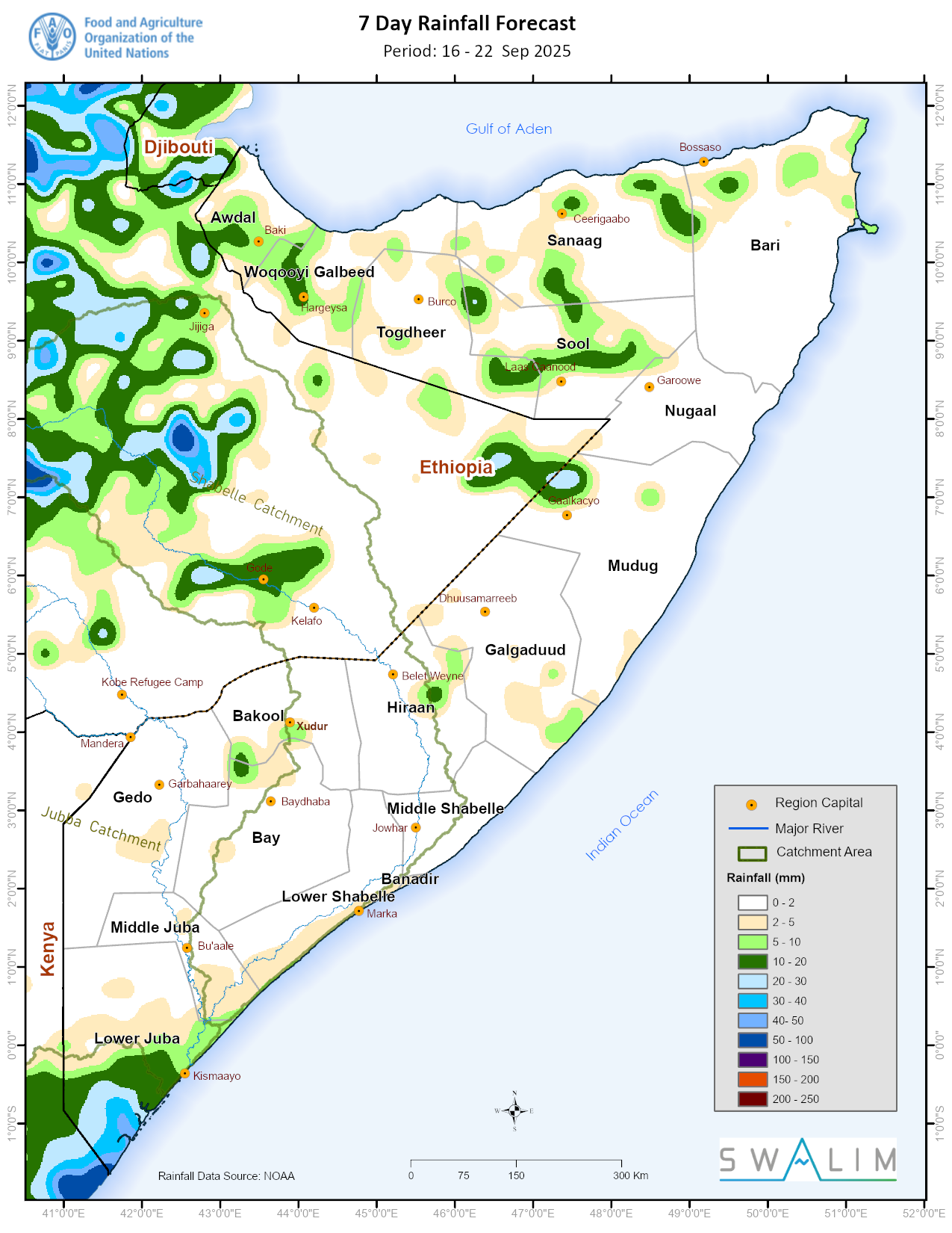
Shabelle riverine flood advisory and Badhaadhe flash flood advisory - Issued 17 September 2025
The Shabelle River at Jowhar has risen sharply, reaching 5.40 m, only 10 cm below the bank-full level of 5.50 m. This occurred despite dry conditions over the entire Somali and Ethiopian catchment. No natural overbank flow has been recorded yet, and upstream stations at Belet Weyne and Bulo Burte remain below flood-risk levels. The cause of this isolated sharp rise is still under investigation.
Forecasts from NOAA-GFS indicate a westward-moving weather system that is likely to bring very intense rainfall on Monday, 22 September 2025 over Badhaadhe District. Light rains are expected in Kismaayo District (Lower Juba), Awdal Region (Somaliland), Laasqoray District (Sanaag), and northern Bari, with dry conditions elsewhere
Publication Type:
Flood Alert
Publication Date:
Author:
Corporate Author:
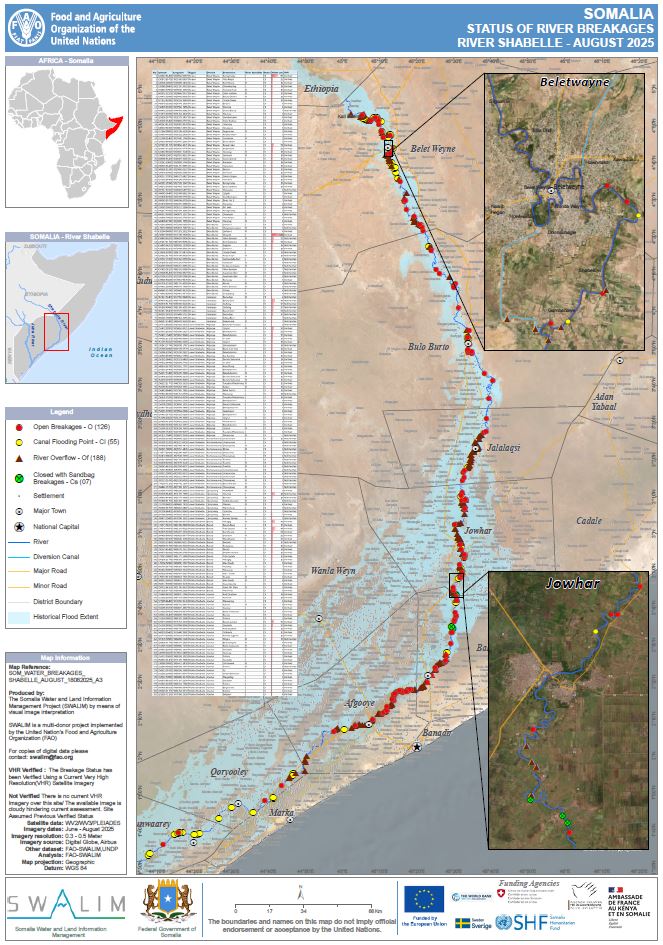
Status of river breakages along Juba and Shabelle rivers - issued August 2025
FAO-SWALIM has updated the status of the river breakages along the Juba and Shabelle Rivers using available Very High Resolution (VHR) satellite imagery and a Digital Elevation Model (DEM). Five types of breakages have been identified; Open, Overflow, Canal Breakage, Canal Intake Flooding and Closed with sandbags. The open breakages are those that are currently open as observed on the latest VHR image available. All the observations reported refers to the latest suitable VHR satellite image available, which is indicated in the online database. A legend/Key for further explanation of the different types of breakages is provided.
Along the Juba River, 105 open breakages, 14 canal flooding points, 31 river overflow and 2 points closed with sandbags were identified. While along the the Shabelle River 126 open breakages, 55 canal flooding points, 188 river overflow and 7 places closed with sandbags were identified. Users are advised that the methodology is biased towards Remote Sensing (RS) interpretation with only limited “ground truthing” due to access constraints. Open breakages might have been omitted in some cases where satellite images may not have been very clear (e.g. heavy cloud cover) or were not available.
Publication Type:
Map
Publication Date:
Author:
Corporate Author:

Somalia Gu 2025 Rainfall Performance Review Hagaa Outlook and Impacts on Livelihoods
According to the seasonal Outlook co-produced by FAO SWALIM, World Meteorological Organization (WMO), IGAD Climate Prediction and Application Centre (ICPA)C, and Government of Somalia, Gu 2025 was expected to be characterized by below normal rainfall, normal to delayed onset and above normal temperatures. There was a 45 % likelihood that most parts of the country were to observe below normal rains. There was even a higher likelihood (55 %) of drier conditions being observed over Gedo region, and some parts of Bay, Bakool, Hiraan and Awdal regions. However, there were chances of very isolated above normal rains in some parts of Puntland. There was a very low probability that cumulative Gu rainfall amount would exceed 200mm particularly over the Shabelle River Catchment. However, there were chances of an exceedance of 200 mm over the Juba River Catchment (Middle Juba and Lower Juba).
Publication Type:
Rainfall Performance
Publication Date:
Author:
Corporate Author:
Somalia Rainfall Forecast – Issued 07 May 2025
Light to moderate rains is expected across central and southern regions this week, with intense storms possible in Middle Shabelle and Galgaduud. Dry and hot conditions persist in Puntland and Awdal, raising heat stress and water scarcity concerns. Rainfall prospects remain favorable for most of May.
Publication Type:
Rainfall Forecast
Publication Date:
Author:
Corporate Author:

Somalia Rainfall Forecast – Issued 13 May 2025
According to the NOAA-NCEP Global Forecasting System (GFS) forecast, sparse light rains are expected across the country with chances of moderate intensity over Lower Juba, Hiraan and Mudug. Dry conditions are generally likely over most parts of Puntland and Somaliland. The temporal and spatial distribution of the forecast rainfall are as follows:
Light cumulative rainfall of less than 50 mm is forecast over most parts of Banadir region; Middle Juba region particularly Jilib and Bu’aale districts; Lower Shabelle region particularly Baraawe and Marka districts; eastern parts of Ceel Waaq district in Gedo region; Qansax Dheere, central parts of Diinsoor distirct, northern parts of Buur Hakaba district and Baydhaba town in Bay region; Xudur district in Bakool region; areas bordering both Belet Wayne and Bulo Burte districts; Galagaduud region particularly Dhuursamarreeb district, western parts of Ceel Buur and north-eastern pats of Ceel Dheer districts; eastern parts of Hobyo districts in Mudug region; Togdheer region particularly Buuhodle district, western parts of Owdweyne district and northern parts of Burco district; northern parts of Caynabo district in Sool region; and Sanaag region particularly Ceerigaabo district.
Dry conditions are likely to prevail over most parts of Awdal, Woqooyi Galbeed, Nugaal, Bari and Middle Shabelle regions; Togdheer region particularly Sheikh and northern parts of Owdweyne district; Sanaag region particularly Ceel Afweyn, Laasqoray and southern parts of Ceerigaabo district; Xudun and Taleex districts in Sool region; most parts of Galdogob, Gaalkacyo, Jariiban and western parts of Hobyo district in Mudug region; Galgaduud region particularly Cabudwaaq, eastern parts of Ceel Dheer and Ceel Buur districts; Hiraan region particularly Jalalaqsi district; northern parts of Baydhaba district in Bay region; Saakow district in Middle Juba region; Gedo region particularly Doolow, Luuq, Baardheere and southern parts of Belet Xaawo district; and Afmadow district in Lower Juba region.
Publication Type:
Rainfall Forecast
Publication Date:
Author:
Corporate Author:
Somalia Rainfall Forecast – Issued 20 May 2025
Based on NOAA-NCEP Global Forecasting System (GFS), scanty rains are expected over some parts of the country with moderate rains expected in Sool region and areas at the border of Mudug and Nugaal regions. Dry conditions are likely to prevail over most parts of the Somaliland and south-central.
Light cumulative rainfall of less than 50 mm is forecast over most parts of Banadir region; Badhaadhe, Kismaayo and Jamaame districts in Lower Juba region; Lower Shabelle region particularly coastal parts from Baraawe, Marka and Afgooye districts; several parts of Baydhaba town and north-western parts of Buur Hakaba districts in Bay region; most parts of Xudun,Taleex, southern parts of Caynabo and northern parts of Laas Caanood districts in Sool region; central parts of Jariiban district and north-eastern parts of Gaalkacyo districts in Mudug region; central parts of Nugaal region particularly areas bordering Eyl, Garoowe and Burtinle districts; and Bari region particularly central parts of Bandarbeyla district and eastern parts of Iskushuban district.
Dry conditions are likely to prevail over most parts of Awdal, Woooyi Galbeed,Togdheer,Sanaag, Galgaduud, Hiraan, Bakool, Middle Juba, Gedo, and Middle Shabelle regions; most parts of Xarardheere, Hobyo, Galdogob, and sothern parts of Gaalkacyo districts in Mudug region;most parts of Diinsoor, Qansax Dheere, southern parts of Buur Hakaba and northern parts of Baydhaba districts in Bay region; most parts of Lower Shabelle region particularly Sablaale, Kurtunwaarey, Qoryooley, Afgooye and Wanla Weyn districts; isolated areas of Garoowe,Eyl,and Jariiban districts and northern areas of Burtinle district in Nugaal region; most parts of Qardho, Calluula, Qandala, Bossaso, southern parts of Bandarbeyla and eastern parts of Iskusuban districts in Bari region and several parts Afmadow district in Lower Juba region.
Publication Type:
Rainfall Forecast
Publication Date:
Author:
Corporate Author:

Somalia Strong Wind Advisory – Issued 23 May 2025
Forecasts from NOAA GFS indicate a strong surge in southeasterly to easterly winds along the Somali coastline, beginning Friday 23 May and persisting through Sunday 26 May. Wind speeds are expected to exceed 25 knots (12.9 m/s) over coastal waters, with localized intensification to >30 knots (15.4 m/s) especially offshore of Lower Juba, Middle Juba, Lower Shabelle, and Banadir. Strong onshore winds may also affect Hobyo (Mudug), Eyl (Nugaal), and Bosaso (Bari). These winds may induce coastal waves exceeding 2 metres, particularly along the Indian Ocean coast between Kismayo and Hobyo, creating rough marine conditions.
Publication Type:
Storm Alert
Publication Date:
Author:
Corporate Author:

Somalia Rainfall Forecast – Issued 27 May 2025
According to NOAA-NCEP Global Forecasting System (GFS), light rains are expected over some parts of Bari, Sool and Sanaag regions and the coastal parts of Lower Juba, Middel Juba, Lower Shabelle and Banadir regions. Dry conditions are likely to prevail over the rest of the country.
The temporal and spatial distribution of the forecast rainfall (Figure 1) are as follows:
Light cumulative rainfall of less than 50 mm is forecast over most parts of Banadir region; Jamaame district, and coastal parts of both Badhaadhe and Kismaayo districts in Lower Juba region, Bu’aale and Jilib districts in Middle Juba region; Baraawe ,Marka, Sablaale,Kurtunwarrey, Qoryooley and Afgooye districts in Lower Shabelle region; several parts Jowhar and Balcad districts in Middle Shabelle region; Diinsoor and Buur Hakaba district and southern parts of Baydhaba district in Bay region; northern parts of Qardho district, northern areas of both Bandarbeyla and Iskushuban districts in Bari region; border areas of Ceel Afweyn and Ceerigaabo districts and southern parts of Laasqoray in Sanaag region; north-eastern parts of Burco district and northern parts of Buhoodle district in Togdheer region; most parts of Xudun and Taleex districts, north-eastern parts of Caynabo district and Laas Caanood town in Sool region; and its border areas with Burtinle district in Nugaal region.
Dry conditions are likely to prevail over the rest of the country particularly Awdal, Woqooyi Galbeed, Nugaal, Mudug, Galgaduud, Hiraan, Bakool, and Gedo regions. Dry conditions are also likely over most parts of Togdheer region particularly Sheikh and Owdweyne districts, south and north-western parts of Burco district and southern parts of Buuhoodle district; Ceel Afweyn and Ceerigaabo districts and northern parts of Laasqoray district in Sanaag region; Bossaso, Qandala and Caluula districts, southern parts of Bandarbeyla district and central parts of Iskushuban district in Bari region; northern parts of Caynabo district and eastern parts of Laas Caanood district in Sool region; most parts of Afmadow district and inland areas of both Baadhadhe and Kismayo districts in Lower Juba region; Saakow district in Middle Juba region; most parts of Qansax Dheere district and north-western parts of Baydhaba district in Bay region; Wanla Weyn district in Lower Shabelle region; and several parts of Cadale and Adan Yabaal districts in Middle Shabelle region.
Publication Type:
Rainfall Forecast
Publication Date:
Author:
Corporate Author:
Pages
 RSS feed [compliant with the Agris AP] |
  Agris AP XML