Library Catalog
Latest Documents and Publications listed. Use search terms in the box below to find what you need
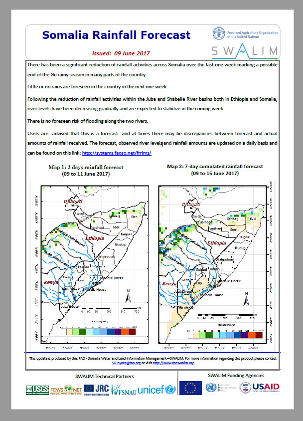
Somalia Rainfall Forecast 09-06-2017
There has been a significant reduction of rainfall activities across Somalia over the last one week marking a possible end of the Gu rainy season in many parts of the country.
Little or no rains are foreseen in the country in the next one week.
Following the reduction of rainfall activities within the Juba and Shabelle River basins both in Ethiopia and Somalia, river levels have been decreasing gradually and are expected to stabilize in the coming week.
There is no foreseen risk of flooding along the two rivers.
Publication Type:
Rainfall Forecast
Publication Date:
Author:
Corporate Author:

Gu 2017 Rainfall Performance Bulletin
Somalia is in the second year of a severe drought the kind that is increasingly likely as the climate warms. Somali communities were looking forward to a relief from the Gu 2017 rainfall season but the devastating drought conditions meant that the country experienced yet another below-average season affecting the recovery of the key livelihood sectors; agricultural and livestock. So far, drought conditions continues to affect Somalia; a situation that may persist until the next rainy season in October.
The Gu rainy season was generally poor in most parts of the country except some places in Puntland and Somaliland that saw good rains during the month of May. The southern regions of Middle Juba, Lower Juba and southern Bay also recorded good rains during the months of May and June. Regions that recorded very poor rains include Mududg, Galgaduud, Hiraan, Middle Shabelle, Lower Shabelle, Bakool, Gedo and southern parts of Bay (Map 1).
The Gu rains were sporadic and scattered. In March, a few pockets of Somaliland recorded good rains followed by a long dry period until end of April when the rains started in most parts albeit very late. The rains then spread in space, time and quantity in May. While many parts continued to receive rains until the last week of May, there was an early cessation of the rains in many parts of south and central regions except South of Bay and Middle and Lower Juba regions that continued to receive rains in June.
Even with the rains, most parts of the country remain under drought conditions with the impacts being felt across the country. More rains are required to end the ongoing drought in the country and the drought situation is expected to continue until the coming Deyr season in October.
It is important to note that only 20% to 40% of the ground water sources have been sufficiently recharged throughout the country. The rest remain water stressed.
The rains, though poorly distributed, eased stress levels for the livestock sector due to regrowth of pasture, which provided grazing lands. Areas with below normal rains also saw regrowth of pasture, but may not last until the next season expected in October.
If El Niño predictions for late 2017 prove correct, Deyr rainfall in Somalia could be substantial. Most climate models gives the El Niño event a 45 percent chance of returning in 2017. El Niño events tends to cause enhanced rainfall events in Somalia, generally cool temperatures and lots of run-off, which would be good for both ground and surface water recharge in the country.
Publication Type:
Rainfall Performance
Publication Date:
Author:
Corporate Author:

Saadaasha Roob-da’idda Soomaaliya 09-05-2017
Labadii maalmood oo u dambeeyey ayaa waxaa sii socday roobab fudud ilaa kuwo dhexdhexaad ah oo ka da’ay dhawr meelood oo dalka ku kala yaal. Roobabka waxaa la filayaa in ay toddobada maalin ee na soo xiga ka sii socdaan gudaha qaybo badan oo dalka ka tirsan. Saadaasha roob da’idda ee toddobaadka soo aadan (Khariirad 2), waxay muujineysaa in roobab dhexdhexaad ah ilaa kuwo culus ay ka jiri doona gudaha Soomaaliland iyo Puntland.
Waxaa gudaha qaybaha koonfureed laga filayaa roobab fudud ilaa kuwo dhexdhexaad ah halka gobollada dhexe la filayo in ay isla muddadaas ahaadaan qalayl. Buuraleyda sare Itoobiya ayaa sidoo kale iyagana la filayaa inay sii ka socdaan roobabka da’aya isla muddadaas inta lagu jiro. Tani ayaa markeeda horseedi doonta inay sii kordhaan heerarka biyaha gudaha webiyada Juba iyo Shabeelle. Fatahaado webi ayaa laga soo sheegay aagga bartamaha webi Shabeelle taas oo ay ugu wacan tahay dacallo furan iyo gebiyada oo tag daran. Weli waxaa halkaas ka jira halis fatahaad dhexdhexaad ah qaybaha dhexe iyo xagga hoose ee webiga Shabeelle. Ma jirto wax halis fatahaad ah oo laga filayo jiidda webi Juba.
Isticmaaleyaash xogtaan waxaa loo sheegayaa inay waxaani yihiin saadaal oo ay dhici karto in mararka qaar ay wax isweydaartaan saadaasha iyo xaqiiqda qadarka roobka la helay.
Publication Type:
Rainfall Forecast
Publication Date:
Author:
Corporate Author:

Somalia Rainfall Forecast 02-05-2017
Rainfall activities intensified in many parts of the country over the last three days. Flash floods were reported in some places including Bari, Nugaal, Mudug and Bay regions following the heavy rains. Most stations in these regions recorded over 50mm in the three days with Baidao station recording 100mm on 30 April 2017.
The rains are expected to continue in most parts of the country in the next seven days but with less magnitude. The Ethiopian highlands are also expected to continue receiving rains during the same period. This is will turn lead to increased river levels along the Juba and Shabelle Rivers. There is no risk of flooding along the rivers during the forecast period.
Users are advised that this is a forecast and at times there may be discrepancies between forecast and actual amounts of rainfall received.
Publication Type:
Rainfall Forecast
Publication Date:
Author:
Corporate Author:
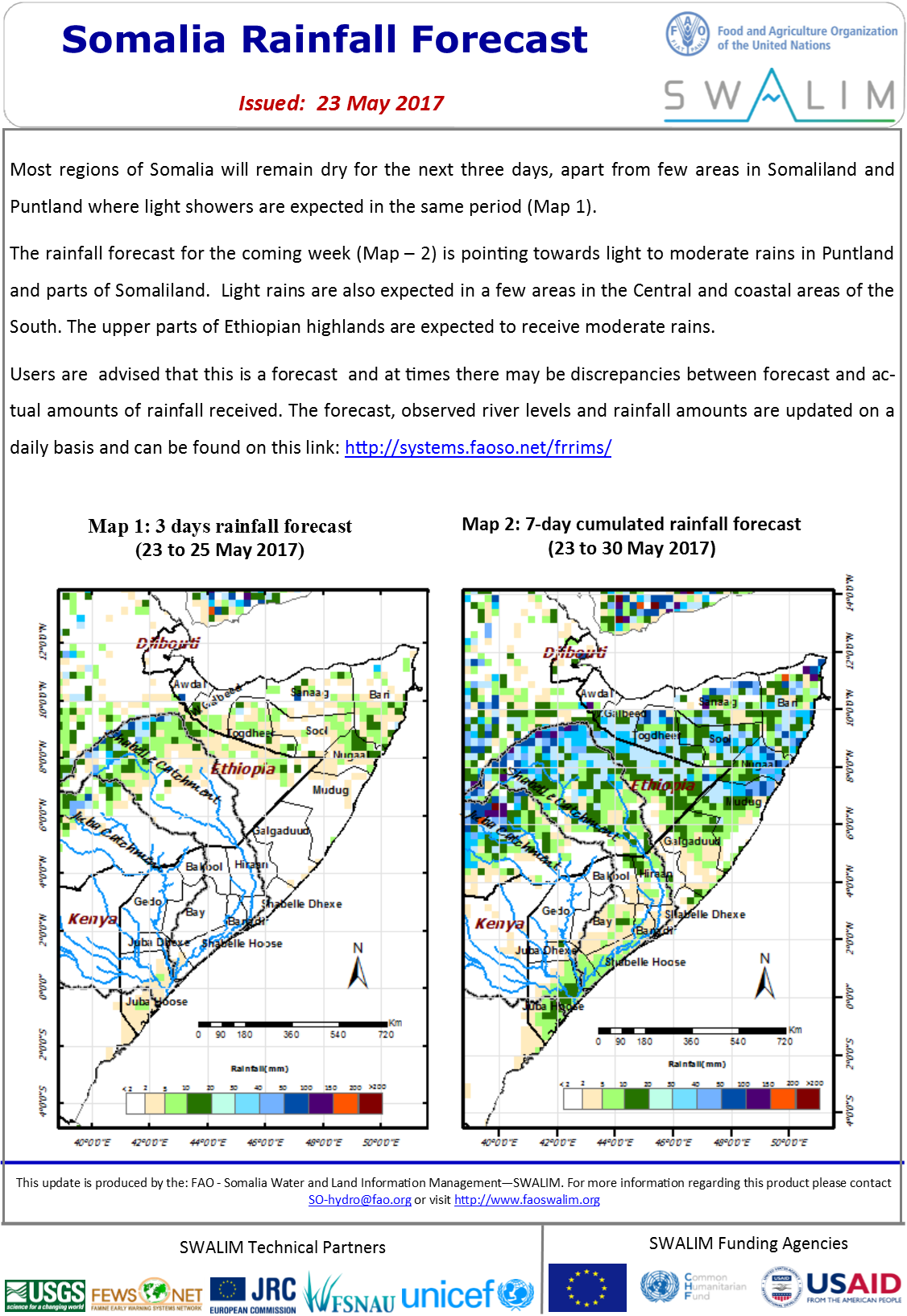
Somalia Rainfall Forecast 23-05-2017
Most regions of Somalia will remain dry for the next three days, apart from few areas in Somaliland and Puntland where light showers are expected in the same period.
The rainfall forecast for the coming week is pointing towards light to moderate rains in Puntland and parts of Somaliland. Light rains are also expected in a few areas in the Central and coastal areas of the South. The upper parts of Ethiopian highlands are expected to receive moderate rains.
Users are advised that this is a forecast and at times there may be discrepancies between forecast and actual amounts of rainfall received.
Publication Type:
Rainfall Outlook
Publication Date:
Author:
Corporate Author:
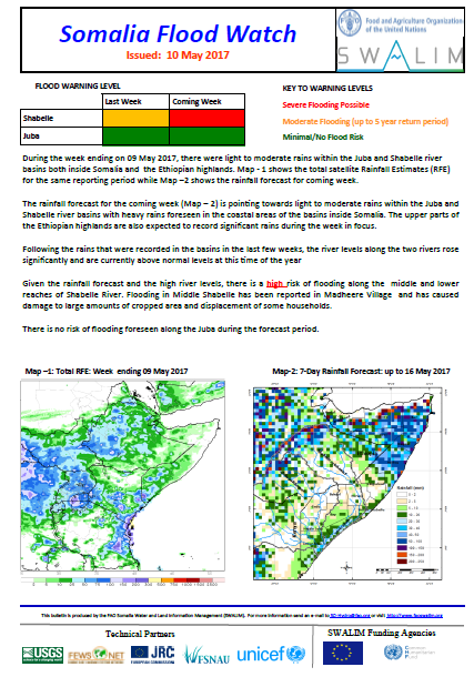
Somalia Flood Watch Bulletin 10-05-2017
During the week ending on 09 May 2017, there were light to moderate rains within the Juba and Shabelle river basins both inside Somalia and the Ethiopian highlands.
The rainfall forecast for the coming week is pointing towards light to moderate rains within the Juba and Shabelle river basins with heavy rains foreseen in the coastal areas of the basins inside Somalia. The upper parts of the Ethiopian highlands are also expected to record significant rains during the week in focus.
Following the rains that were recorded in the basins in the last few weeks, the river levels along the two rivers rose significantly and are currently above normal levels at this time of the year. Given the rainfall forecast and the high river levels, there is a high risk of flooding along the middle and lower reaches of Shabelle River. Flooding in Middle Shabelle has been reported in Madheere Village and has caused damage to large amounts of cropped area and displacement of some households. There is no risk of flooding foreseen along the Juba during the forecast period.
Publication Type:
Flood watch bulletin
Publication Date:
Author:
Corporate Author:
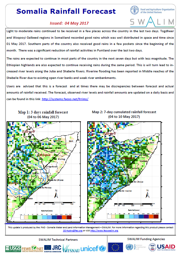
Somalia Rainfall Forecast 04-05-2017
Light to moderate rains continued to be received in a few places across the country in the last two days. Togdheer and Woqooyi Galbeed regions in Somaliland recorded good rains which was well distributed in space and time since 01 May 2017. Southern parts of the country also received good rains in a few pockets since the beginning of the month. There was a significant reduction of rainfall activities in Puntland over the last two days.
The rains are expected to continue in most parts of the country in the next seven days but with less magnitude. The Ethiopian highlands are also expected to continue receiving rains during the same period. This is will turn lead to increased river levels along the Juba and Shabelle Rivers. Riverine flooding has been reported in Middle reaches of the Shabelle River due to existing open river banks and weak river embankments.
Users are advised that this is a forecast and at times there may be discrepancies between forecast and actual amounts of rainfall received.
Publication Type:
Rainfall Forecast
Publication Date:
Author:
Corporate Author:
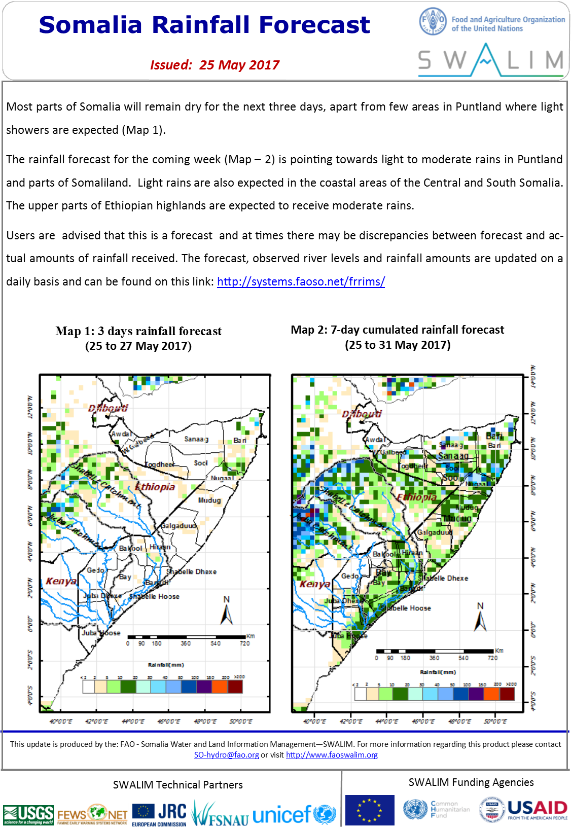
Somalia Rainfall Forecast 25-05-2017
Most parts of Somalia will remain dry for the next three days, apart from few areas in Puntland where light showers are expected.
The rainfall forecast for the coming week is pointing towards light to moderate rains in Puntland and parts of Somaliland. Light rains are also expected in the coastal areas of the Central and South Somalia. The upper parts of Ethiopian highlands are expected to receive moderate rains.
Publication Type:
Rainfall Forecast
Publication Date:
Author:
Corporate Author:
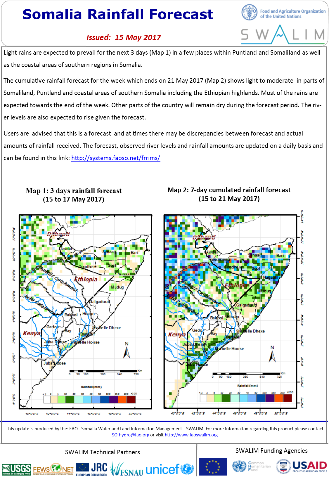
Somalia Rainfall Forecast 15-05-2017
Light rains are expected to prevail for the next 3 days (Map 1) in a few places within Puntland and Somaliland as well as the coastal areas of southern regions in Somalia.
The cumulative rainfall forecast for the week which ends on 21 May 2017 (Map 2) shows light to moderate in parts of Somaliland, Puntland and coastal areas of southern Somalia including the Ethiopian highlands. Most of the rains are expected towards the end of the week. Other parts of the country will remain dry during the forecast period. The river levels are also expected to rise given the forecast.
Publication Type:
Rainfall Forecast
Publication Date:
Author:
Corporate Author:
Saadaasha Roob-da’idda Soomaaliya 04-05-2017
Labadii maalmood ee laga soo gudbay roobab fudfudud ilaa kuwo dhexdhexaad ah ayaa ka sii socoday gudaha dhawr meelood oo ka yaal dalka oo dhan.Gudaha Gobollada Togdheer iyo Waqooyi Galbeed ee gudaha Somaalilan waxaa la diiwaangeliyey roobab fiicfiican kuwaas oo si habbon ugu qaybsanaa dhul iyo waqti ahaanba tan iyo 1-dii May 2017. Qaybaha koonfureed ee dalka sidoo kale waxay heleen roobab fiicfiican gudaha dharw meelood oo kooban tan iyo bilowgii bishaan May. Marka la eego labadii maalmood eedhanbe waxaa jirey gudaha Puntland hoos-u-dhac waxkuool ah ee roobabkii da’ayey.
Roobabka waxaa la filayaa in ay ka sii socdaan gudaha dalka intiisa badan labada maalmood ee soo socota, laakiin hab si hooseysa ah. Buuraleyda saree e Itoobiya waxaa sidoo kale la filayaa inuu sii socdo helitaanka roobabka isla muddada tan. Arrintaani marka waxay horseedeysaa in heerar webiyada Juba iyo Shabeelle ay kordhaan. Fataad webiyeed ayaa laga soo sheegay Gobolka Bartamaha webiga Shabeelle iyadoo ay ugu wacan tahay daamanka oo furan iyo gebiyada webiga tag daran.
Qolyaha isticmaalaya xogtaan waxaa lagu wargelinaya in waxaani ay tahay saadaal oo mararka qaar waxaa ka jiri kara farqi ka duwanaan oo ka dhex dhaca saadaasha iyo qadarka xaqiiqda roob la helay.
Saadaasha, heerarka webiga la arkay iyo qadaka roobka-da’a waxaa loo cusboonaynsiiyaa si maalinle ah waxaana laga helikaraa gudaha xiriirkaan: http://systems.faoso.net/frrims/
Publication Type:
Rainfall Forecast
Publication Date:
Author:
Corporate Author:
Pages
 RSS feed [compliant with the Agris AP] |
  Agris AP XML