Library Catalog
Latest Documents and Publications listed. Use search terms in the box below to find what you need
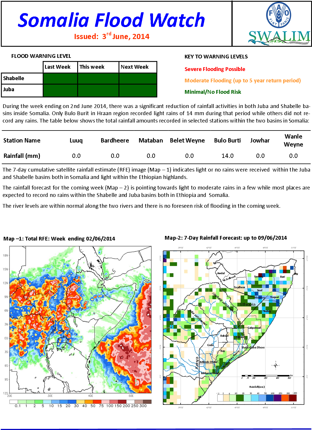
Flood Watch Bulletin 20-05-2014
There was a slight decrease of rainfall activities in most parts of the Juba and Shabelle river basins inside Somalia. A few places recorded moderate rains while others did not receive any rains during the last one week.
Publication Type:
Flood watch bulletin
Publication Date:
Author:
Corporate Author:
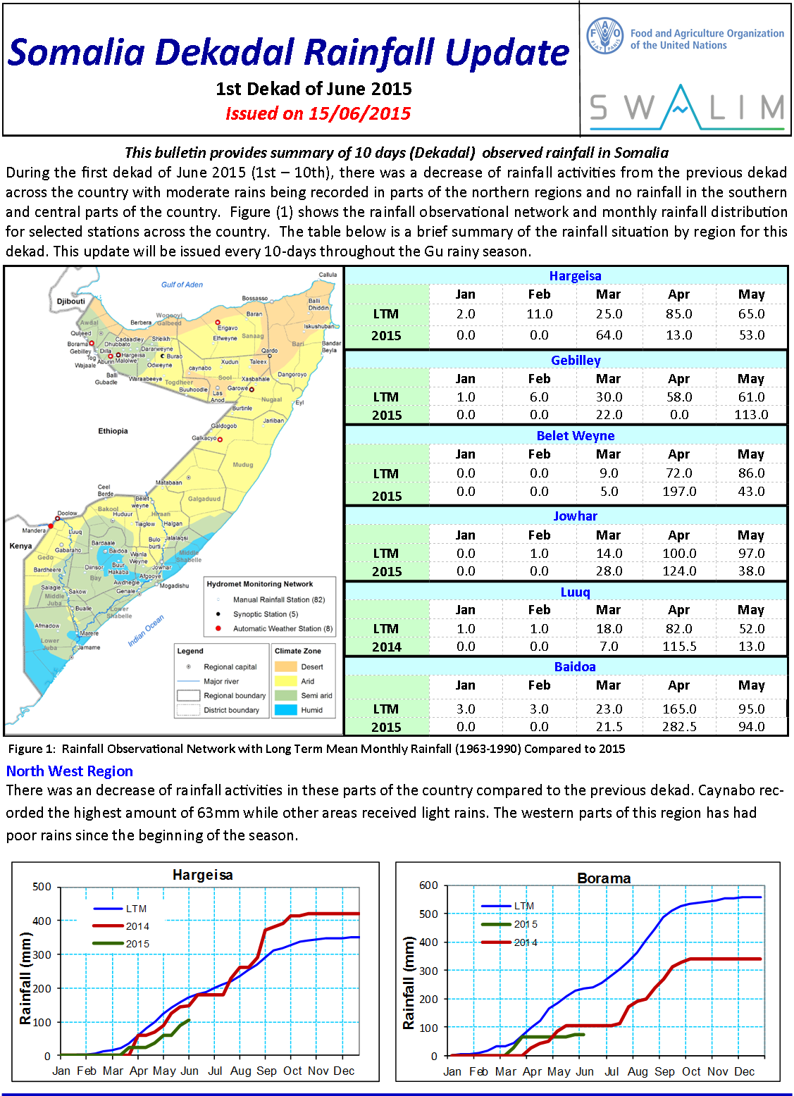
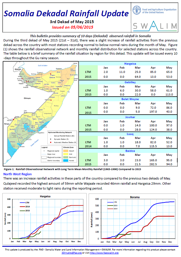
Somalia Dekadal Rainfall Bulletin - Dekad 12 2014
During the 12th Dekad (21st – 30th April 2014), moderate to heavy rains were recorded in the southern parts of the country especially in bay and Bakool regions. Light rains were received in the north western parts of the country. The north eastern and central parts did not receive any significant rainfall during the period. In general the rainfall performance of April rains in the country was below normal with the North East and central parts experiencing extremely depressed rains. Below is a brief summary of the rainfall situation by region for this dekad.
Publication Type:
Dekadal Rainfall Update
Publication Date:
Author:
Corporate Author:

Somalia Dekadal Rainfall Bulletin - Dekad 13 2014
During the 13th Dekad (1st – 10th May 2014), moderate to heavy rains were recorded in many parts of the country with the southern parts receiving the highest amounts of rains but with poor spatial and temporal distribution. The dekad also marked a late start of the season for many parts in central and north eastern parts of the country. Below is a brief summary of the rainfall situation by region for this dekad.
Publication Type:
Dekadal Rainfall Update
Publication Date:
Author:
Corporate Author:
SWALIM Update Issue 5
We are pleased to share Issue 5 of our quarterly newsletter “SWALIM Update” for the period February 2014 - April 2014. The newsletter provides updates on SWALIM water and land information management activities such as: SWALIM Establishes Flash Flood Alert Systems; SWALIM Completes Cultivable Areas Analysis for Somalia; An interview with SWALIM’s partners: The National Environment Research and Disaster preparedness (NERAD)and the Humanitarian Affairs and Disaster Management Agency (HADMA), the disaster management agencies for Somaliland and Puntland; Somali Water Sources Live Map Complete; A feature Article: 12 Years of Sustained Weather Monitoring in Somalia among others. We hope you will enjoy this edition. You feedback will be highly appreciated.
Publication Type:
Newsletter
Publication Date:
Author:
Corporate Author:
Somalia Dekadal Rainfall Bulletin - Dekad11 2014
During the 10th Dekad (11th – 20th April 2014), light rains were received in the north western parts of the country. The north eastern and central parts did not receive any significant rainfall during the period while the south recorded moderate to heavy rain especially in Gedo Region. Figure (1) shows the rain gauge observational network and monthly rainfall distribution for selected stations across the country. Below is a brief summary of the rainfall situation by region for this dekad.
Publication Type:
Publication Date:
Author:
Corporate Author:
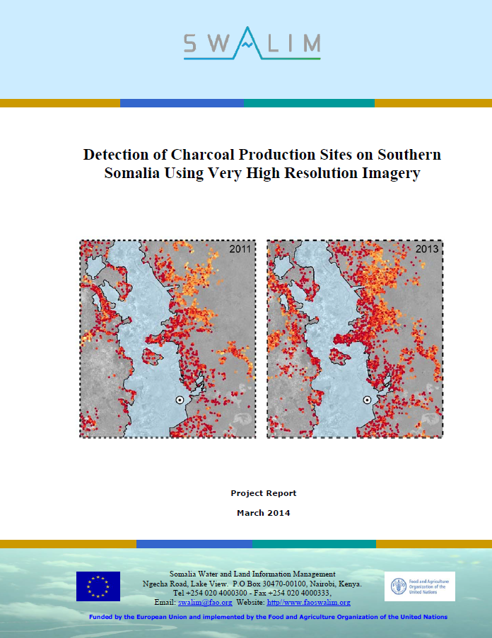
Ogaanshiyo goobo dhuxul laga soosaaro gudaha koonfurta Soomaaliya iyadoo la isticmaalayo masawirro si heer sare u bayaansan
Ka dib markii wax ka badan 20 sano ay xasilloonni darro rayid jirtey, macluumaad deegaaneedka ee Koonfur Soomaaliya waa yar yahay halka markhati cad oo ah in dhaqaalaha dagaalka uu sii shiday colaadda oo degdeg u ciribtiraya khayraadka dabiiciga ah ee dalka, gaar ahaan geeda la shito. Geedaha dhuxusha laga soo saaro waa mid ka mid ah ganacsiyada ugu xoogan ee taageeraya dagaal oogeyaasha sida kooxda Islaamiga xagjirka Al Shabaab, taasoo xukumaysay Koonfurta Soomaaliya laga soo bilaabo 2006 ilaa 2012 oo welina ku dambaysa qaybo ballaaran. Daraasaddan, markii ugu horeysay ayaa loo isticmaalay masawirro dayax-gacmeed oo si heer sare u bayaansan horaantii sanadkii 2011 iyo horraantii 2013 si loo soosaaro hannaan khariidayn kalabar-automaatik ah ee goobo dhuxul soosaar si tusaale muuqda u ah geedo baabi’in gaartey aag deegaan oo 6000 km2 ka badan oo ku yaal hareeraha Webiga Juba gudaha koonfur Soomaaliya. Saxnimada isticmaalaha hab kalabar-automaatik ah ee baaris goob dhuxul soosaar waxay kala duwanaadey qadar u dhaxaysa 81,7% sanadkii 2011 iyo 87,3% sanadkii 2013, halka saxnimada soo saarahu ahayd 68,2% iyo 65.5% midkiiba, marka la barbadhigay tarjumo muuqaal, oo waqtigii loo baahnaa si weyn u yaraysay. Falanqaynta isbeddellada u dhexeeya labada taariikh waxay noqotay in qiyaasta khasaare geedo uu celcelis ahaan yahay 3.3%, oo u dhigmaysa 520.520 oo geed muddo 2 sano ah. Natiijooyinku waxay caawinayaan in si fiican loo fahmo xaddiga iyo saamaynta dhuxul soo saarku gaarsiisanyahay gudaha Koonfur Soomaaliya waana tallaabadii ugu horeysay oo loo qaado dhinaca horumarinta habka kormeerka iyo la socoda dhuxul soo saarista.
Publication Type:
Technical report
Publication Date:
Author:
Corporate Author:
RSM-03 Detection of charcoal production sites in southern somalia using very high resolution imagery
Following more than 20 years of civil unrest, environmental information for Southern Somalia is scarce while there is clear evidence that the war economy fuelled by the conflict is rapidly depleting the country’s natural resources, especially the woody biomass. Wood charcoal production is one of the most relevant businesses supporting war regimes such as the extreme Islamist group Al Shabaab, which has ruled in Southern Somalia from 2006 to 2012 and is still occupying large areas.
In this study, we first used Very High Resolution (VHR) satellite imagery of early 2011 and early 2013 for developing a semi-automatic mapping method of charcoal production sites as a proxy of tree loss over a 6000 km2 area along the Juba River in Southern Somalia. The user’s accuracy of semi-automatic charcoal production site detection varied between 81.7% for 2011 and 87.3% for 2013, while the producer’s accuracy was 68.2% and 65.5% respectively and, as compared to visual interpretation, reduced significantly the required time. The analysis of the changes between the two dates led to an average tree loss estimation of 3.3%, corresponding to 520,520 trees over the 2 years period. The results help to better understand the dimension and impact of charcoal production in Southern Somalia and are a first step towards the development of a charcoal production monitoring system.
Publication Type:
Technical report
Publication Date:
Author:
Corporate Author:
SWALIM Update Issue 4
We are pleased to share Issue 4 of our quarterly newsletter “SWALIM Update” for the period November 2013 – January 2014. The newsletter provides updates on SWALIM water and land information management activities such as: SWALIM Early Warning Information Saves Lives; Building Resilient Communities through Disaster Risk Reduction and Early Warning; SWALIM Completes Survey of Strategic Emergency Boreholes in Northern Somalia; Fostering Accountability through Cash Based Intervention Remote Monitoring; SWALIM supports Somaliland Ministry of Agriculture to survey agricultural areas among others. We hope you will enjoy this edition. You feedback will be highly appreciated.
Publication Type:
Newsletter
Publication Date:
Author:
Corporate Author:

Mapping Forest Degradation Caused by the Recent Increase of Charcoal Production in Southern Somalia
Following more than 20 years of civil unrest, environmental information for Southern Somalia is scarce while there is clear evidence that the war economy fueled by the conflict is rapidly depleting the country’s natural resources and especially the woody biomass. Wood charcoal production is one of the most relevant businesses supporting war regimes such as the extreme Islamist group Al Shabaab, which has ruled in Southern Somalia from 2006 to 2012 and is still occupying large areas.
In this study we first used Very High Resolution (VHR) satellite imagery of February 2013 for developing a semi-automatic mapping method of charcoal production sites as a proxy of tree loss over a 754 km2 woody area along the Juba river in Southern Somalia. The accuracy of semiautomatic charcoal production site detection varied between 80 and 95% as compared to visual interpretation and reduced significantly the subjectivity and the required time. The analysis was then applied to previous years (2011-2012) for a 52.6 km2 subset of the study area, and led to a tree loss estimation of 8.63%, corresponding to 15,434 trees over the 3 years period. The results are crucial for better understanding the dimension and impact of charcoal production in Southern Somalia and are a first step towards the development of a charcoal production monitoring system.
Publication Type:
Journal Article
Publication Date:
Author:
Corporate Author:
SWALIM
Range policy
Somalia is situated in northeastern Africa and covers an area of 637 660 km2. It has the longest coastline in Africa, being bordered by the Gulf of Aden to the north and the Indian Ocean to the east. The country is bordered by Kenya in the south, Ethiopia in the west and by Djibouti in the north-west. The country can be divided in five distinct physio-geographic zones differentiated by topography:
Publication Type:
Other
Publication Date:
Author:
Corporate Author:
Pages
 RSS feed [compliant with the Agris AP] |
  Agris AP XML